Live Geo-referenced Storm Chaser Video. First in the Field Aerial Live Streaming and Aerial Storm Intercepts. High Resolution Level II Radar Data. Severe Weather Forecasts and Reports by Storm Chasers/Severe Weather Videographers Verne, Michael and Eric Carlson. For live stream and video licensing contact us at: vernecarlson@hotmail.com

KRDO ColoSprgs Storm Chasers!

KRDO

KAKE Wichita Storm Chase Team!

KAKE

Denver's Channel 7 Storm Chasers

KMGH 7 News

License this Live Stream Now!

Follow us LIVE on iMap Tracker! When you see a car we are live.


Sunday, April 30, 2006

Potential Chase Day Tuesday May 2

Well SPC has a huge slight risk area out on the day 3 outlook for most of the central plains. I tried to narrow this down by looking at the models. Both the NAM and GFS show a jet max over the northern plains at that time but they differ on the placement of the surface low and moisture return. NAM has the low up into NE with lower Tds while the GFS has the surface low in w KS with Tds as high as 70 in e KS. The GFS has over done the Tds all season so I prefer the NAM solution with 60s Tds and the surface low in NE. Depending on how this setup looks in the next couple days I may just take a day off to chase it if it's not too far east as I'd most likely be going this one solo.

Friday, April 28, 2006

Chase Log Update

Update on the chases so far this year:

March 4 - March forth into eastern CO solo cirrus shield bust - 500 miles
March 7, 8 - Two day tour of eastern KS cirrus shield bust with Michael and Tony L - 1500 miles
March 30 - Haul balls eastern NE, KS linear high speed chase with Michael and Tony L - 1500 miles
April 1 - April fools 4 state loop CO, KS, OK, TX, OK, KS, CO chase with Tony L and Jon V -1500 miles
April 15 - Tax day taxing chase NE into IA with the CO and CSU chasers - 1350 miles
April 23 - Lightning chase in sc KS eight of us packed in two cars - 1000 miles

7 chases
7350 miles so far!

Monday, April 24, 2006

April 23, 2006 Central Kansas


Dodge City, KS


Coldwater, KS


Dodge City, KS

Coldwater, KS

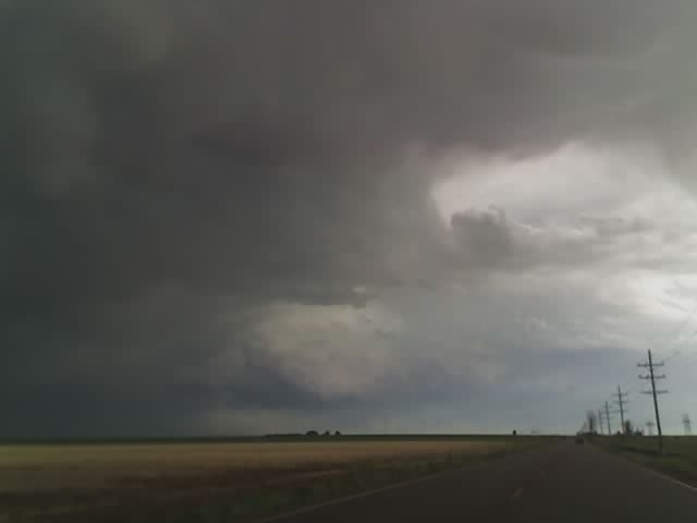
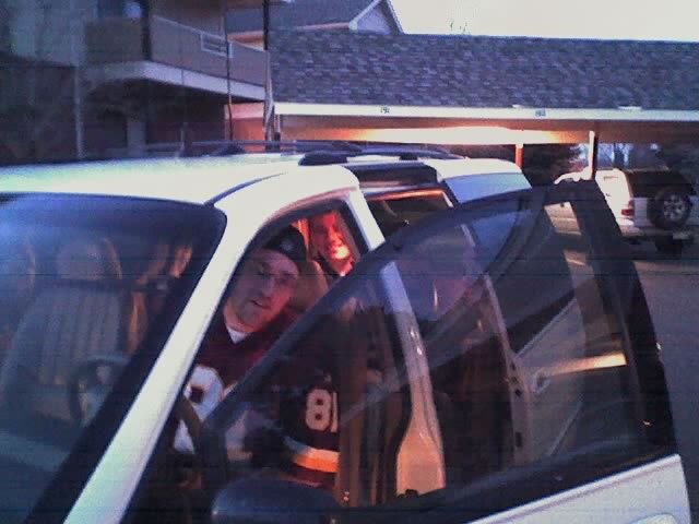
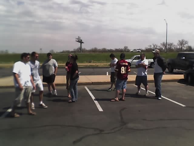
Myself, Michael, Tony L and friend Jennifer Brindley, Tom Dulong, Allan Covelli, Jon Van De Grift and his girlfriend Allison started out in Wakeeney, KS and decided that the action south of us was too tempting to pass up so we headed south out of Hays to spend the rest of the afternoon getting down to the tail-end-charlie storms. Storm speeds this day were 30kts, not the 60kts of chases previous so we were actually able to catch up to them.

We spent a few of the evening hours moving east of the tail-end storm on hw160 as it would move towards us, start raining and then we would move further east. We spent most of this time between Coldwater and Medecine Lodge, KS.

On the way back we caught some great lightning near Dodge City, had dinner at the Sonic drive in and got back to Denver where my head hit the pillow at 4:30am

Not a bad little chase - still waiting for that first tornado catch of the year. Chase cation is less than 3 weeks away now!

1000 miles

Sunday, April 23, 2006

Our current location is Dodge City, KS

Latest image from Verne's mobile picture phone. Looking south from Greensburg, KS at the tail end charlie storm.

Latest image from Verne's mobile picture phone. Strong outflow dust gets kicked up to our west near Kinsley, KS

Latest image from Verne's mobile picture phone. Having lunch in Colby, KS

Heading out to our next destination. Colby, KS

Saturday, April 22, 2006

Sunday seems like it has potential


EDIT: Latest NAM is out, target now looks like starting at Oakley chasing to Hays. 500mb winds are a bit stronger. Cap looks breakable.

With Monday's potential way too far southeast into eastern OK (and far too weak of a setup) I am liking the idea of a Sunday out and back chase somewhere in the CO/NE/KS tri-state intersection. Yesterday's GLD AFD had mentioned Yuma, CO to Hill City, KS in a narrow band just north of there.

SPC has a higher prob out east into e KS but that is for the MCS expected to develop. Discrete cells with tornado potential may be closer to e CO/ KS

Day 2 outlook:

"WEAK MID-LEVEL IMPULSES EMANATING FROM WRN STATES TROUGH ARE EXPECTED TO MOVE EWD ACROSS THE PLAINS TOWARD THE MID MS VALLEY. LARGE SCALE ASCENT WITH THESE FEATURES AND HEIGHT FALLS ACROSS THE NRN/CENTRAL PLAINS IN ADVANCE OF CANADIAN TROUGH ARE EXPECTED TO SUPPORT THUNDERSTORM DEVELOPMENT BY MID-LATE AFTERNOON ALONG THE SURFACE BOUNDARY FROM SERN WY INTO CENTRAL KS. INCREASING WLY MID-LEVEL WINDS ATOP STRENGTHENING CENTRAL/SRN PLAINS SLY LLJ BY LATE SUNDAY AFTERNOON WILL RESULT IN STRONG DEEP LAYER SHEAR SUPPORTING SUPERCELLS CAPABLE OF PRODUCING TORNADOES"

Den AFD:

"SOME LOW LEVEL THETA E MSTR IS PROGGED TO BE OVER NORTHEASTERN COLORADO DURING THEAFTN. BEST MSTR APPEARS TO BE ALONG AND EAST OF A LINE EXTENDING FM NEW RAYMER TO AKRON. INTERACTIVE SOUNDINGS STILL SHOW GOOD DIRECTIONAL SHEAR WITH CAPES OVER 2000 J/KG. STILL A FAIR AMOUNT OFCIN AS WELL...BUT IT CERTAINLY BEARS WATCHING."

North Platte AFD:

"NAM/GFS IN GOOD AGREEMENT WITH POSITION OF SFC LOW TRACK ACROSS KS ON SUN. THIS KEEPS THE WARM FRONT TO THE SOUTH OF THE CWA ALONG WITH CHANCES FOR SEVERE WEATHER. THIS POSTION THOUGH WILL BE WATCHED AS A NORTHERLY TREND WOULD BRING THE SEVERE THREAT INTO THE SOUTHERN HALF OF THE CWA."

Thursday, April 20, 2006

Potential Eastern Colorado Chase Sunday


I'm liking the setup for Sunday in eastern Colorado more and more. The latest ETA run shows nice theta-E air wrapping in around a surface low over the palmer divide. Shear profiles look good, Tds in the mid 50s and the location of the upper low and energy reminds me alot of another eastern CO day. May 10th 2004!! Only downside is the potentially strong cap with 700mb temps at 10-12C.

Denver AFD: "FCST SOUNDINGS SHOW DECENT INSTABILITY WITH CAPES OVER 2000J/KG OVER THE FAR NERN PLAINS. SPRING TIME IN THE ROCKIES...SNOW TO SEVERE WEATHER A POSSIBILITY."

Run for cover in Minnesota!


People in western Minnesota had better take cover if those are really tornado warnings!

Wednesday, April 19, 2006

Chases so far this season

Update on the chases so far this year for me:

March 4 - March forth into eastern CO solo cirrus shield bust - 500 miles
March 7, 8 - Two day tour of eastern KS cirrus shield bust with Michael and Tony L - 1500 miles
March 30 - Haul balls eastern NE, KS linear high speed chase with Michael and Tony L - 1500 miles
April 1 - April fools 4 state loop CO, KS, OK, TX, OK, KS, CO chase with Tony L and Jon V -1500 miles
April 15 - Tax day taxing chase NE into IA with the CO and CSU chasers - 1350 miles

6 chases
6350 miles so far!

Chase potential Monday April 24th


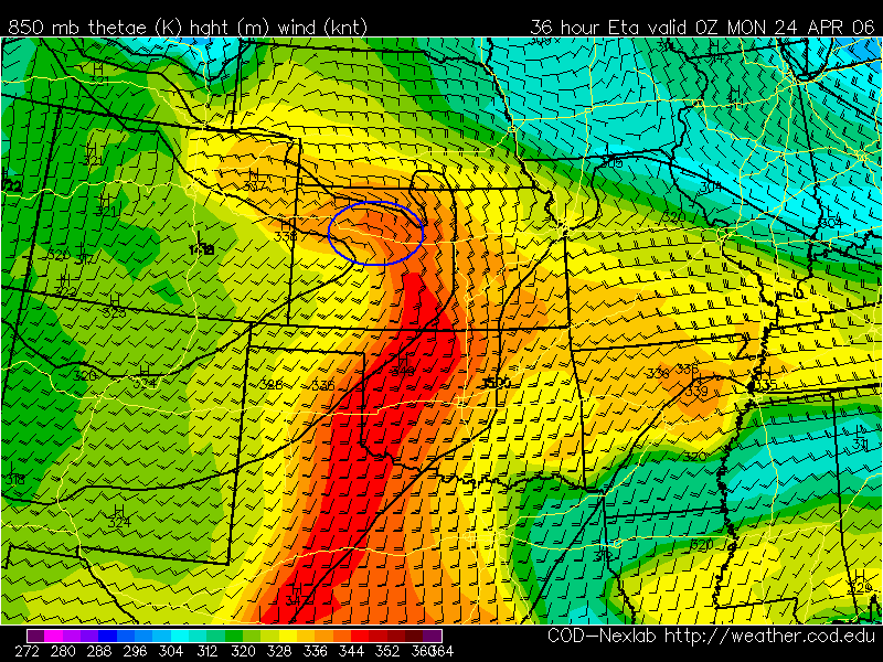
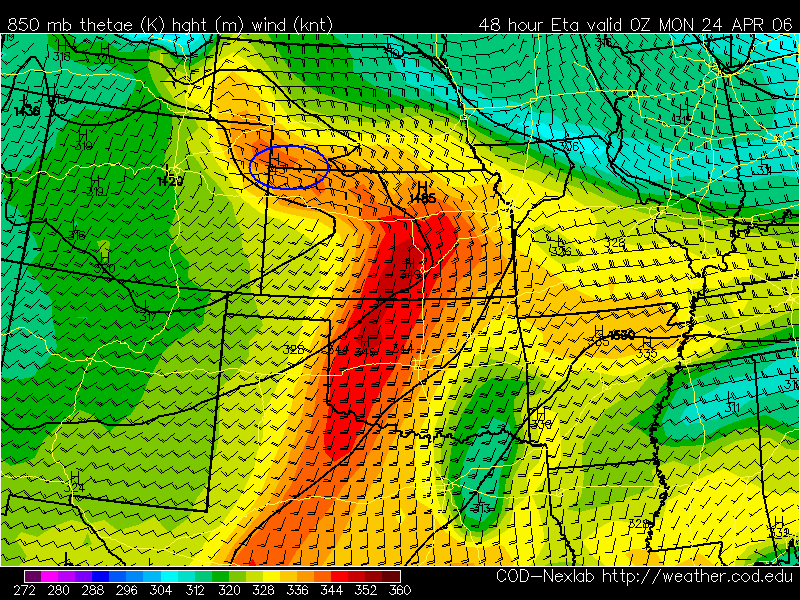
It's still five days out but the GFS is showing a potential setup for severe weather on Monday April 24th. Looks like the area this time would be down in the panhandles of OK and TX into west and central OK.

Yesterday Chris Rozoff was discussing how the development and breakdown of the Omega blocking pattern is similar in setup to events leading up to May 3rd 1999. Gotta keep an eye on this one as this could be the system that breaks through into that high Theta-E air.

Tuesday, April 18, 2006

The Exped is a star on the Weather Channel


My car was shown on TWC's "It Could Happen Tomorrow, Boulder Flash Flood" off of Tony L's video on sunday night. These shots I believe are actually from Burlington, CO spring of 2005.

Sunday, April 16, 2006

Back at home after Saturday's chase

Henderson, IA looking northeast


Glenwood, IA looking southeast


Polk, NE looking south

Mileage: 1350
First Chase into Iowa!

Well yesterday was a bit frustrating but you make your forecast pick your target area and roll the dice and hope you come out within range of a tornadic supercell. With all the talk about a Cold Core setup I think I had this firmly in my mind when we left Grand Island, NE and headed northeast to Central City on HW30. It looked as if the 'string of pearls' storm chain would setup but wiser heads prevailed and we continued to keep our eyes on development to the south. Storms of the day would be down by Beatrice and in Oteo County in the tail end of each line that formed. This has been the story of most chases this year. We did our best to get east and south and did we ever! We ended up three counties into southwest Iowa - first time for many of us chasing in Iowa. Still I can say it was a fun chase getting to be out again with most of the Colorado Gang as well as new friends from CSU!

Saturday, April 15, 2006

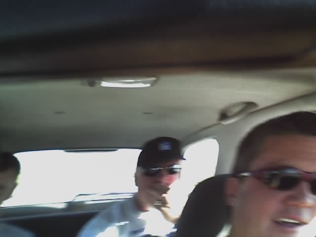
Latest image from Verne's mobile picture phone. Twelve people and five cars, we all get together in the same spot which is always a good sign that we've picked a good target starting point! Starting from the left we have Chris Rozoff and his friend, Becca Mazur and her group - all from CSU, Tony L, Michael C, Tom Dulong and his friend James from Australia. Katie Burtis and Alan Covelli are blasting east along I-80 to get here in time for storm initiation.

Latest image from Verne's mobile picture phone. Hanging out in Grand Island, NE waiting for the storms to form. We are sitting just southeast of the triple point.

Chase Morning at Grand Island, NE

Well got up this morning and the first thing I pulled up were the surface obs and was not happy to see that the dewpoints have not yet advected up into NE. But the winds here are screaming out of the southeast at 20kts and all the wind barbs are lined up to bring the 54td air up from Topeka and points south of I-70 into KS. The surface low is nice, consolidated now and deepening in se WY at 996mb so everything is in place except the moisture. If that moisture can advect in here by 18z I think we will be good to go for today's action.

Katie is almost to Rawlins, WY which puts her into Cheyenne at 8am - a full hour ahead of her best hope to meet up with Alan so the two of them may actually be the next group to get out here!

Tony is meeting Tom and heading out of Denver at this hour so they're good to get here in time for initiation as well.

The day 1 outlook should be out soon so we'll see if SPC is put off at all by the lack of moisture return at this hour.

Friday, April 14, 2006

Latest image from Verne's mobile picture phone. We are at the holiday Inn just off I-80 at Grand Island, NE. Chris and his chase partner decided to stay overnight at North Platte, NE. NOAA weather radio was talking tornadoes east of hw 83 for tomorrow. hw 83 is the highway north-south through North Platte (I believe). We are in a good spot for tomorrow, we should be able to meet up with everyone and adjust to our target tomorrow! Katie, Alan, Tony and Jon - see you guys in the morning! Bring on the storms!

Katie, your forcast looks right on - I hope things slow down and move west, that'll benefit us all and keep us from getting into IA. Pretty much anywhere from central NE east is going to be the target area!

Latest image from Verne's mobile picture phone.

Heading out to our next destination. Kearny, NE

Thursday, April 13, 2006

Des Moines, IA AFD mentioning Tornadoes southwest of area for Saturday

LOOKING AHEAD TO NEXT AND MORE SIGNIFICANT SYS...GFS SEEMS FASTER THAN ALL OTHER MODELS AND SLOWER SOLUTIONS FAVORED. WARM ADVECTION INCREASES...BUT MAINLY TO OUR SW OVERNIGHT...SO HAVE ADJUSTED THE SLIGHT CHANCE WORDING THE SW. ISENT LIFT SPREADS INTO IA DURING THE MORNING WITH POPS INCREASING AND THEN BECOMING MORE WIDE SPREAD DURING THE AFTERNOON. FOLLOWING NAM SOLUTION...WHICH IS SIMILAR TO OTHER MODELS...SUGGESTS CURRENT ERN PACIFIC UPPER LOW REACHING MO VALLEY AS A PROGRESSIVE WV WITH ATTENDANT SFC LOW ONLY SLIGHTLY AHEAD. INSTABILITY AXIS WRAPS INTO LOW FROM NWRN MO ADVANCING INTO SWRN IA DURING THE EVE. WILL NOT BREAK DOWN DETAILS...BUT PATTERN RECOGNITION...SHEAR AND INSTABILITY ALL POINT TOWARD DECENT SVR WX EVENT WITH ALL MODES AND SOME TORNADOES POSSIBLE. STRONG QG FORCING ON NOSE OF DRY SLOT SHOULD OVERWHELMANY CIN. SHOULD EXPAND INTO LARGE MCS SAT NIGHT WITH NOSE OF WARM ADVECTION SURGING INTO IA SO EXPANDING LIKELY WORDING SAT NIGHT. PCPN MAY LINGER INTO SUN ERN HALF WITH LITTLE CHANGE THAT PERIOD.

Wednesday, April 12, 2006

Model analysis for Saturday April 15th

Saturday April 15th 18z

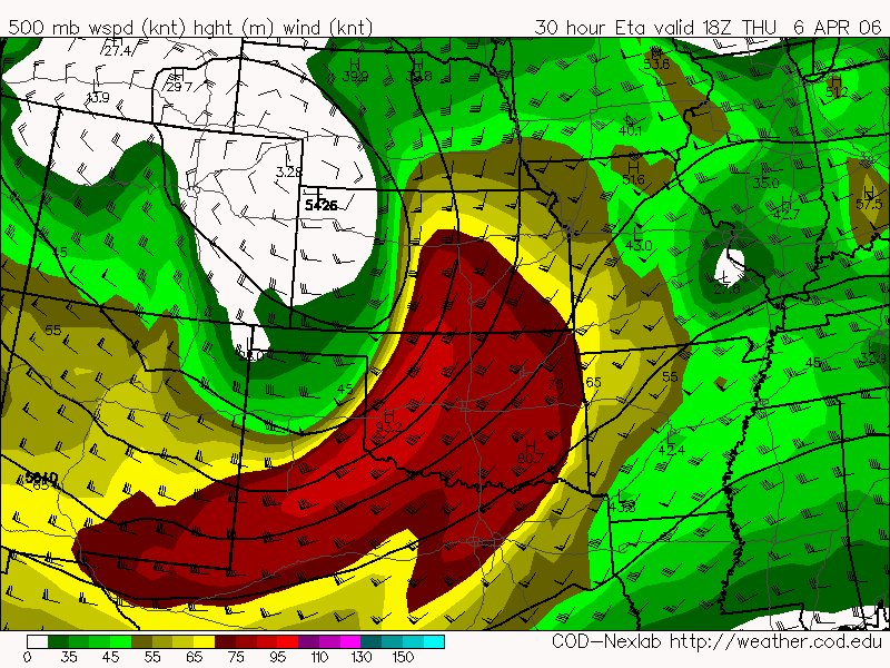
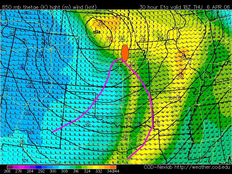
Thursday April 6th 18z

Doing a little model analysis to try and determine a target area for Saturday. Above I have compared the tornadic setup of April 6th (lower image) to the same 18z model output for upcoming April 15th. Looking at April 6th I see that the area of tornadic supercells was southeast of the surface low at the nose of the 500mb jetstreak. Applying the same analysis to the upcoming setup gives us a target area of eastern NE. The days are remarkably similar for the parameters that I've looked at with some notable differences. The most notable is the area of the 500mb jet streak and the less focused Theta-E air near the dryline. Time will tell if this sort of geometric analysis will play out.

Sunday, April 09, 2006

Next potential chase day April 15


Looking ahead at the GFS it looks like the strong upper low that persists off the CA coast comes into the plains on Sat April 15th. Moisture return looks adequate with 60Tds up into NE. It's a long ways out so we'll see how the models evolve this system.

Chris Rozoff and the CSU gang caught some great tornadoes on Thursday April 6th in north-central KS! Here's his report: http://lamar.colostate.edu/~cmrozoff/weather/index.html

Friday, April 07, 2006

Major Tornado Outbreak in the Midwest

Nashville, TN is reporting damage in town, and this may be the highest tornado probablity ever! 60% hatched!

Thursday, April 06, 2006

Big Tornadoes in Kansas today!

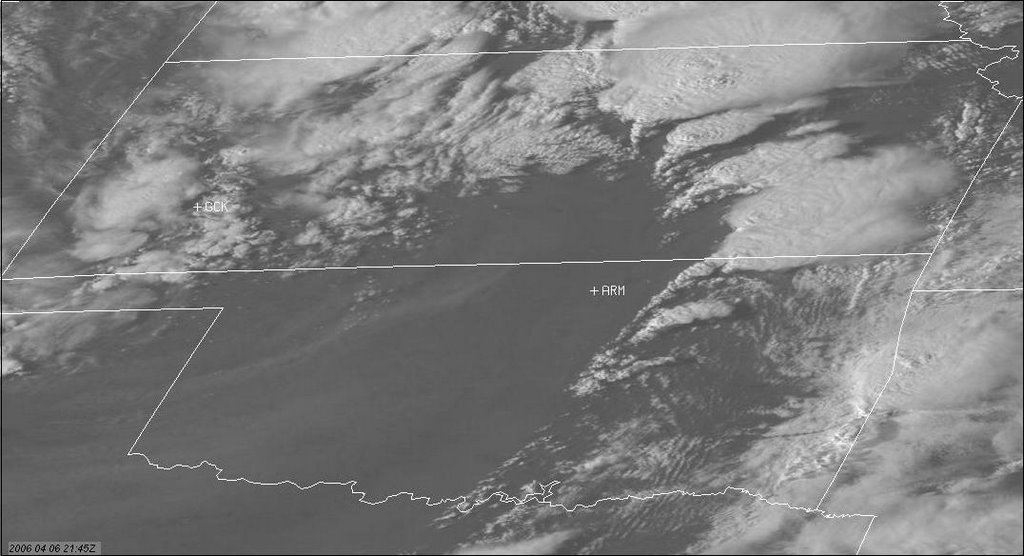
Two hours later at 21:45z storm that will create the Hanover, KS tornado is the dominant cell to the north with overshooting tops clearly visible.

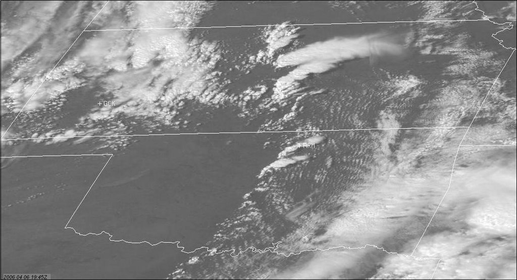
By 19:45z the dryline is clearly evident and the cell that will be the big producer is gaining strength near Salina, KS

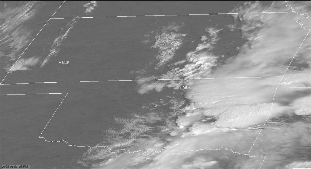
It's fun to go back and look at the progression of a big tornado day using the visible satellite images. Here at 15:55z we see the morning setup.

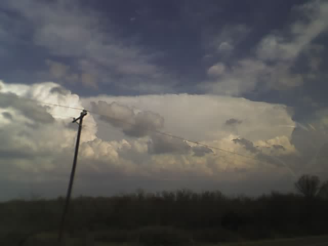
Doug Keisling of BNVN caught this nice elephant trunk tornado today near Hanover, KS. So far today there have been over twenty reports of tornadoes in central and northeastern KS.

Also today Tony L's 7news Storm Chaser Blog with Roger Hill and Tim Samaras went live at:
http://www.thedenverchannel.com/stormchasersblog/index.html

Tony always does the best job of describing the mood and the feel of each and every moment of the chase so it'll be great for a bigger audience to read his awesome posts!

Wednesday, April 05, 2006

Another potent chase setup Thurs April 6


If I had a chase partner for tomorrow I would definately be going to central NE with the plans of following storms into IA. Driving the 8hours or so that it would take to get back in the wee hours of Friday morning would just be too hard to do alone. So... I will be passing on this system and favoring the 3-4 more we get in the next few weeks.

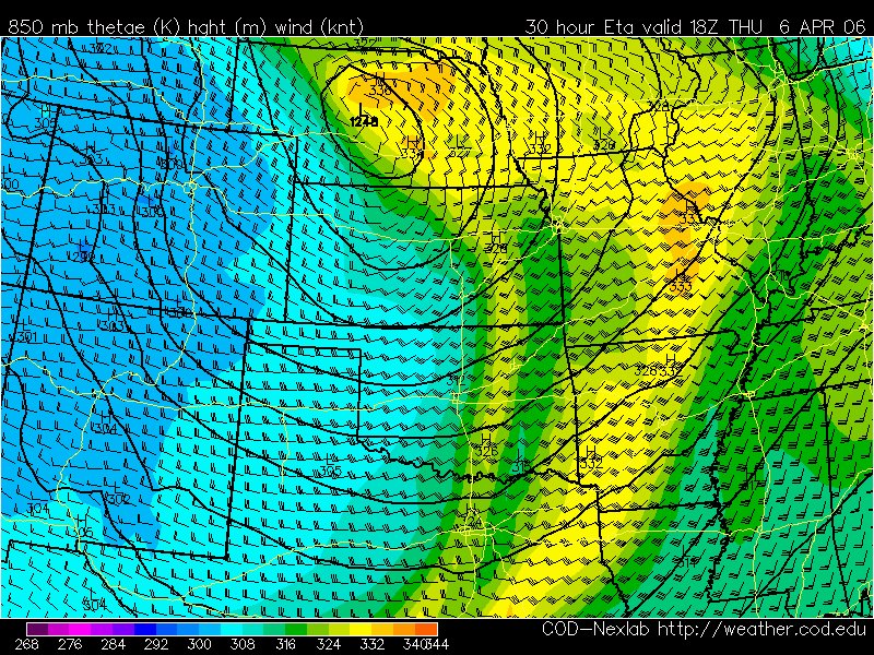
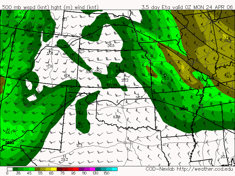
The thing that I really don't like about this setup is the near vertical stacking of the surface and upper lows that really limit directional shear. All other parameters look good, if I where chasing I would target Norfolk, NE which would put me east of the triple point.

Tuesday, April 04, 2006

Days Chased so far

Just a quick update on the chases so far this year for me:

March 4 - eastern CO cirrus shield bust - 500 miles
March 7, 8 - eastern KS cirrus shield bust - 1500 miles
March 30 - eastern NE, KS linear high speed chase - 1500 miles
April 1 - CO, KS, TX, OK, KS, CO chase with Tony -1500 miles

5000 miles so far!

Monday, April 03, 2006

Grass fire at 128th and Indiana

Latest image from Verne's mobile picture phone. Although you can't see it very well in this picture 100's of acres were burned at the bottom of the hill from our home on Sunday. Smoke could be seen for miles and enshrouded Denver most of the afternoon.

Sunday, April 02, 2006

Saturday April 1st Southwestern OK Chase

Latest image from Verne's mobile picture phone. From 4:00am this morning gassing up in Goodland, KS. One pump had this sign on it and was not funcitoning. The other three where fine. Wouldn't want to be standing by a gas pump whent it was hit by lightning!

Mileage for this chase: 1500 miles

Saturday, April 01, 2006

Latest image from Verne's mobile picture phone. Looking back to the southwest at the developing squall-line from I-40 east of Elk City, OK

Our current location is Elk City, OK. We pull ahead of the storm and approach it from the east side.

Latest image from Verne's mobile picture phone. Racing like madmen towards the cells south of I-40 near extreme southwestern OK.

Latest image from Verne's mobile picture phone. In Pampa, TX we run into Amos M. and Eric N. and thier friend. Katie B. informs me that an MD has been issued to our southeast. Storms in better moisture begin to fire down south of I-40 in Texas.

"We're Gone!"

Heading out to our next destination. Pampa, TX

Latest image from Verne's mobile picture phone. In OK, crossing into the panhandle from Liberal, KS heading into the target area.

Heading out to our next destination. Gassing up in Limon, CO

The Carlsons', Verne, Michael and Eric

The Carlsons', Verne, Michael and Eric

Contact Me for Helicopter Shots!

Flying Monkeys

My Blog List

Blog Archive