
KRDO ColoSprgs Storm Chasers!
KAKE Wichita Storm Chase Team!

Denver's Channel 7 Storm Chasers


Tuesday, February 27, 2007
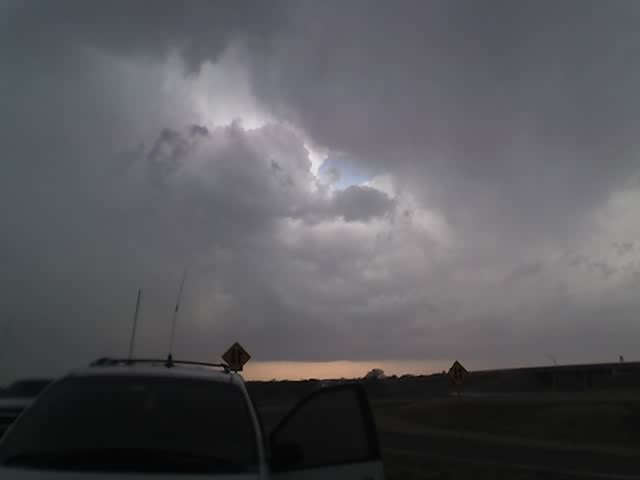
Testing my new 8525 PocketPC
Monday, February 26, 2007
From Mike Nelson's 7 Weather Blog
February 24, 2007 - Local Storm Chasers Bag First Tornado Of Season
Local storm chasers Verne Carlson, Michael Carlson and Tony Laubach saw their first tornado of the 2007 chase season on Friday.
In anticipation of strong developing low pressure on the central plains, they left Denver Thursday afternoon for Garden City, Kansas.
After analyzing data on Friday, they decided to target western Oklahoma and the Texas panhandle for severe thunderstorm development.
A dryline setup Friday afternoon between Amarillo and Shamrock in the Texas panhandle, so the storm chasers made their way west along Interstate 40 to the small town of McLean.
A dryline is the boundary between moist air and dry air, which serves as a focal point for thunderstorm development.
By the afternoon hours, three thunderstorm cells fired up and moved north along the dryline. The first storm was rather weak, but the second storm showed signs of rotation.
As the rotation grew stronger, a funnel cloud dropped from the base of the storm. The funnel soon took on the classic cone shape and dropped to the ground, forming a tornado.
The tornado stayed on the ground about 5 minutes near the town of McLean, Texas. You can see a picture of the twister by clicking here.
Now Tony, Verne and Michael are driving through 60 mph wind gusts from the departing storm as they make their way home to Colorado.
Saturday, February 24, 2007
Feb 23, 2007 McLean, TX Tornado Chase
 Here's our crew for the case ((c) Jketcham) Tony, Myself and Michael after our successful tornado intercept!
 Tornado at it's most pronounced. We are viewing it through the powerpoles over McLean, TX as the tornado moves north of town.
 Rotation moves over I-40 as a funnel aloft.
Intercepted the tornado that came south of I-40 and moved over McLean, TX then touched down briefly north of town before dissipating. Chasing with Michael and Tony Laubach. We started the morning in Garden City, KS - drove south and west through western OK while checking data all the way. Tony's tethered mobile phone proved to be priceless as we were able to see the SPC mesoanalysis pages and target eastern TX panhandle.
First Tornado in Feb and first in Texas! 2007 is off to a great start!
Michael and I made it onto the 5:00pm and 10:00pm News 7 abc broadcast.
Michael and I made it onto the 5:00pm and 10:00pm News 7 abc broadcast.
The SPC storm archive page for this date is available here:
Mileage: 1150
Motel Stays: 1
Friday, February 23, 2007


Thursday, February 22, 2007
Day 1 SPC is out this evening, 15% torn 60% hail unreal!


...THERE IS A MDT RISK OF SVR TSTMS FROM CENTRAL KS...SWD INTO NWRN TX... ...THERE IS A SLGT RISK OF SVR TSTMS SURROUNDING THE MDT RISK FROM CENTRAL TX INTO SRN NEB... ...SIGNIFICANT SEVERE WEATHER EPISODE IS POSSIBLE ACROSS MUCH OF THE CENTRAL AND SOUTHERN PLAINS LATE FRIDAY INTO SATURDAY MORNING... A POWERFUL UPPER TROUGH IS MOVING ACROSS CA EARLY THIS MORNING. THIS FEATURE WILL SHIFT EAST ACROSS THE CNTRL/SRN ROCKIES LATE TODAY...INDUCING LEE CYCLOGENESIS OVER ERN CO/NWRN KS BY EARLY EVENING. PARAMETERS APPEAR TO BE COMING TOGETHER FOR WIDESPREAD...POTENTIALLY SIGNIFICANT SEVERE THUNDERSTORMS ACROSS MUCH OF KS...OK...INTO NORTH CENTRAL TX AHEAD OF ADVANCING COLD FRONT. DAMAGING WINDS...VERY LARGE HAIL...AND TORNADOES ARE POSSIBLE. INTENSE MID LEVEL HEIGHT FALLS WILL SPREAD/DEVELOP INTO THE HIGH PLAINS DURING THE LATTER HALF OF THE PERIOD WHERE 12 HOUR FALLS IN EXCESS OF 200 M ARE POSSIBLE. ADDITIONALLY...STRENGTH OF UPPER SYSTEM IS EVIDENT BY DIGGING UPPER JET INTO WEST TX WHICH SHOULD APPROACH 110 KT BY THE END OF THE PERIOD AT 500 MB. NEEDLESS TO SAY...SHEAR PROFILES WILL BECOME VERY INTENSE ACROSS THE SOUTHERN AND CENTRAL PLAINS AS THIS UPPER SPEED MAX SPREADS ATOP STRENGTHENING LLJ FROM TX INTO ERN NEB. OF PARTICULAR CONCERN THIS PERIOD IS THE EXPECTED BOUNDARY LAYER MOISTURE RETURN ACROSS TX...NWD INTO THE STRONGLY FORCED REGION OVER OK INTO KS. LATE EVENING MODEL GUIDANCE INSISTS MID-UPPER 50S DEW POINTS WILL SURGE NWD ALONG AN AXIS FROM THE EDWARDS PLATEAU OF SWRN TX...NWD ACROSS WRN OK...POSSIBLY INTO PORTIONS OF SOUTH CENTRAL KS. GIVEN THE VERY COLD MID LEVEL TEMPERATURES THAT WILL SPREAD ACROSS THIS REGION...APPROACHING MINUS 20 AT 500MB...MORE THAN ADEQUATE INSTABILITY SHOULD EVOLVE ALONG/EAST OF DRY LINE BY 00Z. AT THIS TIME IT APPEARS VERY STEEP LOW-MID LEVEL LAPSE RATES WILL EVOLVE ACROSS THE HIGH PLAINS OF TX DUE TO STRONG DIURNAL HEATING. SURFACE TEMPERATURES SHOULD WARM INTO THE MID 70S ACROSS NWRN TX WITH DEW POINTS EXPECTED TO HOLD IN THE MID 50S ALONG THE DRY LINE. FORECAST SOUNDINGS SUGGEST MLCAPE VALUES COULD EASILY EXCEED 1500 J/KG FROM WEST OF ABI...NWD ALONG THE TX/OK BORDER. IT APPEARS PARCELS SHOULD FREELY CONVECT...DESPITE WEAK CONVERGENCE ALONG THE DRY LINE...MAINLY DUE TO HEATING AND WEAKENED CAP. LATEST THINKING IS ISOLATED SUPERCELLS WILL EVOLVE ACROSS NWRN TX INTO SWRN KS BY 00Z...THEN MOVE QUICKLY ENEWD AT ROUGHLY 40 KT WITHIN A VERY FAVORABLE SHEARED ENVIRONMENT. FORECAST SOUNDINGS SUGGEST SHEAR WITHIN THE INFLOW LAYER WELL IN EXCESS OF 400 M2/S2. IF SUPERCELLS EVOLVE AS EXPECTED...TORNADOES ARE POSSIBLE. WITH TIME THIS ACTIVITY WILL EVOLVE INTO A SQUALL LINE...POTENTIALLY INTENSE...AS VERY STRONG FORCING SPREADS ACROSS THIS ONGOING CONVECTION. ADDITIONALLY...VERY LARGE HAIL SHOULD ACCOMPANY SUPERCELLS WITHIN INSTABILITY AXIS. A WELL ORGANIZED LINEAR MCS...WITH EMBEDDED SUPERCELLS...SHOULD SPREAD ACROSS MOST OF CENTRAL KS/OK INTO NCNTRL TX BY THE END OF THE PERIOD.


Wednesday, February 21, 2007
Friday is now on the Day 3 radar - looking good!

...GREAT PLAINS... AN IMPRESSIVE UPPER-LEVEL TROUGH WILL MOVE EWD ACROSS THE WRN U.S. FRIDAY CLOSING OFF OVER THE SCNTRL ROCKIES FRIDAY NIGHT. AHEAD OF THE UPPER-LEVEL SYSTEM...A VERY STRONG 70 KT LOW-LEVEL JET WILL DEVELOP IN THE SRN PLAINS AND A MOIST AXIS WILL SET UP FROM NW TX EXTENDING NWD ACROSS WRN OK INTO WCNTRL KS FRIDAY AFTERNOON. SFC DEWPOINTS BY LATE FRIDAY AFTERNOON SHOULD REACH THE 55 TO 58 F RANGE ALLOWING FOR POCKETS OF MODERATE INSTABILITY JUST EAST OF A WELL-DEFINED DRYLINE. ALTHOUGH PARTS OF THE MOIST AXIS MAY REMAIN CAPPED FRIDAY AFTERNOON...SOME THUNDERSTORM ACTIVITY SHOULD INITIATE BY LATE AFTERNOON OR EARLY EVENING ON FRIDAY ACROSS WRN OK AND THE LOW-ROLLING PLAINS OF NORTHWEST TX. ONCE CONVECTION INITIATES...SUPERCELL DEVELOPMENT SHOULD QUICKLY OCCUR DUE TO STRONG VERTICAL SHEAR OF 60-70 KT. IN ADDITION...STORM DEVELOPMENT WILL BE AIDED BY VERY STRONG DYNAMICS ASSOCIATED WITH THE EXIT REGION OF AN EJECTING 100 KT MID-LEVEL JET. FORECAST SOUNDINGS ACROSS NW TX AND WRN OK LATE FRIDAY AFTERNOON SHOW CLASSIC LOADED-GUN TYPE SOUNDINGS WITH 0-3 KM SRH INCREASING TO ABOVE 500 M2/S2 DURING THE EVENING. THIS SUGGESTS SUPERCELLS WILL BE CAPABLE OF PRODUCING TORNADOES. THIS COMBINED WITH 0-1 KM SHEAR VALUES EXCEEDING 30 KT WILL MAKE STRONG TORNADOES A POSSIBILITY FRIDAY EVENING...SHOULD STRONG CAPPING BE OVERCOME. VERY LARGE HAIL AND WIND DAMAGE WILL ALSO BE POSSIBLE WITH SUPERCELLS THAT DEVELOP. A BROKEN LINE OF SUPERCELLS AND/OR BOW ECHOES SHOULD MOVE EWD ACROSS WCNTRL KS...CNTRL OK AND NRN TX DURING THE OVERNIGHT PERIOD. SQUALL-LINE DEVELOPMENT APPEARS LIKELY AND SEVERE STORMS COULD OCCUR AS FAR EAST AS ERN OK/ECNTRL KS/NERN TX LATE IN THE PERIOD. ALSO...A FEW SEVERE STORMS COULD OCCUR IN CNTRL NEB BUT THIS WILL DEPEND ON THE AMOUNT OF MOISTURE RETURN THAT TAKES PLACE IN THE CNTRL PLAINS FRIDAY. IF MOISTURE RETURN ENDS UP BEING STRONGER THAN FORECAST...AN UPGRADE MAY BECOME NECESSARY IN LATER OUTLOOKS.
Tuesday, February 20, 2007
Sat Feb 24 the first chase day of the 2007 season?

 Saturday looks to be the best day of the coming system. Nice compact surface low in c KS and almost vertically stacked with the upper low. Would like to see the upper low slow a bit and stay back from the surface low.
 Wichita AFD is calling for low-topped supercells in central and south-central KS. Current target for Saturday: Hutchinson, KS
Friday Feb 23 the 'Day before the Day'

 Friday Feb 23 looks to be an outside chance of being the first severe weather day in the plains for 2007. The surface low is in a good position and is nice and deep. The upper level jet is a little far away at 0z at the current time. For Friday to be a good chase and not a nighttime event the system will have to speed up a bit. Current target for Friday: Pratt, KS
Wednesday, February 14, 2007
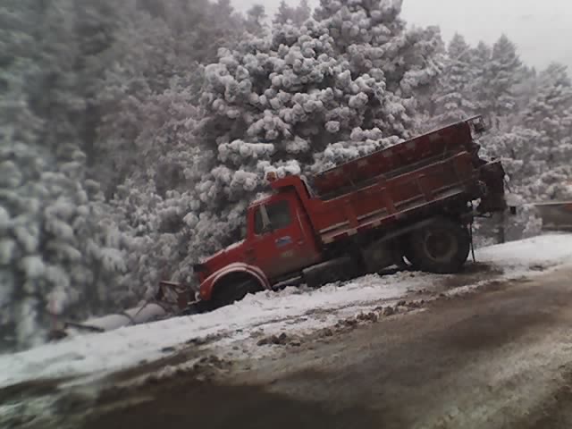
So icy on hw72 the plow even slid off the road!
Monday, February 12, 2007
Multimedia message

Friday, February 09, 2007
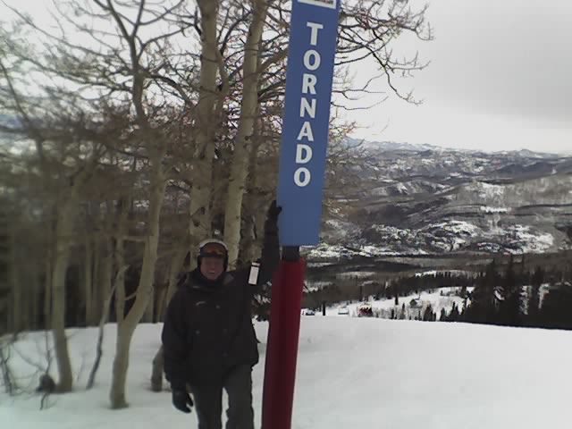
Some storm related runs at Steamboat, CO!
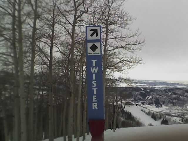
Latest image from Verne's mobile picture phone. This is the Storm Peak area at the Steamboat Ski Resort. Included are the Twister, Tornado, Cyclone, Vortex, and Hurricane. I have to say that the Tornado run was the best!

Subscribe to:
Posts (Atom)
The Carlsons', Verne, Michael and Eric

Contact Me for Helicopter Shots!
