Live Geo-referenced Storm Chaser Video. First in the Field Aerial Live Streaming and Aerial Storm Intercepts. High Resolution Level II Radar Data. Severe Weather Forecasts and Reports by Storm Chasers/Severe Weather Videographers Verne, Michael and Eric Carlson. For live stream and video licensing contact us at: vernecarlson@hotmail.com
License this Live Stream Now!
Follow us LIVE on iMap Tracker! When you see a car we are live.

Friday, October 31, 2008
Goodbye Subie
Subie has officially been donated to Goodwill and served me well over 100,000 miles and many chases. Rest well Subie...
Monday, October 13, 2008
DVD: Carlson Chasers Season 2008!

Our 2008 DVD is now available for purchase! Includes 2 hours of non-stop severe weather footage!


Includes full chapters of:
March 2
March 30
April 23
May 22
May 23
May 25
May 29
As well as an additional half-hour of nothing but assorted weather footage from this year!
Purchasing information can be found by clicking the "Buy Now" link here!
Saturday, October 11, 2008
No chasing this weekend - or is there?
Well as expected hurricane Norbert has cast it's influence into the e NM/w TX area and has all but cutoff all chances for the great kinematics to produce tornadoes. There will be a lot of rain and some marginally severe hail but not enough to warrant a trip down to the south. At the house here we are alternating between bright clear skies and low fog rolling in. This could be our first shot at some measurable snow for the 08-09 winter season!
Edit: SPC just put up a 5% tornado risk area for the w OK panhandle. I am seriously considering heading out the door and shooting down there. The vertical sheer today and tomorrow is amazing on the edge of the 110 kt 500mb jet!
Edit 2: Dann you said it - we need sunlight! Now it's 7:15pm MDT and we have a tornado watch for ne NM, must be driven entirely by wind dynamics. Wow STRONG TORNADOES possible:
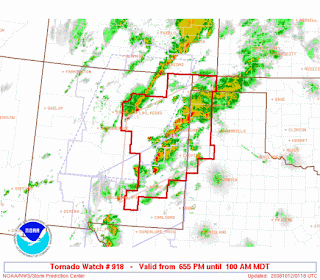
DISCUSSION...SCTD TSTMS/SUPERCELLS EXPECTED TO PERSIST ALONG SSW-NNE
CONFLUENCE ZONE IN E CNTRL/SE NM. OTHER STORMS EXPECTED TO PERSIST
ALONG SIMILAR CONFLUENCE BAND IN MORE DEEPLY-MIXED ENVIRONMENT IN N
CNTRL/ NE NM. STRENGTH OF EXISTING WIND FIELD...LIKELIHOOD FOR SOME
BACKING/STRENGTHENING OF NEAR-SFC FLOW...AND MOIST BOUNDARY LAYER
OVER ERN NM SUGGEST POTENTIAL FOR ISOLD BUT POSSIBLY STRONG
TORNADOES OVER THAT PART OF THE STATE AND IN ADJACENT PARTS OF TX.
HAIL/LOCALLY DMGG WIND WILL REMAIN POSSIBLE WITH STORMS IN THE N
CNTRL/NE NM.
Edit: SPC just put up a 5% tornado risk area for the w OK panhandle. I am seriously considering heading out the door and shooting down there. The vertical sheer today and tomorrow is amazing on the edge of the 110 kt 500mb jet!
Edit 2: Dann you said it - we need sunlight! Now it's 7:15pm MDT and we have a tornado watch for ne NM, must be driven entirely by wind dynamics. Wow STRONG TORNADOES possible:

DISCUSSION...SCTD TSTMS/SUPERCELLS EXPECTED TO PERSIST ALONG SSW-NNE
CONFLUENCE ZONE IN E CNTRL/SE NM. OTHER STORMS EXPECTED TO PERSIST
ALONG SIMILAR CONFLUENCE BAND IN MORE DEEPLY-MIXED ENVIRONMENT IN N
CNTRL/ NE NM. STRENGTH OF EXISTING WIND FIELD...LIKELIHOOD FOR SOME
BACKING/STRENGTHENING OF NEAR-SFC FLOW...AND MOIST BOUNDARY LAYER
OVER ERN NM SUGGEST POTENTIAL FOR ISOLD BUT POSSIBLY STRONG
TORNADOES OVER THAT PART OF THE STATE AND IN ADJACENT PARTS OF TX.
HAIL/LOCALLY DMGG WIND WILL REMAIN POSSIBLE WITH STORMS IN THE N
CNTRL/NE NM.
Thursday, October 09, 2008
Texas Panhandle Weekend Chase?
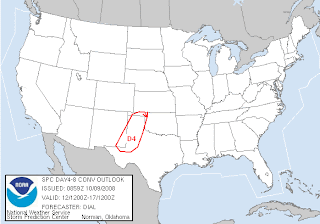

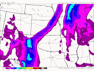
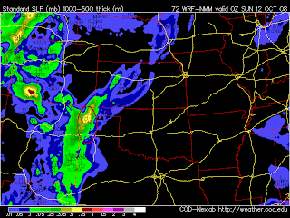 SPC and now the ETA/NAM/WRF models are coming together for a possible weekend of chasing in the Texas Panhandle. Adequate 500mb positively tilted (would like to see negative tilt of course) trough plus 1000 J/kg Cape and helicities off the charts are coming together in the area I've highlighted in red. Haven't been down to the Amarillo house in awhile so this would be a good time to check in!
Monday, October 06, 2008
Possible chase on Saturday Oct 11th?
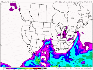
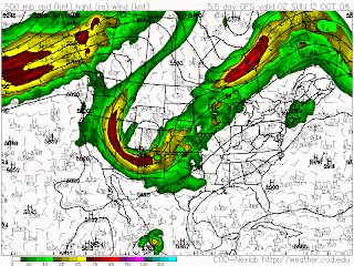 Well yesterday and today didn't have the dynamics to produce any notable severe weather but the GFS is hinting again at a possible chase day next weekend. We'll be watching the models and see if everything can line up for a possible chase day this saturday or sunday.
Wednesday, October 01, 2008
Possible chase on Monday Oct 6th?
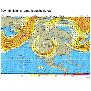
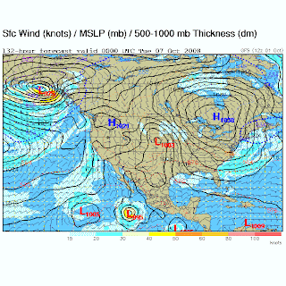 Could this be the first real chase of the fall season? GFS and StormTrack threads are ripe with the possibilities of the breakdown of the summer ridge and a nice deep trough making it's way into the plains on Monday (and possibly Sunday)!
Subscribe to:
Posts (Atom)
The Carlsons', Verne, Michael and Eric

My Blog List
-
-
-
Frasi Di Auguri Di Fine Anno Auguri3 years ago
-
-
-
-
-
-
Odd Season8 years ago
-
Dodge City Monster9 years ago
-
Blog Has Moved10 years ago
-
-
-
Full-Up11 years ago
-
sky drama11 years ago
-
-
Hurricane Sandy11 years ago
-
A Moment in Time....11 years ago
-
-
Replacing the Free Site with Free Trials12 years ago
-
A few thoughts12 years ago
-
New York Mammatus12 years ago
-
test image12 years ago
-
-
NEW BLOG -- Update Link14 years ago
-
NEW BLOG14 years ago
-
Sams Storm Blog has moved!15 years ago
-
A World of Hurt15 years ago
-
March 28th Tornado Chase17 years ago
-
-
-
-
-
-
-
-
-
-
-
-
-
-
-
-
-
-
-
-
-
-
-
-


