Live Geo-referenced Storm Chaser Video. First in the Field Aerial Live Streaming and Aerial Storm Intercepts. High Resolution Level II Radar Data. Severe Weather Forecasts and Reports by Storm Chasers/Severe Weather Videographers Verne, Michael and Eric Carlson. For live stream and video licensing contact us at: vernecarlson@hotmail.com

KRDO ColoSprgs Storm Chasers!

KRDO

KAKE Wichita Storm Chase Team!

KAKE

Denver's Channel 7 Storm Chasers

KMGH 7 News

License this Live Stream Now!

Follow us LIVE on iMap Tracker! When you see a car we are live.


Friday, March 31, 2006

Missed this tornado by 10 minutes on March 30th!


IN MARION COUNTY A TORNADO WAS ON THE GROUND FOR APPROXIMATELY 6 MILES WITH A DAMAGE PATH THAT WAS 200 YARDS WIDE. THE TORNADO WAS RATED AS AN F1 ON THE FUJITA SCALE. THE TORNADO INITIALLY TOUCHED DOWN ABOUT 4 MILES SOUTHWEST OF DURHAM THEN MOVED NORTHEAST. APPROXIMATELY 3 MILES NORTHWEST OF DURHAM SEVERAL OUTBUILDING WERE DAMAGED OR DESTROYED. DEBRIS FROM ONE OF THE OUTBUILDING STRUCK A HOUSE AND DAMAGED IT AS WELL. THE TORNADO LIFTED ABOUT 2 1/2 MILES NORTH OF DURHAM. THAT WAS THE LOCATION WHERE IT KNOCKED A CAR OFF OF K-15 AND A PERSON IN THE VEHICLE WAS INJURED.

Photo copyright Henry Diehl

Potential Chase Day Saturday April 1st


So this afternoon Tony L. called and said "well SPC has done it to us again!" and yes they have! Tomorrow has a moderate risk along with a 45% hatched area for severe weather. I breify checked the ETA and liked everything I saw except for the 500mb winds. They seem rather weak to me for an outbreak of tornadoes. I'll have to check the other models to see if it was only the ETA.

Right now the plan is to stay up till 11pm and see what the Day 1 outlook is like. Then I will get up early-squirrley in the morning and make my decision after checking the surface obs. Michael had his car broken into again at the park and ride last night so he is recovering from his Florida trip, our trip to NE and KS weds and thurs. He would not be able to join me on Saturday so that plays into my decision to go or not. It is sure nice to have his company in the car and to have someone to share in the long haul drives back to Denver!

I'll be making my go/no go decision as late as 6am Saturday morning. I'm currently at 50% going.

Dodge City AFD:
DEWPOINTS COULD BE AROUND 60 BY6 PM SATURDAY WITH A DRYLINE SETTING UP FROM LIBERAL TO GARDEN CITY.A LEAD SHORTWAVE TROUGH WILL MOVE INTO WESTERN KANSAS ON SATURDAYAFTERNOON WITH INCREASING MID LEVEL WINDS AROUND 50 KNOTSOVERRUNNING THE DRYLINE WITH SURFACE WINDS FROM THE SOUTH TOSOUTHEAST AT 20 TO 30 MPH PROVIDING FOR STRONG LOW LEVEL SHEAR FORSUPERCELL DEVELOPMENT AND THE POTENTIAL FOR SOME TORNADOS. NEGATIVEFACTORS ARE IF THERE IS LOTS OF MID AND HIGH CLOUDS AROUND TO KEEPINSOLATION DOWN OR IF AN MCS DEVELOPS NORTH OF THE AREA ALONG A WARMFRONT. WILL INCREASE POPS FROM 20 BY LATE AFTERNOON TO AROUND 60 INTHE EAST ON SATURDAY NIGHT. THE THUNDERSTORMS WILL END FROM WEST TOEAST BY AROUND MIDNIGHT.

Thursday, March 30, 2006

Interesting storm features noted.

Chase day done!

Heading out to our next destination. Denver! Well today looked like it had a lot of potential but the theme for the day was squall lines. Everything went linear as soon as it built and very few cells ever stayed discrete long enough for us to catch up to them. We started the day in York, NE, headed southwest into Kansas and spent most of the day trying to play catch up. Was still a fun chase and as you can see by the pictures below we saw alot of great storms!

Total mileage: 15oo miles

Latest image from Verne's mobile picture phone.

Latest image from Verne's mobile picture phone.

Latest image from Verne's mobile picture phone.

Heading out to our next destination. Red Cloud, NE

PDS Tornado Watch just issued for our area and south!


URGENT - IMMEDIATE BROADCAST REQUESTED TORNADO WATCH NUMBER 109 NWS STORM PREDICTION CENTER NORMAN OK 845 AM CST THU MAR 30 2006 THE NWS STORM PREDICTION CENTER HAS ISSUED A TORNADO WATCH FOR PORTIONS OF CENTRAL AND EASTERN KANSAS SOUTHEAST NEBRASKA NORTHERN OKLAHOMA EFFECTIVE THIS THURSDAY MORNING AND EVENING FROM 845 AM UNTIL 600 PM CST. ...THIS IS A PARTICULARLY DANGEROUS SITUATION... DESTRUCTIVE TORNADOES...LARGE HAIL TO 3 INCHES IN DIAMETER... THUNDERSTORM WIND GUSTS TO 80 MPH...AND DANGEROUS LIGHTNING ARE POSSIBLE IN THESE AREAS. THE TORNADO WATCH AREA IS APPROXIMATELY ALONG AND 100 STATUTE MILES EAST AND WEST OF A LINE FROM 35 MILES NORTH NORTHEAST OF GRAND ISLAND NEBRASKA TO 30 MILES SOUTHWEST OF TULSA OKLAHOMA. FOR A COMPLETE DEPICTION OF THE WATCH SEE THE ASSOCIATED WATCH OUTLINE UPDATE (WOUS64 KWNS WOU9). REMEMBER...A TORNADO WATCH MEANS CONDITIONS ARE FAVORABLE FOR TORNADOES AND SEVERE THUNDERSTORMS IN AND CLOSE TO THE WATCH AREA. PERSONS IN THESE AREAS SHOULD BE ON THE LOOKOUT FOR THREATENING WEATHER CONDITIONS AND LISTEN FOR LATER STATEMENTS AND POSSIBLE WARNINGS. OTHER WATCH INFORMATION...THIS TORNADO WATCH REPLACES SEVERE THUNDERSTORM WATCH NUMBER 108. WATCH NUMBER 108 WILL NOT BE IN EFFECT AFTER 845 AM CST. DISCUSSION...VIGOROUS TROUGH AND ASSOCIATED WIND MAX WILL BE DRIVING EWD ACROSS THE CENTRAL/SRN PLAINS TODAY. VERY STRONG SHEAR PROFILES COUPLED WITH MLCAPES TO 1500 PROVIDE INGREDIENTS FOR RAPID DEVELOPMENT OF SUPERCELLS ALONG AND EAST OF DRY LINE WHICH CURRENTLY IS LOCATED FROM CENTRAL KS INTO NWRN OK. INITIALLY LARGE HAIL WILL BE PRIMARY THREAT WITH TORNADOES BECOMING INCREASINGLY LIKELY BY EARLY/MID AFTERNOON. AS SURFACE LOW NOW WRN KS MOVES NEWD TOWARD SERN NEB CONVERGENCE WILL ENHANCE POTENTIAL FOR POSSIBLE STRONG TORNADOES BOTH AHEAD OF LOW AND DOWN THE DRY LINE INTO NRN OK.

Checking data at a wi-fi hotspot.

Wednesday, March 29, 2006

Day 1 Outlook now posted and it looks favorable!


The Day one outlook is out and it looks very good for our plans tomorrow! We are currently at the Best Western in York, NE just at the nw side of the highest tornado risk area. The plan is to catch the activity near the triple point around noon local and then by 3pm we should have dryline storms firing to our south that we can move on. But hey! We're not greedy!

...SIGNIFICANT SEVERE THUNDERSTORM EVENT IS POSSIBLE ACROSS THE EASTERN PLAINS INTO THE MID MS VALLEY THURSDAY... SRN ROCKIES SPEED MAX IS EXPECTED TO EJECT THROUGH THE BASE OF PLAINS SHORTWAVE TROUGH...ACROSS OK INTO SWRN MO BY EARLY EVENING...ENHANCING LARGE SCALE ASCENT WITHIN STRONGLY DIVERGENT EXIT REGION ACROSS NEB/KS DURING PEAK HEATING. BOUNDARY LAYER AIRMASS IS RECOVERING QUICKLY ACROSS NORTH TX INTO OK LATE THIS EVENING WITH DEW POINTS RISING INTO THE LOWER 60S. THIS AIRMASS SHOULD CONTINUE ADVECTING NWD...WHERE IT ULTIMATELY WILL BE RELEASED IN THE FORM OF SEVERE DEEP CONVECTION BENEATH COLD UPPER TROUGH. LATEST MODEL GUIDANCE CONTINUES TO SUGGEST STRONG WARM ADVECTION WILL FORCE ELEVATED CONVECTION EARLY IN THE PERIOD FROM OK...NWD INTO SRN NEB. THIS ACTIVITY SHOULD SPREAD QUICKLY NEWD DURING THE MID DAY HOURS AS WLY FLOW DEEPENS ACROSS WRN KS INTO THE TX PANHANDLE. VERY STEEP LAPSE RATE PLUME WILL SURGE INTO THE BACK SIDE OF THIS ACTIVITY WITH A NARROW WEDGE OF MODERATE INSTABILITY EXPECTED TO DEVELOP ALONG I-35 CORRIDOR INTO ERN KS/OK. TIMING OF UPPER TROUGH AND THE LACK OF A SIGNIFICANT CAP SUGGEST THUNDERSTORMS WILL INITIATE ALONG WELL DEFINED DRYLINE BY 21Z...POSSIBLY EARLIER IMMEDIATELY AHEAD OF UPPER VORT/SFC LOW OVER SCNTRL NEB.

Getting into position for Thursday's storm chase

Checking data at a wi-fi hotspot. In Salina, KS - after this we are heading north to York, NE where Mike U. and Tony L. have analyzed the situation for tomorrow and overlayed the data from April 10th, 2005 and see alot of similarities! April 10, 2005 was a Cold Core setup where we witnessed numerous tornadoes near Wakeeney, KS.

Latest image from Verne's mobile picture phone. Apparently there are not enough rocks in KS so they import them from Colorado!

Heading out to our next destination. Now entering KS

Heading out to our next destination. Kansas !

Tuesday, March 28, 2006

Weds March 29th Chase Day


I'm liking the area in northwestern KS just east of the surface low where winds back from the east. Tomorrow I have to work my butt off to get out as early as possible and blast east on I-70 to reach my target area!

Sunday, March 26, 2006

Having dinner at the Southern Sun with our nieces!

Latest image from Verne's mobile picture phone. This is Sarah, she's very proud of her picture she drew.

Latest image from Verne's mobile picture phone.

Latest image from Verne's mobile picture phone. This is Anna, she is a great artist and ice skater. Both girls want to learn to snowboard next season!

Latest image from Verne's mobile picture phone.

Thursday Mar 30th Chase Potential

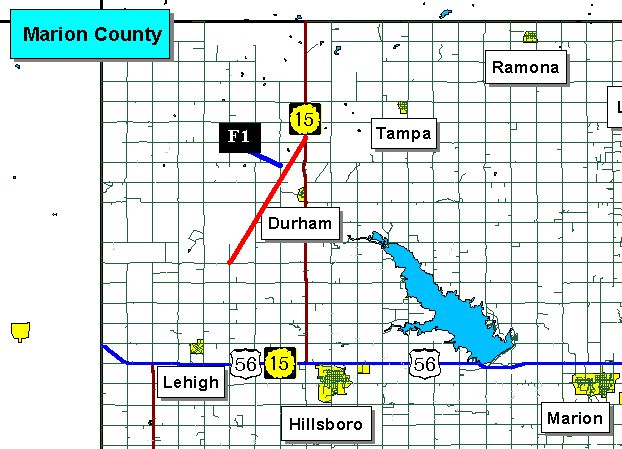
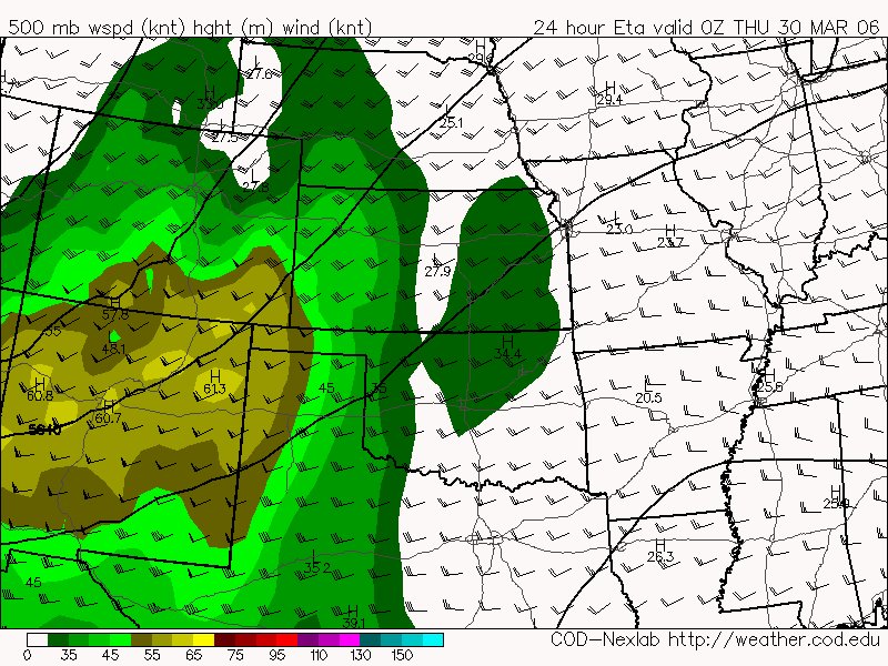
Logging a few of the AFD's arround the area regarding mid-late next weeks chase potential. I have to agree with KC that the unidirectional flow does indicate a squall line for all storms except for those near the surface low where winds may back from the east. Still pretty far away so will have to wait and see.

Oklahoma City, OK

THURSDAY APPEARS TO BE THE BEST DAY FOR STORMS WITH A DRYLINE SETUP AND STRONGER LIFT.


Topeka, KS AFD:
ON THURSDAY H5 TROUGH SWINGS OUT INTO THE PLAINS WITH DRY LINE ACROSS CENTRAL KANSAS THURSDAY MORNING AND MOVING EAST INTO EASTERN KANSAS THURSDAY AFTERNOON. WITH STEEPING LAPSE RATES...FORCING...SHEAR...MOISTURE AND INSTABILITY WILL KEEP CURRENT CHANCES OF THUNDERSTORMS GOING...SOME POSSIBLY SEVERE.

Kansas City, KS AFD:
OTHERWISE THE FOCUS IS ON OUR CONVECTIVE POTENTIAL.ECMWF/GFS/CANADIAN ALL STILL ADVERTISE A WAVE COMING OUT OF THE ROCKIES THURSDAY. WARM AIR ADVECTION AND 
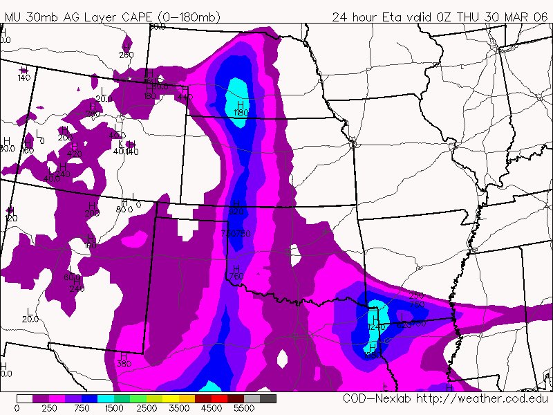
MOISTURE RETURN WILL BE IN FULL SWING AHEAD OF THIS WAVE BY WEDNESDAY NIGHT. GENERAL CONSENSUSIS THAT THE UPPER LEVEL WAVE AND SURFACE LOW WILL LIFT NORTHEAST THROUGH KANSAS AND NEBRASKA...LEAVING US IN THE WARM SECTOR AHEAD OF THE WAVE THROUGH NOON FRIDAY. HOWEVER...BEST LIFT AHEAD OF THE WAVE LOOKS TO MOVE THROUGH THE LOWER MISSOURI RIVER VALLEY THURSDAYAFTERNOON AND EVENING. STILL...FEEL THAT WITH A 100+ KNOT JET EXPECTED TO BE DIGGING UNDER THE WAVE WEDNESDAY THE SYSTEM COULD SLOW UP...THUS PUSHING THE EVENT FROM A THURSDAY/THURSDAY NIGHT EVENT TO A THURSDAY NIGHT/FRIDAY EVENT.THE TRACK OF THE UPPER LEVEL SYSTEM AND SURFACE LOW INDICATES THAT
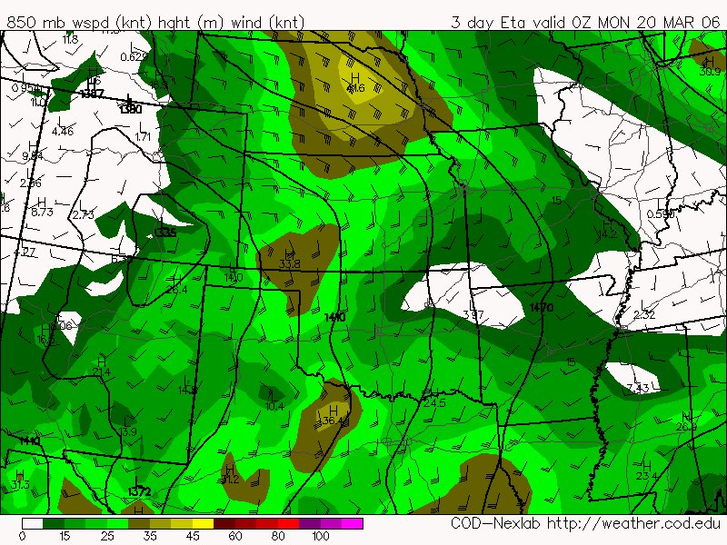
SHEAR PROFILES ACROSS THE REGION WILL BE UNIDIRECTIONAL...FROM THE SOUTHWEST. UNIDIRECTIONAL SHEAR AND SIGNIFICANT MOISTURE FLUX COULD ALLOW FOR STRONG TO SEVERE STORMS AND SQUALL LINES...AS WELL AS TRAINING STORMS. IN THE HAZARDOUS WEATHER OUTLOOK HAVE CONTINUED TO HIGHLIGHT THE BEST POTENTIAL FOR SEVERE WEATHER AS THURSDAY AFTERNOON AND EVENING.

Saturday, March 25, 2006

Chase potential Weds and Thurs next week

Well this originally looked like a Cold Core setup for one or both of these days but looking at this mornings GFS runs I see a more classical synoptic setup. The GFS has the upper level lower broadening out quite a bit and moves the surface low much further north than before. Dewpoints are still rather meager for a more classic setup with only mid 50's available into KS. It's still pretty far out in the future so I have already begun to work this weekend so that I might take off atleast one of the days I need this week to chase this event. I would just use a PTO day but I am really slammed at work right now.

We are only one week away from April and 7 weeks away from my Chase-cation now!

Wednesday, March 22, 2006

These could be fun to chase!

severe weather statement
national weather service pueblo co
217 pm mst day mar 22 2006

...strong dust devils reported in the san luis valley...
at 210 pm...reports from the colorado state patrol indicated strong
dust devils occurring in the san luis valley south of antonito.
radar shows no precipitation in the area...and satellite pictures
only indicate small cumulus clouds in the region. additional dust
devils may occur in the san luis valley...especially the southern
part of the valley...through late afternoon.

Monday, March 20, 2006

Cold core tornadoes in central OK

SPC had a 10% hatched area and tornado watch box out for Louisiana today. But where did the tornadoes form today? Back by the surface low in central OK. At 21Z the surface low was in the OK panhandles with the 500mb low lagging slightly west of it. We had a dry intrusion from the southwest pushing up into a narrow instability axis. As described by Jon Davies, the 0-3Km lapse rates pointed the way to the location of low topped supercells producing a couple brief tornadoes. This underscores the need to keep these cold core setups in our minds and not chase the obvious SPC tornado targets but to look for these subtle clues and never underestimate the potential just east of a strong surface low!

First day of Spring??

Latest image from Verne's mobile picture phone. 6 inches of snow at our house and still coming down. Spring arrives around 11:20am today but you wouldn't know it by looking out our back door!

Sunday, March 19, 2006

Chasing on the edge of Winter

Latest image from Verne's mobile picture phone. A SKIT on a snowstorm! Something I have never seen before. This storm was dumping snow, cuasing lightning and small hail all at the same time!

Mileage for this chase: 290 miles

Latest image from Verne's mobile picture phone. Thunder snow north of Colorado Springs, CO!

Latest image from Verne's mobile picture phone. A nice convective line moves northeast out of the mountains over Colorado Springs, CO. This is the storm that later intensified enough to show the SKIT above.

Latest image from Verne's mobile picture phone. Just east of Colorado Springs, CO we encountered very small hail. I think the term 'Dipping Dots' hail describes it perfectly!

Entering line of showers near DearTrail, CO

Latest image from Verne's mobile picture phone. Heading towards a broken line of weak thunderstorms east of Denver, CO.

Latest image from Verne's mobile picture phone. Storms firing in 57 F/ 37Td air ahead of late winter snowstorm.

Katie B. texted me a message to wake up and look at the MD that had just been issued for eastern CO/NM. So here we are heading out to our next destination. Michael and I heading out east of Denver, CO to intercept a line of storms that fired ahead of a big upper level system bringing snow to Denver.

mesoscale discussion 0317nws storm prediction center norman ok0128 pm cst sun mar 19 2006 areas affected...nern nm and sern coconcerning...severe thunderstorm potential valid 191928z - 192200z chance for widely scattered severe thunderstorms appears to be increasing over parts of nern nm and sern co this afternoon. a fewstorms could produce hail to about 1 inch in diameter.very strong large scale forcing for ascent associated with ageostrophic adjustments within exit region of mid level jet willcontinue to overspread the srn high plains this afternoon.meanwhile...modest surface heating in the wake of high level baroclinic cloud band...coupled with moist upslope flow...were contributing to the development of weak instability across the area.lack of greater moisture is expected to limit mlcape to aob 500j/kg. however...the combination of steep mid level lapse rates andstrong forcing and effective shear should offset the limited instability and aid in the development of scattered low-topped butstrong thunderstorms. a few of these storms could briefly reach severe levels with hail and gusty winds.

Up to 2 1/2 feet of snow coming to the front range of CO

Latest image from Verne's mobile picture phone. We got 2" of snow last night at my house in Coal Creek Canyon, CO. Tonight and into Monday we could get up to 2 1/2 feet! Denver is expecting 8-12" out of this late winter storm.

...LATE SEASON STORM HEADING TOWARD NORTHEASTERN COLORADO....

A STRONG LATE SEASON WINTER STORM CONTINUES TO GATHER STRENGTHOVER THE DESERT SOUTHWEST THIS MORNING. THIS STORM WILL RAPIDLYINTENSIFY BEFORE SWEEPING ACROSS COLORADO TONIGHT. THE WINTER STORMWILL PACK ABUNDANT MOISTURE ALONG WITH GUSTY UPSLOPE WINDS WHICHWILL RESULT IN THE POTENTIAL FOR SIGNIFICANT SNOWFALL ON THENORTHEAST COLORADO BEFORE THE STORM MOVES EAST OF THE AREA MONDAYAFTERNOON. THE HEAVIEST SNOWFALL WILL LIKELY BE IN THE FOOTHILLSAND ADJACENT AREAS INCLUDING THE FRONT RANGE AS WELL AS THE FARNORTHEASTERN PLAINS NEAR THE NEBRASKA AND WYOMING BORDERS.

Saturday, March 18, 2006

Chasing the local storms this weekend

mapquest.com shows the drive from Denver, CO to Midland, TX as over 11 hrs. That is a distance I can simply not make in a day. So.... I'm going to chase the local CO storms that are expected to develop.

From the Puelbo, CO AFD:
For Saturday: THERE IS A SLIGHT CHANCE OF THUNDERSTORMS THIS AFTERNOON AND EVENING OVER MUCH OF SOUTHEASTERN COLORADO. THE MAIN THREAT FROMTHESE THUNDERSTORMS WILL BE LIGHTNING AND SMALL HAIL GENERALLY LESS THAN ONE HALF INCH.

THERE IS A SLIGHT CHANCE FOR THUNDERSTORMS TO DEVELOPSUNDAY AFTERNOON ACROSS PORTIONS OF SOUTH CENTRAL AND SOUTHEASTCOLORADO SUNDAY AFTERNOON AND EVENING. THERE IS A POTENTIAL FORONE OR TWO STRONG THUNDERSTORMS TO DEVELOP ACROSS BENT...KIOWA...PROWERS...AND BACA COUNTIES SUNDAY AFTERNOON AND EARLY EVENING.THE MAIN THREAT FROM THESE THUNDERSTORMS WILL BE HAIL 1/2 INCH ORLESS AND WIND GUSTS TO AROUND 45 MPH.

Friday, March 17, 2006

Saturday's TX chase too far south


Well the Day 1 Outlook is out and the tornado potential is sooo far south as to be unreacheable in a day's drive from Denver. I am however intrigued by the local potential along the southern front range for thunderstorms. I think the plan is to still keep an eye on Sunday's potential in TX but to play the local action in se CO both Saturday and Sunday. I can definately see catching some marginally severe hail and maybe, just maybe a landspout on a boundary near the DCVZ.

The tradeoff with chasing is always that you are willing to go farther and farther out for a better setup. At this time the 5% chance of a tornado "deep in the heart of Texas" is just not enough to draw me that far away in March!

More about local setup if TX looks bleak

Den PM AFD:
on saturday...moisture increases in
the lower levels as well. the low level pressure and wind fields
show decent southeasterly boundary layer flow tonight and saturday
for the plains. this help get the dew points into the 30 to 40 f
range over all the plains by saturday afternoon. there is a decent
theta-e axis across the plains after 21z saturday afternoon. the
cape values are up around 400 joules/kg over the southern plains of
the forecast area by late saturday afternoon. the northeastern
corner has a pretty strong cap at the mid levels...but further west
over the plains...the lapse raters care quite steep. the cross
sections show decent potential instability as well.

regarding saturday evening and again sunday afternoon...model
soundings show the airmass to be quite unstable...so have included
the chance of thunderstorms in each period.

DCVZ Setup coming Saturday??

As typically what happens this time of year is the day before a big snowstorm in March we get a few landspouts east of town due to the DCVZ - watching saturday afternoon for this potential.

From the fri am DEN AFD:

on the plains...rather strong pressure gradient will bring gusty southeast winds across the plains and palmer divide area today. have increased wind speeds in those areas to reflect current obs and expected further increase with daytime heating and mixing. this will also produce a well developed denver cyclone wind regime.


meanwhile sely low winds will increase on sat as sfc low pressure develops over central rockies which may allow for some low level moisture to eventually move into nern co by late aftn. if enough heating occurs appears airmass will become unstable enough for some isold tstms to dvlp by late aftn into the early evening hours main along the urban corridor.

Thursday, March 16, 2006

Potential Chase Day Sunday March 19th


The next potential chase looks to be Sunday March 19th in the Texas Panhandle. A 85kt 500Mb Jet streak rounds into the Caprock area at 0Z. Good southerly return flow and moderate dewpoints. I notice a subtle feature in the surface winds - there's an easterly component in the Turkey - Childress area. This bears watching as the day approaches. Thinking about heading down Saturday afternoon, staying in Amarillo, TX overnight and being in position for Sunday!

The big challenge for this chase will be driving home into the snowstorm that's sure to be raging across eastern CO sunday night!

One-way trip estimate:
------------------------------------
Total Est. Time: 7 hours, 0 minutes
Total Est. Distance: 438.93 miles

Monday, March 13, 2006

First Lightning of the year for Denver, CO!


The storm in the picture below (at 4:31pm) over Louisville, CO went on to create the first lightning of the year for Denver, CO! I counted 6 strikes out of this little cell that could. Very exciting and always a thrill to mark down this first of the season!

As pointed out by Tony L, this baby even has a slight couplet on the velocity scan!

And by the way that's a screen capture off my TV set - all I had for the time being. Okay so with Kathleen's help I got my firewire card and did a real screen capture. Unfortunately all I have on this laptop is Windows Movie maker and it does very low resolution screen grabs. The lightning is very far east of me but never the less it is the first lightning of the year for Denver!

Latest image from Verne's mobile picture phone. Looking a little stormy in Denver!

Latest image from Verne's mobile picture phone. Convective snowshower over Lyons, CO

Sunday, March 12, 2006

Tornado warnings in the Kansas City Metro Area


This area is of particular interest to me since I was just there four days ago chasing!

* AT 211 PM CST...TELEVISION HELICOPTER FOOTAGE SHOWED A FUNNEL CLOUD AND ROTATING WALL CLOUD WITH A VERY SEVERE THUNDERSTORM OVER KANSAS CITY KANSAS. DOPPLER RADAR SHOWED THIS TORNADIC STORM MOVING TO THE EAST AT 45 MPH.

PDS Watch issued earlier today:
URGENT - IMMEDIATE BROADCAST REQUESTED TORNADO WATCH NUMBER 73...CORRECTED NWS STORM PREDICTION CENTER NORMAN OK 1155 AM CST SUN MAR 12 2006 CORRECTED FOR WATCH REPLACEMENTS THE NWS STORM PREDICTION CENTER HAS ISSUED A TORNADO WATCH FOR PORTIONS OF CENTRAL AND WESTERN ILLINOIS EASTERN KANSAS MOST OF MISSOURI EFFECTIVE THIS SUNDAY MORNING AND EVENING FROM 1155 AM UNTIL 1000 PM CST. ...THIS IS A PARTICULARLY DANGEROUS SITUATION... DESTRUCTIVE TORNADOES...LARGE HAIL TO 4 INCHES IN DIAMETER... THUNDERSTORM WIND GUSTS TO 90 MPH...AND DANGEROUS LIGHTNING ARE POSSIBLE IN THESE AREAS. THE TORNADO WATCH AREA IS APPROXIMATELY ALONG AND 105 STATUTE MILES NORTH AND SOUTH OF A LINE FROM 30 MILES WEST OF EMPORIA KANSAS TO 35 MILES SOUTH OF DECATUR ILLINOIS. FOR A COMPLETE DEPICTION OF THE WATCH SEE THE ASSOCIATED WATCH OUTLINE UPDATE (WOUS64 KWNS WOU3). REMEMBER...A TORNADO WATCH MEANS CONDITIONS ARE FAVORABLE FOR TORNADOES AND SEVERE THUNDERSTORMS IN AND CLOSE TO THE WATCH AREA. PERSONS IN THESE AREAS SHOULD BE ON THE LOOKOUT FOR THREATENING WEATHER CONDITIONS AND LISTEN FOR LATER STATEMENTS AND POSSIBLE WARNINGS. OTHER WATCH INFORMATION...THIS TORNADO WATCH REPLACES SEVERE THUNDERSTORM WATCH NUMBER 69...SEVERE THUNDERSTORM WATCH NUMBER 70...SEVERE THUNDERSTORM WATCH NUMBER 71...SEVERE THUNDERSTORM WATCH NUMBER 72. WATCH NUMBER 69 70 71 72 WILL NOT BE IN EFFECT AFTER 1155 AM CST. DISCUSSION...RAPID DEVELOPMENT OF SUPERCELL THUNDERSTORMS WILL OCCUR EARLY THIS AFTERNOON AHEAD OF A PARTICULARLY INTENSE UPPER TROUGH AND JET STREAM MOVING INTO CENTRAL U.S. IN ADDITION TO VERY LARGE HAIL...THERE IS THE POTENTIAL FOR DAMAGING LONG TRACK TORNADOES LATER THIS AFTERNOON AND EVENING. STORMS WILL INITIATE VICINITY OF DRY LINE ERN KS AND ADDITIONALLY VICINITY WARM FRONT EXTENDING EWD ACROSS MO INTO IL.

The Carlsons', Verne, Michael and Eric

The Carlsons', Verne, Michael and Eric

Contact Me for Helicopter Shots!

Flying Monkeys

My Blog List

Blog Archive