Live Geo-referenced Storm Chaser Video. First in the Field Aerial Live Streaming and Aerial Storm Intercepts. High Resolution Level II Radar Data. Severe Weather Forecasts and Reports by Storm Chasers/Severe Weather Videographers Verne, Michael and Eric Carlson. For live stream and video licensing contact us at: vernecarlson@hotmail.com
License this Live Stream Now!
Follow us LIVE on iMap Tracker! When you see a car we are live.

Monday, December 31, 2007
Amarillo, TX Chase Base
Wednesday, November 28, 2007
Extreme Tornadoes 2007 Panhandle Insanity DVD Video!

Just released is our all new highlights video from 2007 with 1 hour and 38 mins of tornado action. This year we were able to capture 32 tornadoes, a personal record for a single season. All of the best High Definition video is on this one DVD. Including two rare wedge tornadoes up close and a chapter on the historic Greensburg Kansas EF5 tornado. Click the link on the right to order your copy through Ebay or use the Buy Now button above!
Below are some actual screen captures from the
March 28, 2007 Beaver County, OK Tornadoes Segment!
Below are actual screen captures from
the Cactus, TX wedge tornado from April 21, 2007 Segment.
Sunday, November 11, 2007
KAP in action


Just tried out the KAP for the first time. It works great! The kite has no problem lifting the 17oz camera rig. The winds for this flight were light at maybe 5-10Kts. I got the rig up to about 100 feet, snapped off 50 shots or so and then brought it back in.
This setup will be ideal for areas were I have to overfly crowds or want to get in pretty close as I can hover the setup over the area I want and shoot at will.
Saturday, November 10, 2007
WW3 Ducted Fan Version
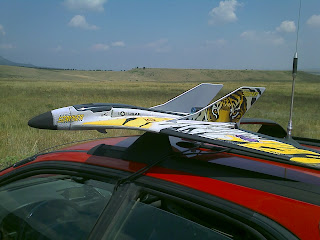
The Wicked Witch 3 RC Tornado Jets are Radio Control Stryker Jets specially modified to have a payload bay added to the underside of the fuselage so that they can carry either an ActionCam flash memory camera or my own custom video downlink for real-time video broadcast to our video goggle pack during flight. I have five of these planes for the 2009 season and they will be sacrificed into a tornado to obtain never before seen video of a tornado approach from the air.
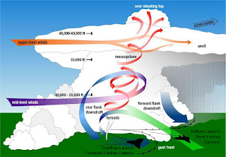
There are two versions of the WW3 and video downlink camera. One is a front view that can be used for a direct flight into the tornado and a second is a rear view camera that can be used to have the plane pace in front of the tornado for some time before going in. Depending on where we are located in relation to the supercell, either the Rear Facing version or the Forward Facing version will be launched.
The idea is to 'kite' the plane in the mean flow and maximize the time before the plane encounters the most violent part of the tornado and is torn apart.
Wingspan: 37"
Weight w/o payload: 22oz
Max payload: 9oz
Typical camera weight: 6oz
Video downlink: 380 scanlines, 3500mW, 3/4 mile range
ActionCam: 640x480 res, 1 hour video record time
Takeoff: Hand-launch
Speed: 60-80mph (one WW3 is outfitted with a max airspeed logger)
FAA allowed ceiling: 400 feet
Recovery: Roadside belly landing in grass

I removed the 1880kV prop motor that comes stock with Stryker Jet and added a 3800kV ducted fan motor - wow what a blast, literally! this will do two things for me, first there is no prop to interfere with the video out the back view and second I can more easily handle these things as there is now no prop to accidentally stick your fingers in.

The Wicked Witch 3 jets are hand launched and flown as conventional RC aircraft but then I flip down the video goggles and I am flying 'virtually' in the cockpit! From these goggles I will be seeing exactly where the plane is going and maintain the tornado in the field of view for the entire flight.
March 2, 2008 Central Oklahoma. Two test flights of the WW3 can be seen in Eric's video. The first with wireless downlink and the second using the ActionCam. The WW3 can be hand-launched in minutes, can land in any grass area near the road and performs very well in high winds.
Aug 22, 2007 Nebraska/Colorado Border. Minutes after this severe warned storm dropped golfball hail we got out ahead of it in the outflow and captured this video of the rainshaft and lightning strikes from the WW3's onboard camera. The curling of the rainshaft as it hit the ground (microburst) was a feature we could not see from the ground and only saw after reviewing the video.
March 30, 2008 Sayre, OK - On the way to chasing tornadoes in central OK we came upon this controlled grass fire burn. I took the opportunity to put my Wicked Witch RC Video Jet up into the action! I think this video most accurately portrays what the view will be like when we get our first deployment into a tornado!
 On May 22, 2008 I lost a Wicked Witch RC Video Plane into the large cone tornado south of Collyer, KS. This plane has been found!
I had been having trouble locking in the wireless video signal so with the tornado approaching from the west I quickly mounted an ActionCam flash memory camera on the plane and flew it out towards the tornado. The plane got into the inflow and I lost sight of it under the dark rainfree base. I called to the group to help me spot it in the air. We saw it a couple of times but then it dissapeared under the RFB in front of the tornado. Whether it actually went into the tornado - only the video onboard could tell.
Three weeks later while planting Milo, Steve Ziegler in Kansas found the Wicked Witch! It was lying in a field 6 miles south of Collyer, KS - roughly where I lost it. I quickly called him back and asked him to describe how it looked and was there a large black cigar shaped camera on the bottom?? NO CAMERA... the nose had been broken off but no camera. The camera was never found. Hopefully in 2009 I can get another chance to pilot an RC airplane into a tornado!
Notice: This is a hobbyist project operating under the flight rules for Model Airplane Aviation as described in FAA advisory circular AC91-57: document here
Tuesday, November 06, 2007
Comet Holmes


Comet Holmes is visible in the northeast sky from my home in Coal Creek. It appears as a fuzz ball to the naked eye in the constellation Perseus.
Sunday, November 04, 2007
KAP rig
Friday, November 02, 2007
KAP (Kite Aerial Photography)

Flowforms have deeper cells and pressure-relieving vents. Easy to inflate and launch in light winds, they’ll fly in stronger winds than other foils. Almost indestructible, they’re made of ripstop nylon reinforced with parachute tape. All sizes have four cells and include a nylon case and a free drogue tail. 6 to 30 mph winds. 6´ x 5.´ 11˝ x 15˝ case. Use 200-lb. Dacron line. Assorted colors.

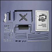
Designed by Kite Aerial Photography pioneer Brooks Leffler, this KAP kit gives you the ability to take pictures from the sky. With the availability of affordable, lightweight, digital cameras, KAP is a rapidly growing hobby.
• Holds a camera up to 5.5” x 4” x 5.5”
• Designed to work with Futaba/Tower radio-control equipment.
• Aluminum, it weighs about one pound.
• Includes a 20-page instruction manual.
• Assembles in 4 to 6 hours with basic hand tools and an electric drill.
Prices:
Kodak M873 8mp camera $189
Brooxes KAP Kit $50
Flowform 30 Kite $199
Line, Hoop, etc $39
Futaba 6 channel Radio $250
---------------------------
Total $727
I purchased my components here
Sunday, October 21, 2007
Friday, October 19, 2007
Thursday, October 18, 2007
Aerial Survey of Greensburg, Kansas
 It's been almost six months since May 4th when at 9:55pm CDT an EF5 tornado destroyed 95% of the structures in Greensburg, KS.
On Weds Oct 17th, 2007 we took the following aerial photos from the center of town to document the rebuilding efforts.
This is the view looking west out towards Dodge City along HW54, west Greensburg is in the foreground.
 In this picture we see Bay, Grove and Walnut Streets south of HW54. As you can see many of the blocks are empty with only the house pads remaining.
 Spruce Bay and Grove Streets on the west side of Greensburg.
 In the upper right a house still has tarps on the roof with large sections missing. The red car on the lower left is Michael, Eric and I from our launch point of the WW5 Digital Camera Plane.
  Here debris piles are on the street and house pads and foundation holes are all that remain. A new driveway has been added at the bottom of the picture.
 Along HW54 through the center of town a new Qwik Shop has been built (lower right). Next to it on both sides are damaged buildings including the old Grocery Store. The John Deere dealership has been rebuilt and opened. There is also a motel and welding shop. The Fire and Police department can be seen along the newly paved HW54 in temporary buildings at the upper left.
 An old foundation is dug out but is currently flooded by recent rains on the left. A new foundation is in the center.
 Modular home half sections await their foundation for placement in the upper left. At the bottom is the old driveway of a scraped house.
 New foundations and another modular home being completed. Other lots sit empty. HW54 is on the right.
 Another view of the new foundations and modular homes.
 Again same view of the new foundations and modular homes.
 View of the north side of Greensburg along with Kiowa county state park lake. Many scraped lots remain. Huge cottonwood trees are no taller than 15 feet high and are growing new branches and leaves out of the sides of the trunks.
 In this view we see how rebuilding has allowed the brown roofed house in the center to be placed at an angle on it's lot.
These photos were taken with the Wicked Witch 5 electric powered glider carrying a Nikon 5.1MP Camera. The glider was hand launched from the center of town and flown to an altitude of about 800 feet. This was a test of the system I plan to use in the following springs to document tornado paths and damage on the morning of big events.
Mileage: 1416
Motel Stays: 2
Wednesday, October 17, 2007
Heading back home
Tuesday, October 16, 2007
On our way to KS
Big chase day Weds Oct 17th!
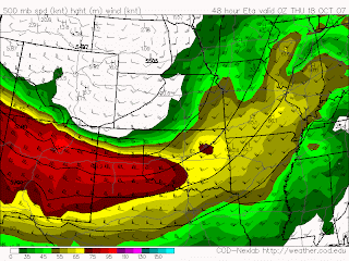

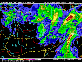 This is nuts! The WRF shows the individual supercells along the dryline in central OK. I don't think I've ever seen that!
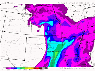
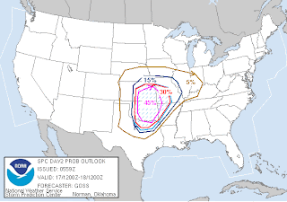
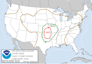
...THERE IS A MDT RISK OF SVR TSTMS ACROSS PARTS OF CENTRAL AND ERN KS...WRN MO...CENTRAL AND ERN OK...NWRN AR...AND PARTS OF N TX... ...THERE IS A SLGT RISK OF SVR TSTMS ACROSS PARTS OF THE CENTRAL AND SRN PLAINS AND INTO THE MID MS VALLEY REGION.... ...SYNOPSIS... LARGE/NEGATIVELY-TILTED TROUGH WILL PREVAIL OVER MUCH OF THE WRN 2/3 OF THE CONUS THIS PERIOD...WITH AN EMBEDDED SHORT-WAVE TROUGH FORECAST TO CROSS THE CENTRAL U.S. AND EVOLVE INTO A CLOSED LOW OVER THE MID MO VALLEY BY THE END OF THE PERIOD. AT THE SURFACE...LOW IS FORECAST TO DEEPEN WHILE MOVING ENEWD FROM WRN KS INTO THE MID MO VALLEY. A SURFACE DRYLINE EXTENDING S FROM THIS LOW SHOULD SERVE AS A FOCUSING MECHANISM FOR AFTERNOON STORMS...WHILE A COLD FRONT DEVELOPS/SHIFTS EWD ACROSS KS AND SEWD ACROSS OK AND THE NWRN HALF OF TX THROUGH THE SECOND HALF OF THE PERIOD. ...PARTS OF THE CENTRAL AND SRN PLAINS INTO THE MID MS VALLEY... SIGNIFICANT SEVERE WEATHER EVENT -- INCLUDING THE POTENTIAL FOR DAMAGING TORNADOES -- IS FORECAST ACROSS THE CENTRAL U.S. THIS PERIOD -- CENTERED OVER PARTS OF KS AND OK. THUNDERSTORMS WILL LIKELY BE ONGOING AT THE START OF THE PERIOD ACROSS PARTS OF THE OUTLOOK AREA...AND MAY PERSIST INTO THE AFTERNOON. THIS PRECIPITATION AND ASSOCIATED CLOUD COVER WILL LIKELY LIMIT POTENTIAL FOR HEATING/DESTABILIZATION ACROSS PARTS OF THE AREA. BY AFTERNOON HOWEVER...MOIST BOUNDARY LAYER COMBINED WITH AREAS OF HEATING SHOULD RESULT IN POCKETS OF DESTABILIZATION...WITH 500 TO 1500 J/KG MIXED-LAYER CAPE LOCALLY EXPECTED BY AFTERNOON. AS UPPER TROUGH APPROACHES FROM THE WEST...CONVECTIVE OUTFLOW OR DIFFERENTIAL-HEATING BOUNDARIES AS WELL AS THE SHARPENING DRYLINE MOVING TOWARD CENTRAL KS/ACROSS WRN OK SHOULD SERVE AS FOCI FOR NEW STORM DEVELOPMENT. GIVEN ROUGHLY N-S DRYLINE AND DISTINCT WLY COMPONENT TO THE MID-LEVEL FLOW -- PARTICULARLY ACROSS OK/N TX...DISCRETE STORM DEVELOPMENT IS EXPECTED. VERY STRONG WIND FIELD IS FORECAST...AS 50 TO 70 KT MID-LEVEL FLOW SPREADS ACROSS THE WARM SECTOR ATOP STRONG SLY BOUNDARY-LAYER FLOW. RESULTING DEEP-LAYER SHEAR SUGGESTS THAT INITIATING UPDRAFTS SHOULD RAPIDLY ACQUIRE ROTATION...WITH SEVERAL SUSTAINED SUPERCELL STORMS LIKELY. ALONG WITH THREAT FOR LARGE HAIL AND LOCALLY-DAMAGING WINDS...LOW LCLS/MOIST BOUNDARY LAYER AND FAVORABLE LOW-LEVEL VEERING/SHEAR SUGGEST THAT MULTIPLE TORNADOES WILL BE POSSIBLE. A FEW OF THESE TORNADOES COULD BE STRONG AND RELATIVELY LONG-LIVED. STORMS SHOULD CONTINUE/SPREAD EWD ACROSS MO/AR AND PERHAPS INTO THE MID MS VALLEY REGION OVERNIGHT. GIVEN MOIST BOUNDARY LAYER AND STRONG MIXING...NOCTURNAL STABILIZATION MAY BE LIMITED ENOUGH THAT A TORNADO THREAT CONTINUES WELL INTO THE OVERNIGHT HOURS AS CONVECTION SPREADS EWD.
The Carlsons', Verne, Michael and Eric

My Blog List
-
-
-
Frasi Di Auguri Di Fine Anno Auguri3 years ago
-
-
-
-
-
-
Odd Season8 years ago
-
Dodge City Monster9 years ago
-
Blog Has Moved10 years ago
-
-
-
Full-Up11 years ago
-
sky drama11 years ago
-
-
Hurricane Sandy11 years ago
-
A Moment in Time....11 years ago
-
-
Replacing the Free Site with Free Trials12 years ago
-
A few thoughts12 years ago
-
New York Mammatus12 years ago
-
test image13 years ago
-
-
NEW BLOG -- Update Link14 years ago
-
NEW BLOG14 years ago
-
Sams Storm Blog has moved!15 years ago
-
A World of Hurt15 years ago
-
March 28th Tornado Chase17 years ago
-
-
-
-
-
-
-
-
-
-
-
-
-
-
-
-
-
-
-
-
-
-
-
-


