Live Geo-referenced Storm Chaser Video. First in the Field Aerial Live Streaming and Aerial Storm Intercepts. High Resolution Level II Radar Data. Severe Weather Forecasts and Reports by Storm Chasers/Severe Weather Videographers Verne, Michael and Eric Carlson. For live stream and video licensing contact us at: vernecarlson@hotmail.com

KRDO ColoSprgs Storm Chasers!

KRDO

KAKE Wichita Storm Chase Team!

KAKE

Denver's Channel 7 Storm Chasers

KMGH 7 News

License this Live Stream Now!

Follow us LIVE on iMap Tracker! When you see a car we are live.


Friday, February 29, 2008

Sunday target moves west


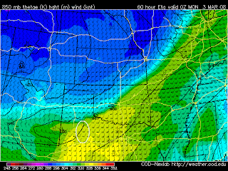
Sunday is now on the ETA/NAM/WRF shorter range model and I'm liking the trend better. Now the target looks to be to the east of Lubbock. Lubbock is only two hours south of my current location in Amarillo, TX so it'll be an easy shot from here. Right now the plan is for Michael and Eric to drive down in Michael's Subie and join me here Saturday night, we would chase to the southeast from here well into Sunday night, spend Sunday night back here in Amarillo and then return to Denver on Monday. That's the plan right now.

Wednesday, February 27, 2008

Sunday March 2 chase potential


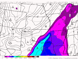
I've been watching Sunday March 2nd for a few days now and am still keeping an eye on it as potentially the first chaseable day in tornado alley. A moderately strong trough overspreads capes up to 1000 J/Kg in the central TX and southern OK region on sunday night. If we were to chase this setup it would be an easy catch from an overnight in Amarillo saturday. Right now it looks like the area west of DFW. We will be keeping an eye on this one. If the trough can deepen and moisture can make it further west then I'd be certainly inclined to chase this one. Have to see what the NAM does with it when it picks it up soon.

FPV Video goggles

Just won a pair of these video goggles on eBay for $114. Normally they go for upwards of $300. These will allow me to easily see out the wireless camera's view from the WW3 while flying and eliminate all glare problems. I will be using a video signal splitter to send the downlink to my laptop for recording and to these goggles for precision pointing while flying. They are being shipped tomorrow and I can't wait to try this new setup!

Friday, February 22, 2008

Almost there!


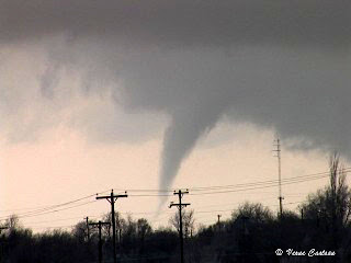
Tomorrow is Feb 23rd when exactly one year ago Michael, Tony and I caught this tornado near McLean, TX in what was our earliest tornado catch ever in the traditional tornado alley.

http://stormchaserco.blogspot.com/2007/02/feb-23-2007-mclean-tx-tornado-chase.html

This year has been record breaking in 'Dixie-alley' but so far nothing has materialized in the panhandles of TX and OK like it did last year. Looking at the GFS there is a hint at moisture making it's way into central TX out on March 3rd. That's a week away so I'll take the time to continue to get ready. I have a few more transmitters to build for the Wicked Witch project so I'll be putting those together.

Wednesday, February 20, 2008

Experiments with streaming video

Inspired by the prospect of live streaming chase video, I set out in an attempt to set up my own video stream, with full control over what the viewer sees.

Click here to view the stream! (Should work with Windows Media Player)

I've successfully set up my own very high quality stream out my bedroom window. What I currently have it zoomed in on is the back of the Lafayette Police Department. If you're lucky you'll be able to see cops walking in and out, or even squad cars with their lights on. But how did I do it? Below is a brief but technical explanation of my setup.

For the video itself, I have my miniDV camcorder hooked up directly to my computer via firewire. This allows for a native 16:9 full resolution picture. I pipe the uncompressed video and audio into a small but very powerful program called VLC media player. It then compresses the video into a streamable size, strips out the audio (I can stream audio, but I don't want to send every noise from my bedroom out to the internet), and broadcasts the resulting picture to the world. Here's the command line used for the stream above:

:sout=#transcode{vcodec=DIV3,vb=512,scale=1,acodec=mp3,ab=128,channels=2}:duplicate{dst=display,dst=std{access=mmsh,mux=ts,dst=:8080},select=noaudio}

This method of streaming allows me to have full control over every aspect of the video, including bitrates, codecs, and more. Plus, I get the added benefit of being able to stream any media I can view on my computer, including video files, dvds, ect.. (Maybe even a live broadcast of a wicked witch flight..;) )

FPV flights

Yesterday at lunch the weather was warm enough for me to attempt my first ever FPV flights. FPV is First Person View, what that means is that after launching the plane I go over to the laptop where the video downlink is recording and fly off the view on the laptop screen. Its a little hairy to look away but I was able to easily control the plane and keep it nice and smooth right off the screen. This will allow me to target exactly where I want to go and video!

Tuesday, February 19, 2008

Getting ready for Chase Season

Today I reactivated wxworx, it always was active but apparently if you don't use it for a few months it will deactivate. A quick call to tech support and it was reactivated.

I now have three GPS pucks to use with wxworx, delorme and stormlab. stormlab 4.0 has spotternetwork integrated in so I'll be able to report severe weather from there this year.

Over lunch I flew my WW3 but this time I flew it off the laptop view. This is know as FPV or First Person View. It puts me 'virtually' in the cockpit and I'm flying as if I were looking out the window. Very cool stuff! More on that later.

Tonight I'm trying out webstreaming, don't know how much I'll stream on chases but it's very simple to setup right here:

http://www.ustream.tv/stormchaserco

Monday, February 18, 2008

2008 National Storm Chasers Conference

This weekend was a favorite of ours - the National Storm Chasers Convention put on by Tim Samaras and the 'incredibly shrinking' Roger Hill. Roger you looked great! I want to start that diet plan! I'm happy to say that we ran the Storms of 20xx booth again this year and raised exactly $1060 for storm victims. It was great to see old friends and make some new ones. In particular I was happy to see Jessie and her mom attend. Jessie is the girl who I've been helping with her questions for her school project this winter.

My favorite talks of the convention were Jon Davies and Mike Umsheids talks about reviewing the past season, Greensburg and forcasting for non-mesocyclone tornadoes. I also enjoyed Tim Marshall's review of the season and the pics of his truck up to it's axles in mud from Silverton, TX Mar 28th this year! Tim Samara's high speed lightning video was amazing as always!

Got to introduce myself to Sean Casey, IMAX filmmaker and desinger of the Tornado Intercept Vehicle. Sean and Josh's banquet speach was a riot, showing the 'reality' of reality TV. I got to show off my Wicked Witch RC airplane project to whoever came by the table. Even I have little idea of what an aerial intercept of a tornado will look like from the air - but I bet it will be amazing!

Sunday, February 10, 2008

Red Star Ridge columns

Hiked up to the base of this sandstone column in PDCSP and even though this thing may stand like this for another thousand years it looked like it was about to fall on our heads! Needless to say we didn't get any closer than this.

Red Star Ridge area of Palo Duro, TX

Had a great weekend of mountain biking and hiking in Palo Duro Canyon State Park again this weekend. There are numerous of these sandstone columns in the canyon.

Friday, February 08, 2008

Texas Longhorn

This guy was feeding at the state park entrance.

Tuesday, February 05, 2008

Super Tuesday Outbreak!

Tony Laubach http://www.tornadoeskick.com/blog.html scored big today with a multi-vortex touchdown and twisty funnel cloud northeast of Memphis, TN. Above is the radar image at the time of the multi-vortex tornado. At this hour there have been 35 tornadoes reported as well as tornado emergencies being declared for a couple cities including Memphis, TN.

Check out his video here: http://www.bnvn.net/blog/images/020508/

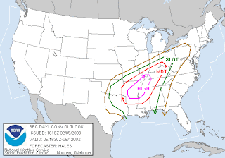
Big outbreak day predicted for the central US!


OVERALL SYNOPTIC SETUP WILL BECOME QUITE FAVORABLE FOR AN OUTBREAK OF SEVERE THUNDERSTORMS AND TORNADOES...INCLUDING LONG-LIVED TORNADIC SUPERCELLS...
EXTREME SHEAR WITH SFC-1 KM SRH IN EXCESS OF 300 M2/S2 SUGGESTS STORMS WILL RAPIDLY DEVELOP ROTATION AND AN ATTENDANT TORNADO THREAT ONCE THEY ROOT INTO DEEPLY MOIST BOUNDARY LAYER. ANY TORNADIC SUPERCELLS COULD PRODUCE A LONG-LIVED SIGNIFICANT TORNADO IN THIS ENVIRONMENT.


Friday, February 01, 2008

Gropple and Thundersnow in Denver!


A crazy night in Denver! After doing our interview this evening and flying the WW3 in very cold conditions lightning net lit up as a low topped storm showing up to 50 dbz moved southeast over Denver. I counted at least 3 lightning strikes from this storm and as you can see above it was very isolated, north of Denver it's clear out and south there is a summer-like gropple shaft pummelling Denver!

The Carlsons', Verne, Michael and Eric

The Carlsons', Verne, Michael and Eric

Contact Me for Helicopter Shots!

Flying Monkeys

My Blog List

Blog Archive