Live Geo-referenced Storm Chaser Video. First in the Field Aerial Live Streaming and Aerial Storm Intercepts. High Resolution Level II Radar Data. Severe Weather Forecasts and Reports by Storm Chasers/Severe Weather Videographers Verne, Michael and Eric Carlson. For live stream and video licensing contact us at: vernecarlson@hotmail.com
License this Live Stream Now!
Follow us LIVE on iMap Tracker! When you see a car we are live.

Wednesday, December 31, 2008
Carlson Chasers Blog selected as one of the 100 Best Blogs for Earth Science Scholars
The Carlson Chasers Blog has been selected in the top spot for Meteorology Blogs in this list of 100 Best Blogs for Earth Science Scholars! Check out the whole list here: 100 Best Blogs
Tuesday, December 30, 2008
Saturday, December 27, 2008
Birthday Chase 12-27-08


My Brother and I decided to chase down in Northern Texas today and last night. We basically pulled an all nighter, well I did for the most part because I drove from Denver all the way to the target in Gainesville Tex. I will total up the mileage latter but I know I managed to get over 1000 miles so far and we are heading back to Amarillo, Tex. This late December chase was amazing and probably the best Bday present I could receive!
Michael C.
Early AM Chase in OK/TX
Friday, December 26, 2008
Michael and Eric chasing tornadoes across eastern Oklahoma today!
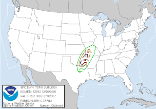
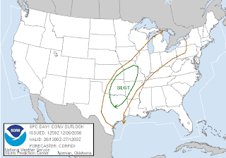 Michael and Eric made the trip last night to our Amarillo chase base and today they will be in good position to chase the 10% hatched risk of tornadoes in eastern Oklahoma today!
...SRN AND CNTRL PLNS/OZARKS...
AHEAD OF APPROACHING UPR TROUGH...50-60 KT SSWLY LLJ FROM E TX INTO
MO/IL WILL SUPPORT CONTINUED STRONG BOUNDARY LAYER MOISTURE
RETURN ACROSS ERN PARTS OF THE SRN PLNS AND OZARKS...WITH 60 DEG F
SFC DEWPOINTS EXPECTED AS FAR N AS CNTRL MO BY EARLY SATURDAY.
ALOFT...STRONG SWLY MID AND UPR LVL FLOW EXPECTED TO FURTHER
STRENGTHEN AND SLIGHTLY BACK DURING THE PERIOD. 500 MB SPEEDS AOA
60 KT ARE EXPECTED THIS EVENING OVER CNTRL/ERN OK AND MO...WITH
WINDS INCREASING TO AROUND 80 KTS EARLY SATURDAY.
POSITIVE TILT OF UPR TROUGH WILL KEEP MID LVL LAPSE RATES
COMPARATIVELY WEAK. NEVERTHELESS...COMBINATION OF SUSTAINED
WARM/MOIST ADVECTION...WEAKLY CONFLUENT LOW LVL FLOW...AND WEAK
HEIGHT FALLS AHEAD OF APPROACHING UPR TROUGH EXPECTED TO SUPPORT
DEVELOPMENT OF A CONCENTRATED BAND OF TSTMS EARLY TONIGHT ALONG WRN
EDGE OF LLJ/MOIST AXIS FROM CNTRL MO SW ACROSS FAR NW AR INTO ERN
OK.
WITH THE INITIAL ACTIVITY OCCURRING IN A HIGHLY-SHEARED ENVIRONMENT
AWAY FROM STRONG LOW LVL LINEAR FORCING...SETUP SHOULD SUPPORT A FEW
ELONGATED...QUASI-DISCRETE SUPERCELLS. QUALITY OF MOISTURE INFLOW
AND 25-30 KT 0-1 KM SHEAR SUGGEST POTENTIAL FOR A FEW TORNADOES...IN
ADDITION TO BOWING SEGMENTS WITH HIGH WIND...DESPITE WEAK MID LVL
LAPSE RATES. WITH TIME...STORM MODE MAY BECOME MORE COMPLEX AS
ASSOCIATED COLD POOLS ELONGATE AND MERGE. BUT A CONTINUED THREAT
FOR SVR WEATHER...INCLUDING POSSIBLE TORNADOES...LIKELY WILL
CONTINUE THROUGH DAYBREAK SATURDAY.
FARTHER W...ANOTHER BAND OF STORMS MAY FORM AFTER 06Z FROM SE KS SSW
THROUGH CNTRL OK INTO N CNTRL TX AS AFOREMENTIONED COLD FRONT
ACCELERATES SEWD. THIS ACTIVITY MAY POSE A THREAT FOR SVR HAIL...IN
ADDITION TO HIGH WIND AND PERHAPS A TORNADO...AS IMPULSE NOW OVER NV
EDGES E TOWARD REGION.
Tuesday, December 16, 2008
Tornadoes captured by TV News Copters
August 25, 2008 Parker, CO
May 24, 2008 Hennessey, Oklahoma
April 24th 2006, Tornadoes Oklahoma City - El Reno
October 4, 2004 near Denver International Airport
July 18, 1986 Brooklyn Park, Minnesota
These are the ones I could recall and find on YouTube. If anyone can think of any others please comment!
May 24, 2008 Hennessey, Oklahoma
April 24th 2006, Tornadoes Oklahoma City - El Reno
October 4, 2004 near Denver International Airport
July 18, 1986 Brooklyn Park, Minnesota
These are the ones I could recall and find on YouTube. If anyone can think of any others please comment!
Tuesday, December 09, 2008
Foot of snow!
Last night we got a foot of snow. This was the first time I had to fire up the snowblower. On our way into the office now.
Sunday, December 07, 2008
Carlson Chasers Season 2008 DVD now on TVN
Eric's awesome DVD of our 2008 season is now available on the TornadoVideos.Net store!
http://tornadostore.net/index.php?main_page=product_info&cPath=3&products_id=215
http://tornadostore.net/index.php?main_page=product_info&cPath=3&products_id=215
Friday, December 05, 2008
Ground blizzard
This morning it was a challenge to get into work with the sun in your eyes and a ground blizzard across the road. This in on hw72 almost to hw93.
Saturday, November 29, 2008
Hangin in Hays
$1.58 gas in Hays KS. We are out in Kansas today knocking off the list of things to do on the Russell, KS chase base. Its looking good and ready for next spring!
Things still to do:
- Plumber to open up the bathroom drain.
- White paint for kitchen trim and closet door.
- Liquid nails for kitchen thresholds.
- Stain the front deck.
- Hunter Green trim on the outside doors and windows.
- Insulating strip on the back door.
- Back room window locks.
- Horizontal mini-blinds for bathroom.
- Clock radios in all bedrooms.
- Sand down and then retape some cracks around the interior doorways. Repaint with tan.
Monday, November 24, 2008
Russell Kansas Chase Base - Things to do
This Friday, Amanda and I are going to head out to Russell, KS and get some work done on the house. I'm making a list here so that I am sure to buy all the supplies for the trip. The only critical things are the plumbing. Everything else is 'nice-to-have'. I want to get these things done now so that I don't have them to do next spring when things get crazy again!
- Replace the kitchen drain trap in the crawlspace. It froze last winter and when it was turned on this fall all the water from the kitchen sink ran into the crawl space.
- Unclog the bathroom sink drain. Somewhere beyond the trap there is a clog keeping the sink from draining. I have a hand-crank snake to hopefully unclog it. If this doesn't work I may rip the entire drain line out and rebuild it with PVC.
- Stain the front deck. Bought some clear deck stain already.
- Paint the front door. The door was exposed to the elements before previous owner added the storm door. Got a can of green paint already.
- Setup the 2nd bedroom timer lamp.
- Install exterior spigot covers. Need to still buy these. * bought
- Bring the weather alert radio and install it in the kitchen.
- Bring the US wall map in the office to put up in the house.
- Attempt to mow the backyard. The grass may have dried up enough now to push the mower through the jungle of high grass.
- Sand down and then retape some cracks around the interior doorways.
- Bedroom closet door is sticky. Trim it down so it fits again.
- Measure for the kitchen floor thresholds.
Thursday, November 20, 2008
Fog over Denver
 We get nights like this only a few times a year when we can see over the top of the fog below. The picture may not capture it well but you can see the lights of Denver shining up from below the cloud layer.
Thursday, November 13, 2008
Chinook Winds along hw93
The Chinook Winds are blowing hard along hw93 this morning. Toppling this old dead pine tree. Verne Carlson
Wednesday, November 12, 2008
Favored Chase Areas Map
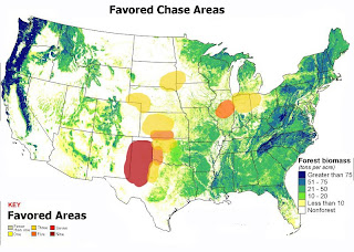 Tallying up the number of mentions on a recent stormtrack.org thread - I came up with this map for favored chase areas of the country. No surprise that the Texas panhandle and caprock region was the overwhelming winner. Surprised that no one mentioned eastern Colorado but maybe that should have been my job.
Sunday, November 09, 2008
Carlson Chasers Season 2008 DVD!

Our 2008 DVD is now available for purchase! Includes 2 hours of non-stop severe weather footage!


Includes full chapters of:
March 2
March 30
April 23
May 22
May 23
May 25
May 29
As well as an additional half-hour of nothing but assorted weather footage from this year!
Purchasing information can be found by clicking the "Buy Now" link here!
Thursday, November 06, 2008
Severe weather possible next Sunday!
 SPC has next sunday and monday as severe days in Texas. I checked the GFS and see the trough but no cape on those days. The trough doesn't look particularily deep so will have to see. Will note it here and be watching it for a possible trip to Amarillo on Sunday!
Edit: 84hr out NAM is showing a tonge of 1000J/kg cape up into the Wichita Falls, TX area on sunday night. I'll be watching over the next couple days. If that can move back west into the TX panhandle I might bite!
CONFIDENCE IS INCREASING THAT CONVECTIVE
DESTABILIZATION WILL BECOME MORE THAN SUFFICIENT...IN THE PRESENCE
OF STRONG DEEP LAYER SHEAR AND FAVORABLE LARGE-SCALE FORCING FOR
UPWARD VERTICAL MOTION...FOR ORGANIZED SEVERE STORM
DEVELOPMENT...INCLUDING A FEW SUPERCELLS... ACROSS PARTS OF WESTERN
AND NORTHWEST TEXAS BY SUNDAY NIGHT.
Wednesday, November 05, 2008
Tornadoes possible in Kansas/Oklahoma today
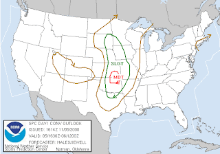
 Tornadoes are possible today in a small area and timeframe on the eastern KS/OK border. RUC is showing 2000J/kg2 Cape at 0z over the Wichita area and with ample shear rotating storms and tornadoes are expected. I opted to sit this one out as I believe the narrow window of daylight and the chase terrain are not ideal. Still I would've loved to have given it a shot. The distance away would've meant a stay at Russel before and after and still a 5 hour drive to the target from there. Good luck everyone who is out there!
ANY DISCRETE SUPERCELL WILL
HAVE GREATEST POTENTIAL FOR TORNADOES AS THEY TRACK NEWD ACROSS SERN
KS/NERN OK THRU THIS EVENING. THERE IS THE POTENTIAL FOR LONG LIVED
SUPERCELLS INCLUDING POSSIBLE STRONG TORNADOES AS THEY TRACK THRU
MOISTURE/INSTABILITY AXIS THIS EVENING DUE TO ENHANCED LOW LEVEL
SHEAR IN THE VICINITY OF SECONDARY SURFACE WAVE. SUPERCELL
DEVELOPMENT POTENTIAL WILL EXTEND SWD ALONG DRY LINE INTO CENTRAL OK
BY 00Z.
Tuesday, November 04, 2008
Late season severe chances - but I'll sit this one out


Still mulling things over for a chase on Weds. Pluses are that everything looks like it will be in place for severe weather. Even with the early sunset of 5:45pm CST it looks like there will be ample CAPE and erroded cap by 3-4pm so that we'll have a couple hours of storms before dark. Also on the plus side is that since this is a pacific front there won't be a raging blizzard on the backside to content with. Gas is reasonable at $2.29/gal but I have to take the Exped so that negates the cheap gas!
Minuses right now are the distance east with most targets starting at I-35 and going east from there. Right now I'm about 50-50 on going. I have all my gear in the car and will decide after the 12z NAM model run.
EDIT: after the latest NAM run the dryline is moved even farther east of I-35. The latest SPC day 2 also cut back on the 30% severe area and expects that a squall line will develop. Given that, I'm going to sit this one out. It is November afterall and not May!
Wichita AFD from this morning:
WED & WED NIGHT:THESE CONTINUE TO BE 2 MOST VOLATILE PERIODS OF FORECAST. WITH UPR-DECKTROF ASSUMING MORE NEGATIVE TILT AS IT DIGS FURTHER OVER SRN ROCKIES...UPR DIFFLUENCE WILL INCREASE WED WITH STRONG(!) SWLY UPR-DECK FLOW (500MB WINDS OF 50-70KTS) PROGGED TO SPREAD NE ACROSS KS WED AFTERNOON. DEEPLAYER SHEAR IMPRESSIVE BOTH FROM SPEED & DIRECTIONAL STANDPOINTS. WITHPACIFIC COLD FRONT SURGING SE ACROSS KICT COUNTRY WED EVENING SUCH SHEARWILL INCREASE FURTHER. SBCAPES OF 1,000-1,300J PROGGED OVER MOST OF KICTCOUNTRY WED AFTERNOON & WITH STRONG 700-500MB COLD ADVECTION INVADING KSAS MID-UPR LOW VENTURES E ACROSS NRN PLAINS FURTHER DESTABILIZATION ISLIKELY. AS SUCH CONFIDENCE REMAINS FAIRLY HIGH THAT SUPERCELLS WILLDEVELOP OVER AREAS PRIMARILY ALONG & E OF I-135 WED AFTERNOON & EVENING& WITH SUCH STRONG MID-UPR FLOW...SUPERCELLS TO BE FAST-MOVING WITHDAMAGING WINDS OF 60-70 MPH & LARGE HAIL BOTH POSSIBLE. ONLY CHANGESWERE TO INCREASE POPS WED NIGHT OVER SE KS AS CONVERGENCE ALONGAPPROACHING COLD FRONT IMPRESSIVE.
Monday, November 03, 2008
Severe weather a possibility for Weds!
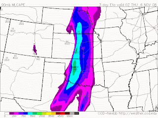
 Weds may see some severe weather in eastern Kansas on Weds. I am keeping an eye on the models and will decide on a go/no-go by Tuesday.
From the Wichita NWS:
WED & WED NIGHT:
THESE 2 PERIODS CONTINUE TO BE MOST VOLATILE OF THIS WEEK. WITH THE UPR
TROF ASSUMING SLIGHT NEGATIVE TILT AS IT CROSSES SRN ROCKIES UPR-LEVEL
DIFFLUENCE WILL INCREASE MARKEDLY OVER THE KICT COUNTRY WED AFTERNOON.
DEEP-LAYER SHEAR WILL THEREFORE BE IMPRESSIVE & THEREFORE SUPPORTIVE OF
A FEW FAST-MOVING SUPERCELLS AS SW 500MB FLOW LIKELY REACHING 50-70KTS.
MID-UPR LEVEL COLD ADVECTION IMPRESSIVE & WILL PROMOTE CONSIDERABLE
DESTABILIZATION. AS SUCH CONFIDENCE IS INCREASING THAT SVR TSRA WILL
ERUPT OVER MUCH OF ERN HALF OF KS WED AFTERNOON & EVENING.
Friday, October 31, 2008
Goodbye Subie
Subie has officially been donated to Goodwill and served me well over 100,000 miles and many chases. Rest well Subie...
Monday, October 13, 2008
DVD: Carlson Chasers Season 2008!

Our 2008 DVD is now available for purchase! Includes 2 hours of non-stop severe weather footage!


Includes full chapters of:
March 2
March 30
April 23
May 22
May 23
May 25
May 29
As well as an additional half-hour of nothing but assorted weather footage from this year!
Purchasing information can be found by clicking the "Buy Now" link here!
Saturday, October 11, 2008
No chasing this weekend - or is there?
Well as expected hurricane Norbert has cast it's influence into the e NM/w TX area and has all but cutoff all chances for the great kinematics to produce tornadoes. There will be a lot of rain and some marginally severe hail but not enough to warrant a trip down to the south. At the house here we are alternating between bright clear skies and low fog rolling in. This could be our first shot at some measurable snow for the 08-09 winter season!
Edit: SPC just put up a 5% tornado risk area for the w OK panhandle. I am seriously considering heading out the door and shooting down there. The vertical sheer today and tomorrow is amazing on the edge of the 110 kt 500mb jet!
Edit 2: Dann you said it - we need sunlight! Now it's 7:15pm MDT and we have a tornado watch for ne NM, must be driven entirely by wind dynamics. Wow STRONG TORNADOES possible:
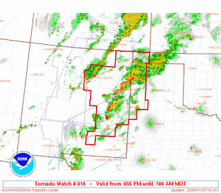
DISCUSSION...SCTD TSTMS/SUPERCELLS EXPECTED TO PERSIST ALONG SSW-NNE
CONFLUENCE ZONE IN E CNTRL/SE NM. OTHER STORMS EXPECTED TO PERSIST
ALONG SIMILAR CONFLUENCE BAND IN MORE DEEPLY-MIXED ENVIRONMENT IN N
CNTRL/ NE NM. STRENGTH OF EXISTING WIND FIELD...LIKELIHOOD FOR SOME
BACKING/STRENGTHENING OF NEAR-SFC FLOW...AND MOIST BOUNDARY LAYER
OVER ERN NM SUGGEST POTENTIAL FOR ISOLD BUT POSSIBLY STRONG
TORNADOES OVER THAT PART OF THE STATE AND IN ADJACENT PARTS OF TX.
HAIL/LOCALLY DMGG WIND WILL REMAIN POSSIBLE WITH STORMS IN THE N
CNTRL/NE NM.
Edit: SPC just put up a 5% tornado risk area for the w OK panhandle. I am seriously considering heading out the door and shooting down there. The vertical sheer today and tomorrow is amazing on the edge of the 110 kt 500mb jet!
Edit 2: Dann you said it - we need sunlight! Now it's 7:15pm MDT and we have a tornado watch for ne NM, must be driven entirely by wind dynamics. Wow STRONG TORNADOES possible:

DISCUSSION...SCTD TSTMS/SUPERCELLS EXPECTED TO PERSIST ALONG SSW-NNE
CONFLUENCE ZONE IN E CNTRL/SE NM. OTHER STORMS EXPECTED TO PERSIST
ALONG SIMILAR CONFLUENCE BAND IN MORE DEEPLY-MIXED ENVIRONMENT IN N
CNTRL/ NE NM. STRENGTH OF EXISTING WIND FIELD...LIKELIHOOD FOR SOME
BACKING/STRENGTHENING OF NEAR-SFC FLOW...AND MOIST BOUNDARY LAYER
OVER ERN NM SUGGEST POTENTIAL FOR ISOLD BUT POSSIBLY STRONG
TORNADOES OVER THAT PART OF THE STATE AND IN ADJACENT PARTS OF TX.
HAIL/LOCALLY DMGG WIND WILL REMAIN POSSIBLE WITH STORMS IN THE N
CNTRL/NE NM.
Thursday, October 09, 2008
Texas Panhandle Weekend Chase?
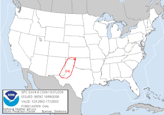

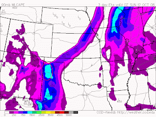
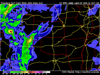 SPC and now the ETA/NAM/WRF models are coming together for a possible weekend of chasing in the Texas Panhandle. Adequate 500mb positively tilted (would like to see negative tilt of course) trough plus 1000 J/kg Cape and helicities off the charts are coming together in the area I've highlighted in red. Haven't been down to the Amarillo house in awhile so this would be a good time to check in!
Monday, October 06, 2008
Possible chase on Saturday Oct 11th?
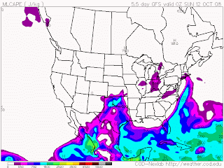
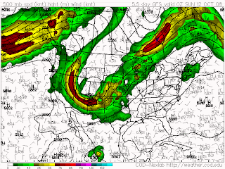 Well yesterday and today didn't have the dynamics to produce any notable severe weather but the GFS is hinting again at a possible chase day next weekend. We'll be watching the models and see if everything can line up for a possible chase day this saturday or sunday.
Wednesday, October 01, 2008
Possible chase on Monday Oct 6th?
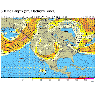
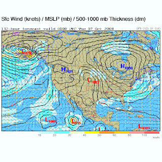 Could this be the first real chase of the fall season? GFS and StormTrack threads are ripe with the possibilities of the breakdown of the summer ridge and a nice deep trough making it's way into the plains on Monday (and possibly Sunday)!
Sunday, September 21, 2008
FPV crash into fence!
I was doing some FPV flying today with the Wicked Witch 3 when I was glitched at low level and crashed into a fence. Luckily I had the recorder running and captured it all on video! The foam wings and fuse will need to be replaced and it will fly again.
Friday, September 19, 2008
Introducing the Flying Monkey Mini Camera Gimbal!
 I've been messing around with video on the Blade 400 for some time, and through several iterations I now have a completely custom gyro stabilized pan + tilt wireless camera. This design allows for the flexibility of our larger heli but with the expendibility and saftey of our wicked witch planes
 This is the camera itself. Mounting it on the front of the heli allows for a good range of motion. It can even point upwards without begin obstructed!
 Here is the control box. The whole assembly is very lightweight and designed to stay well out of the way of the helicopter mechanics.
 The battery is mounted underneath the main rotor. It can power both the camera and the rc system.
The entire assembly. Two people are required to operate the heli and camera. Thankfully, the VR goggle video downlink system from our large camera system is also compatible with this system.
Video coming soon!
Subscribe to:
Posts (Atom)
The Carlsons', Verne, Michael and Eric

My Blog List
-
-
-
Frasi Di Auguri Di Fine Anno Auguri3 years ago
-
-
-
-
-
-
Odd Season8 years ago
-
Dodge City Monster9 years ago
-
Blog Has Moved10 years ago
-
-
-
Full-Up11 years ago
-
sky drama11 years ago
-
-
Hurricane Sandy11 years ago
-
A Moment in Time....11 years ago
-
-
Replacing the Free Site with Free Trials12 years ago
-
A few thoughts12 years ago
-
New York Mammatus12 years ago
-
test image13 years ago
-
-
NEW BLOG -- Update Link14 years ago
-
NEW BLOG14 years ago
-
Sams Storm Blog has moved!15 years ago
-
A World of Hurt15 years ago
-
March 28th Tornado Chase17 years ago
-
-
-
-
-
-
-
-
-
-
-
-
-
-
-
-
-
-
-
-
-
-
-
-
Links
Contributors
Blog Archive
-
▼
2008
(172)
-
▼
December
(10)
- Carlson Chasers Blog selected as one of the 100 Be...
- Chinook aftermath
- Chinook Wind Damage
- Birthday Chase 12-27-08
- Early AM Chase in OK/TX
- Michael and Eric chasing tornadoes across eastern ...
- Tornadoes captured by TV News Copters
- Foot of snow!
- Carlson Chasers Season 2008 DVD now on TVN
- Ground blizzard
-
►
November
(10)
- Hangin in Hays
- Russell Kansas Chase Base - Things to do
- Fog over Denver
- Chinook Winds along hw93
- Favored Chase Areas Map
- Carlson Chasers Season 2008 DVD!
- Severe weather possible next Sunday!
- Tornadoes possible in Kansas/Oklahoma today
- Late season severe chances - but I'll sit this one...
- Severe weather a possibility for Weds!
-
▼
December
(10)


