The storm really intensified as it neared Limon, CO. We met up with Jon M and Shawn along hw71 here.
Storm crosses hw 71 north of Limon, CO. Golfball size hail was reported south of Limon.
Michael and I check out the forward flank shelf cloud with many eddies in it and spinups.
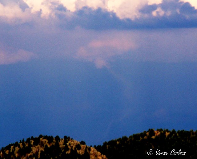
Interesting lowerings on the north side of the storms, we saw this kind of updraft feature a few times today at different locations. We made it out past Flaggler before calling it a night and trying (unsuccessfully) for some lightning shots.
Live Geo-referenced Storm Chaser Video. First in the Field Aerial Live Streaming and Aerial Storm Intercepts. High Resolution Level II Radar Data. Severe Weather Forecasts and Reports by Storm Chasers/Severe Weather Videographers Verne, Michael and Eric Carlson. For live stream and video licensing contact us at: vernecarlson@hotmail.com
License this Live Stream Now!
Follow us LIVE on iMap Tracker! When you see a car we are live.
Thursday, August 31, 2006
Wednesday, August 30, 2006
Severe Storms Thursday Night
Models are showing storms firing over the Palmer Divide and heading east from 5:00pm to 10:00pm at night. Michael and I will be going out and chasing supercells. We should atleast get some good lightning shots!
...CNTRL HIGH PLAINS... WHILE STRONG MOISTURE RETURN DOES NOT APPEAR LIKELY ACROSS THE REGION...MODEST BOUNDARY LAYER MOISTENING WILL OCCUR NEAR LEE-TROUGH AND ADVANCING COLD FRONT FROM SWRN NEB SWD ALONG CO/KS BORDER. SURFACE DEWPOINTS AROUND 60F AND TEMPERATURES CLIMBING THROUGH THE 80S WILL CONTRIBUTE TO MODERATE DESTABILIZATION WITH LAPSE RATES STEEPENING WITH DAYTIME HEATING. MEAN LAYER CAPE ON THE ORDER OF 1500 J/KG IS ANTICIPATED BY AFTERNOON...WHEN FORCING NEAR INTERSECTION OF COLD FRONT AND SURFACE TROUGH/WEAK DRY LINE SHOULD LOCALLY ELIMINATE CAPPING ASSOCIATED WITH ELEVATED MIXED LAYER. WEAK BUT VEERING WINDS WITH HEIGHT FROM LOWER TO MID-LEVELS...BENEATH MODERATE WESTERLY HIGH LEVEL FLOW...SHOULD PROVE ADEQUATE FOR ISOLATED SUPERCELLS WITH HAIL AND HIGH WINDS. ADDITIONAL ACTIVITY WITH SEVERE HAIL POTENTIAL MAY ALSO OCCUR IN RELATIVELY MOIST POST-FRONTAL UPSLOPE FLOW REGIME FROM NEB PNHDL TO THE CO FRONT RANGE.
Sunday, August 27, 2006
August 26, 2006 Eastern CO chase
Eric shoots the storm from Cedar Point, CO as it moves towards us rapidly from the west.
We were hit with incredibly strong outflow winds from this storm, upwards of 60kts!
Street flooding under I-70 at Deer Trail!
Michael films the street flooding up close.
End of the day lightning from the tornado warned cell coming out of Pueblo.
Saturday, August 26, 2006
Tornado warned cell over Pueblo!
Latest image from Verne's mobile picture phone tornado warning! We were thinking that our chase was done when we saw Pueblo go tornado warned and 'We're Gone!'
Thursday, August 24, 2006
Playing around with Photo Borders
Created this digital photo frame in photoshop tonight so that I can frame my favorite pictures. I titled this one "Fan of Fire"
Tuesday, August 22, 2006
Sunday, August 20, 2006
Tornadoes over Bennett, CO!
I just watched and videoed this tornado over Bennett that was visible from all the way up at our house in Coal Creek Canyon (50 miles away - line of site). This tornado was on the ground for up to 5 minutes. Michael and Eric were out chasing today and were able to get much closer shots and video! More pics to come soon!
Tuesday, August 15, 2006
The A-Basin Ski Lift Chair Restoration Project
I was surprised to find that these chairs came from the manufacturer with yellow vinyl seat covers. At some point they were stapled over with black vinyl. I will be replacing the pad and cover with the black operational vinyl.
Getting a true piece of history, I was lucky enough to buy old ski lift chair #23 that spent many decades shuttling skiers and snowboarders on the Lenawee lift at Arapahoe Basin, Colorado! In 2001 the old two person Lenawee lift was taken down in favor of a new higher speed three chair. Over the next few days and weeks I will be restoring her to her former glory with a new coat of paint, new knee board, and all new padding and vinyl cover. When all done, this chair will become our new front porch seat.
Sunday, August 13, 2006
Lightning over Downtown Denver
Tonight I was lucky enough to catch a couple bolts of lightning that lit up downtown Denver. This picture was taken from the window of my livingroom.
Saturday, August 12, 2006
May 23, 2006 Tornado Video for the SLS Conference
Another video for the SLS conference, in this video we chase numerous gustnadoes including a large one at the end of the day that tossed a water tank across I-29 as it passed in front of us.
Here's the actual link to the wmv file:
May 23, 2006 SD
Wednesday, August 09, 2006
May 7, 2006 Tornado Video for the SLS Conference
This video is the one that I made for the November Severe Local Storms Conference in St. Louis, MO. It is 4 minutes long and includes approach of the Scott City tornado as well as the Garden City funnel and reported night time tornado that formed as the storm passed beyond the city. A link to the actual video is here:
May 7, 2006 Garden City Video
Thursday, August 03, 2006
Storm over the Flatirons in Boulder
Latest image from Verne's mobile picture phone. A nice little cell just popped up over the flatirons of Boulder at lunch. Had some nice low-level structure and lightning.
Tuesday, August 01, 2006
Another lightning pic makes into onto Denver's 7!
Tonight Mike Nelson showed this lightning shot of mine on the 10pm weather segment. This is one of my better lightning examples and I was happy to see that Mike thinks so too. I was able to record it on my DVR so tomorrow night I will put up a post of the actual broadcast.
Here is a zoom of the bolt on the right where you can see it hitting some kind of structure.
Subscribe to:
Posts (Atom)
The Carlsons', Verne, Michael and Eric
My Blog List
-
-
-
Frasi Di Auguri Di Fine Anno Auguri3 years ago
-
-
-
-
-
-
Odd Season8 years ago
-
Dodge City Monster9 years ago
-
Blog Has Moved10 years ago
-
-
-
Full-Up11 years ago
-
sky drama11 years ago
-
-
Hurricane Sandy11 years ago
-
A Moment in Time....11 years ago
-
-
Replacing the Free Site with Free Trials12 years ago
-
A few thoughts12 years ago
-
New York Mammatus12 years ago
-
test image13 years ago
-
-
NEW BLOG -- Update Link14 years ago
-
NEW BLOG14 years ago
-
Sams Storm Blog has moved!15 years ago
-
A World of Hurt15 years ago
-
March 28th Tornado Chase17 years ago
-
-
-
-
-
-
-
-
-
-
-
-
-
-
-
-
-
-
-
-
-
-
-
-
Links
Contributors
Blog Archive
-
▼
2006
(417)
-
▼
August
(14)
- Eastern CO Bow Echo Chase
- Severe Storms Thursday Night
- August 26, 2006 Eastern CO chase
- Tornado warned cell over Pueblo!
- Playing around with Photo Borders
- May 26, 2006 Elbert County Funnels
- Tornadoes over Bennett, CO!
- The A-Basin Ski Lift Chair Restoration Project
- Lightning over Downtown Denver
- May 23, 2006 Tornado Video for the SLS Conference
- May 7, 2006 Tornado Video for the SLS Conference
- Storm over the Flatirons in Boulder
- Another lightning pic makes into onto Denver's 7!
- Testing out Audio Blogging
-
▼
August
(14)