Live Geo-referenced Storm Chaser Video. First in the Field Aerial Live Streaming and Aerial Storm Intercepts. High Resolution Level II Radar Data. Severe Weather Forecasts and Reports by Storm Chasers/Severe Weather Videographers Verne, Michael and Eric Carlson. For live stream and video licensing contact us at: vernecarlson@hotmail.com

KRDO ColoSprgs Storm Chasers!

KRDO

KAKE Wichita Storm Chase Team!

KAKE

Denver's Channel 7 Storm Chasers

KMGH 7 News

License this Live Stream Now!

Follow us LIVE on iMap Tracker! When you see a car we are live.


Friday, May 28, 2010

2010-05-26 Report: Denver International Airport Tornado


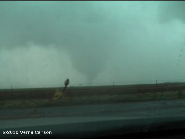
I spotted this brief tornado at E-470 and Pena Blvd at 1:30pm MDT. This lowering was heading towards the main concourse with thousands of people inside. Storm was tornado warned after this. Sirens sounded inside. United Airlines canceled 40 flights due to this one supercell. After touchdown debris was seen floating in the air. Some plastic bags and tin was raining down in the field west of E-470! Luckily it did not materialize into a strong tornado - it's path would have taken it right across the DIA main terminal. Large hail to 3" was also reported in Commerce City, CO to the north causing significant auto and home damage to many neighborhoods.


2010 Tornadoes: 13
Lifetime Tornadoes: 133

Saturday, May 22, 2010

Tornado after Tornado in central Oklahoma! May 19, 2010

Wednesday, May 19, 2010

2010-05-19 Report

High Risk of severe issued by the SPC
30% Hatched Tornado threat. Strong long-track tornadoes expected.

Tornado #3 the largest of the day west of Hennessey, OK
Tornado #3 Ropes out.
Tornado #5 is partially wrapped in rain and coming right towards me. From the viewfinder I can see it better so I watch it there as it moves my way.
Tornado #6 forms close to the west side of I-35 and moves towards Stillwater, OK
Map of the tornado locations and our path in yellow


What an amazing chase day! Started in Amarillo with Randy Denzer and Bill Tabor and shot east on I-40 to around the Clinton area. SPC went high risk to the area north of us and soon a cell fired back to the west near Roger Mills county. Not wanting to be on the south side of the river in central OK we shot up north to Watonga, OK where a storm went from a small tower to having ground features in only 20 minutes! After that the chase was on. We followed it east through Hennessey and all the way to Stillwater, OK. 6 Tornadoes and a record streaming viewer number I was completely satisfied. One of the top two or three chases I'd say!

2010 Tornadoes: 12
Lifetime Tornadoes: 132

Tuesday, May 18, 2010

2010-05-18 Moderate Risk Today!


Moderate risk today for large hail and tornadoes. Will be on the road asap. The models are showing two possible areas for supercell development. One near Lamar, CO and one in the northern TX panhandle. Depending on when I can get going I'll make the most southern target possible. Tonight is an overnight in AMA and then an even bigger day on Wednesday! Hoping for an intercept like I had in Wakita, OK on May 10th!

Monday, May 10, 2010

2010-05-10 Report

Supercell forms near Woodward, OK and begins to show rapid rotation and a wall cloud just east of Cherokee, OK. Very near Wakita, OK from the movie TWISTER.
After a brief touchdown in the trees south of hw11 the tornado really gathers itself together right in front of me. Time is 20:41z or 3:41 CDT
Four dancing vortices form and snake around each other as the rip trees out of the ground and throw them into the powerlines. Roof sections of at least one house were hit.
The writhing serpentine tornado is on all sides of me now with incredible inflow winds. Large 12 foot diameter watering tanks are being lifted out of the fields on the right of me and rolling across the fields to the left!
Another 'finger' pops down out in front of me in the field, tears up the dirt and then disappears! The storm moves quickly northeast at 40 - 50 mph and becomes a large rain wrapped wedge as it heads towards Wakita, OK.


This puts me on the board for 2010 in a big way!
2010 Tornadoes: 6
Lifetime Tornadoes: 126

2010-05-10 High Risk Today!


All parameters are in place for a significant tornado outbreak today in se KS and e OK! You don't see a high risk like this in chaseable terrain more than a few times a year and on one of my favorite dates - May 10th! I am leaving Russell, KS here in a couple hours and plan to take the route straight south to Pratt giving myself the options of going after anything that spins up closer to the low center early. Both WRF 4k 'cheat sheet' models as Michael calls them are showing the storm of the day firing just south of Wichita at 23 - 0z and racing east. Interesting that neither show much in OK at all. This is what the models have been showing most all week so not surprising that the day of the event it looks like sc KS/nc OK will be the initiation point. Storm speeds are forecasat to be 50kts so everyone stay safe out there.

Friday, May 07, 2010

One of the best chase days in years!

While model differences are ongoing between the NAM and GFS it is clear that on monday sufficient instability, shear and forcing will be in place for a severe weather event. If it verifies with the current Capes >3500 and EHI(0-3km)>+12 it may be one of the best tornado days we have seen since the May 22-23 2008 event or possibly even the May 4-5, 2007 Greensburg tornado outbreaks. Regardless of where the surface features end up I will be heading out the day before for an overnight at most likely AMA and chasing Monday!

The Carlsons', Verne, Michael and Eric

The Carlsons', Verne, Michael and Eric

Contact Me for Helicopter Shots!

Flying Monkeys

My Blog List

Blog Archive