Live Geo-referenced Storm Chaser Video. First in the Field Aerial Live Streaming and Aerial Storm Intercepts. High Resolution Level II Radar Data. Severe Weather Forecasts and Reports by Storm Chasers/Severe Weather Videographers Verne, Michael and Eric Carlson. For live stream and video licensing contact us at: vernecarlson@hotmail.com

KRDO ColoSprgs Storm Chasers!

KRDO

KAKE Wichita Storm Chase Team!

KAKE

Denver's Channel 7 Storm Chasers

KMGH 7 News

License this Live Stream Now!

Follow us LIVE on iMap Tracker! When you see a car we are live.


Friday, July 24, 2009

Funnel of Darkness

Navigating the precarious boundaries where sanity ends and weather begins; FUNNEL OF DARKNESS follows one adventure filmmaker and his team, chasing the American Dream...down Tornado Alley.

The IFC.com Original five-episode web series FUNNEL OF DARKNESS premieres on Dailymotion.com Monday, July 27.

Funnel Of Darkness is a comedy series that follows adventure filmmaker Keith Severe (Keith Cecere) and his team of storm chasers (Team Severe) as they tear through America's heartland in a race to capture the best up-close and personal tornado footage the world has ever seen. A modern day storm chasing A-Team, the men that compromise Team Severe are a rag tag lot of storm chasing misfits and rock and roll dreamers.


>> Go to the page here <<

EPISODE 1 - "Team Severe, Come Out and Play!"

The competition is afoot, the girls abound and Team Severe is ready to win. Unfortunately, road holes and an unruly farmer stand between them and glory.


EPISODE 2 - "Severe Weather"

An old nemesis shows her face as Team Severe gets some new storm chasing gear and samples the local flavor of Oklahoma. The perfect storm shot lays just over the horizon, but will the boys get there in time?


EPISODE 3 - "Small Town Freaker Outers"

The weather has gone flat and Team Severe is in desperate need of a Tornado. The only solution is to throw a “storm summoning party” to appease the gods. Hopefully, the gods aren’t easily offended.


EPISODE 4 - "Anarchy in the O.K."

Still desperate for tornadoes and even more desperate for cash Team Severe takes to the stage and rocks out at a local bar. Channeling his spiritual guide, the character Bodhi from the world re-known film “Point Break,” Keith calls upon his troops for one final push to try and win the “Funnel Baggin’ Rally.


EPISODE 5 - "A Shot in the Dark"

With time running out, Team Severe cuts through the night, chasing down the biggest storm of their lives. Will it be enough to win the Funnel Baggin’ Rally? That’s for one crazy cowboy to decide.

Tuesday, July 21, 2009

Pictures from last night's possible Tornado in west Denver!

Hail damaged vinyl sided house in Wheat Ridge, CO N39 46.69 W105 7.37

Audi that had a tree limb fall on it's back window. N39 46.04 W105 7.24

Garage front taken off by large tree. N39 46.04 W105 7.24

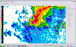
Reflectivity screen grab at 10:25pm MDT.

Velocity screen grab at 10:31pm MDT.

Vertically Integrated Liquid at 10:26pm MDT.

Tree limbs up to 4" diameter down along Ward Road. N39 47.96 W105 8.31

N39 47.96 W105 8.31

These 4 photos were between Kipling and Ward Rd on CR 58. N39 46.71 W105 7.46

News crews filming CR58 road blockage.

Large 40 foot high tree uprooted and across CR58.

Last night's storm tore through the west Denver suburb's with extreme force! I was shooting lightning shots from my deck but the line of storms that moved from Boulder to Castle Rock where so low to the ground that there were absolutely no CGs to capture.

At 10:45pm or so the west most cell went tornado warned so I hopped in the car and headed down to live stream the damage! Above you can see the deep hail drifts and large trees downed.

Friday, July 17, 2009

se CO supercell


Started out with Tony chasing the long-lived supercell from Burlington, CO down to south of Las Animas, CO. Along the way saw numerous cycles of the meso where it tried to produce a tornado. At times the wall cloud was churning on the ground with incredible RFD surges that snapped at least one powerpole mid-height! Encountered baseball hail by Lamar, CO that put a bunch of new nasty dents in my car before 3 of us pulled under a grove of trees and let the car-nage pass! The screen grab below was just one of the cycles that seeme as if something large was on the ground back in under there!

This day started out with only a slight risk to the south and no tornado probs. At the 10:30am SPC update - wow! 5% tornado and 30% hatched hail. Two tornado watches were issued and I took a half day of work off to chase it. Powerline snapped from straight line winds. Never did confirm a tornado on the lifecycle. Still tornado warned at this time. Ran out of roads to chase it!

Southeast CO supercell

Viewed from Las Animas. What a beast of a storm. Baseball hail. Tornado warned and wallclouds on the ground for county after county!

Burlington co storm!

Wednesday, July 15, 2009

Last Chance, CO

LP supercell dropped quarter size hail earlier.

Friday, July 10, 2009

Tornadoes possible in ne CO/se WY today!


Waking up this morning to what looks like another 3 days of slight risks on the high plains with today possibly being the highlight! I will definately be out this afternoon and live streaming the event on iMapTracker.

11am update: upper 60 Tds on the edge of CO with mid 60Tds into e CO. Cap looks breakable around Cheyenne, WY according to RUC. Convective temps of 80 F needed, already at mid 70s here. RUC breaks out precip around Cheyenne, WY at 21z.

SPC:
...CENTRAL HIGH PLAINS INTO THE CENTRAL PLAINS...
INCREASING UPSLOPE FLOW AND DESTABILIZATION SHOULD INCREASE STRONG
TO SEVERE THUNDERSTORMS ALONG THE FRONT RANGE OF THE CENTRAL ROCKIES
AND ADJACENT HIGH PLAINS DURING THE MID TO LATE AFTERNOON. DEEP
LAYER SHEAR WILL BE QUITE STRONG AND LIKELY SUPPORT A FEW SUPERCELLS
THROUGH THE EVENING...INCLUDING THE POTENTIAL FOR A TORNADO OR TWO.
HOWEVER...LARGE HAIL AND DAMAGING WINDS WILL BE PRIMARY THREATS WITH
THE MORE ORGANIZED STORMS. ACTIVITY COULD BUILD UPSCALE INTO A MCS
OR NEW DEVELOPMENT MAY OCCUR EWD INTO THE CENTRAL PLAINS OVERNIGHT
WITH ADDITIONAL RISK OR LARGE HAIL/DAMAGING WINDS.


Also this is pretty darn cool - on March 7, 2009 I nabbed the first ever georeferenced live stream of a tornado for WDT on our iMapTracker - FULL STORY HERE!


Sunday, July 05, 2009

Best Tornadoes of 2009!

April 26, 2009 Crawford, OK


April 26, 2009 Roll, OK


April 29, 2009 Garden City, KS


June 5, 2009 LaGrange, WY

June 11, 2009 Ordway, CO


June 15, 2009 Elbert, CO


2009 Tornadoes: 17
Lifetime Tornadoes: 116

Contact me for licensing at: vernecarlson@hotmail.com


The Carlsons', Verne, Michael and Eric

The Carlsons', Verne, Michael and Eric

Contact Me for Helicopter Shots!

Flying Monkeys

My Blog List

Blog Archive