
Plains forecast update 4, for March 31
1 week ago


 Chased the initial cells that formed south of Castle Rock and moved southeastward to Yoder, CO. All the while wanting to go east to the storm developing near Burlington.
 Finally left the dying storms near Colo Spgs and blasted east to intercept the southward moving bomb east of Kit Carson, CO where I ran into Dann Cianca and Travis Speakman as we watched the south moving storm collide with the line coming southeast. This merger created an intense forward flank wallcloud with rapid rotation and many brief but intense gustnado touchdowns. This one at 7:37pm MDT 10 mi south of Eads, CO - lasted less than a minute. Cored the storm after this in search of some of the possible baseball hail but only got heavy rain at that point.
 On the way home got treated to a spectacular Mammatus display. This cellphone pic only shows a small section of the panorama. Not bad for a mid July chase.
 Chased the big HP bomb storm from north of Cheyenne, WY into Nebraska. North of Kimbal the RFD dust and precip cleared long enough to get a view into the core. Still not sure if this was rotating that strongly or not..


 Caught the storm of the day as it rapidly developed over Boulder, CO and started it's march to the northeast. It stayed frustratingly high based all the way out to Ft. Morgan where a new cell to the northeast began getting stronger. I core punched my way up to get ahead of this new cell and for awhile I was between both cells but could never get out ahead of the fast moving system. Just east of Yuma, CO I core punched in the RHINO and got pelted by golfballs and then baseballs. The hail was letting up but I wanted more so I went back to where they had fallen and documented the size as easily 3" and this was after a full 10 minutes of melting. The actual stones may have been closer to softball at 3 1/2" when they fell. No damage to the Rhino although I do have one new window crack on the front windshield. (Front window is stock and unmodified for video quality).

 Tornado #1 northeast of Deertrail, CO 01:14z (7:14pm MDT)
 Tornado #2 northeast of Deertrail, CO 02:30z (8:30pm MDT)
 If you were watching my live stream you got to see it all! http://www.tornadovideos.net/live


 Started the day east of Cheyenne, WY when cells fired to the north near Yoder, WY. Got on the storm coming down the North Platte river in WY at Torrington and followed it to Scottsbluff, NE. The first cell in the line moved northeast of hw 26. The second cell in the line moved into Scottsbluff, NE where it produced a brief but intense set of multi-vortex tornadoes all around me on the east side of town! As I was leaving the town to the east the power went off - very erie. The intense suction vortices were ripping up street signs and billboards and throwing them into the powerlines just feet away from me. Two or three vortices spun up to my north with one of them coming back towards me to the west. Then there was a white cone that dropped behind me to the south only yards away. (not captured on video) Then a fifth vortex through debris into the powerlines to my right causing the spark seen in the picture above. My closest and most exciting tornado encounter to date!

 High Risk of severe issued by the SPC
 30% Hatched Tornado threat. Strong long-track tornadoes expected.
 Tornado #3 Ropes out.
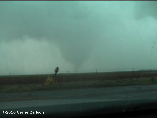 Tornado #5 is partially wrapped in rain and coming right towards me. From the viewfinder I can see it better so I watch it there as it moves my way.
 Tornado #6 forms close to the west side of I-35 and moves towards Stillwater, OK
 Map of the tornado locations and our path in yellow


 Moderate risk today for large hail and tornadoes. Will be on the road asap. The models are showing two possible areas for supercell development. One near Lamar, CO and one in the northern TX panhandle. Depending on when I can get going I'll make the most southern target possible. Tonight is an overnight in AMA and then an even bigger day on Wednesday! Hoping for an intercept like I had in Wakita, OK on May 10th!
 Supercell forms near Woodward, OK and begins to show rapid rotation and a wall cloud just east of Cherokee, OK. Very near Wakita, OK from the movie TWISTER.
 After a brief touchdown in the trees south of hw11 the tornado really gathers itself together right in front of me. Time is 20:41z or 3:41 CDT
 Four dancing vortices form and snake around each other as the rip trees out of the ground and throw them into the powerlines. Roof sections of at least one house were hit.
 The writhing serpentine tornado is on all sides of me now with incredible inflow winds. Large 12 foot diameter watering tanks are being lifted out of the fields on the right of me and rolling across the fields to the left!
 Another 'finger' pops down out in front of me in the field, tears up the dirt and then disappears! The storm moves quickly northeast at 40 - 50 mph and becomes a large rain wrapped wedge as it heads towards Wakita, OK.


 All parameters are in place for a significant tornado outbreak today in se KS and e OK! You don't see a high risk like this in chaseable terrain more than a few times a year and on one of my favorite dates - May 10th! I am leaving Russell, KS here in a couple hours and plan to take the route straight south to Pratt giving myself the options of going after anything that spins up closer to the low center early. Both WRF 4k 'cheat sheet' models as Michael calls them are showing the storm of the day firing just south of Wichita at 23 - 0z and racing east. Interesting that neither show much in OK at all. This is what the models have been showing most all week so not surprising that the day of the event it looks like sc KS/nc OK will be the initiation point. Storm speeds are forecasat to be 50kts so everyone stay safe out there.
 While model differences are ongoing between the NAM and GFS it is clear that on monday sufficient instability, shear and forcing will be in place for a severe weather event. If it verifies with the current Capes >3500 and EHI(0-3km)>+12 it may be one of the best tornado days we have seen since the May 22-23 2008 event or possibly even the May 4-5, 2007 Greensburg tornado outbreaks. Regardless of where the surface features end up I will be heading out the day before for an overnight at most likely AMA and chasing Monday!


 Chased the Washington and Belleville, KS tornado warned storms. No tornadoes verified from my view but deep convection, low hanging scud, crazy inflow winds and wild lightning after dark. Today the threat moves into the AR to IL area.


 Just a quick report for yesterday as I have to pour over models and pick a target for today. I shot down through the 'Northwest Passage' (Limon, Lamar, Amarillo) late yesterday afternoon and toyed with the idea of hanging back on the cells in northeast NM but with the tornado watch and Amarillo in my sites I kept punching south. Ended up chasing the cell that was almost stationary in Oldham county northwest of Vega, TX. It had good structure and a ragged wall cloud with fingers under it. No actual tornado reports as seen from my location or other chasers. Did my first live phoner with the Weather Channel. Thanks to Kendra Reed for setting that up! Today it's either the caprock or western Kansas. Tomorrow looks great along the warm front/triple point in se NE!
 Weds April 21, 2010: Looking at the GFS we have a nice 500h trough coming in on Weds afternoon and just starting to overspread the warm sector in eastern CO. Based on where the surface features line up I plan on positioning myself somewhere from Limon, CO to Lamar, CO with an overnight trip down to Amarillo to be in position for the real show on Thursday!
 Thurs April 22, 2010: I am liking the Liberal, KS to western OK area for the best juxtoposition of 500h divergent winds and dryline Cape.

 This day the SPC had a slight risk from Canada down to the OK panhandle crossing the far eastern plains of Colorado. The dynamics for severe weather were certainly in place and had the dewpoints been higher in the upper 50 range vs the upper 40s that we actually had - this day might have been a big tornado day.
