Edit: Gotta agree with Chris that high LCLs and a persistant cirrus shield will make this one to pass on. No chasing today.
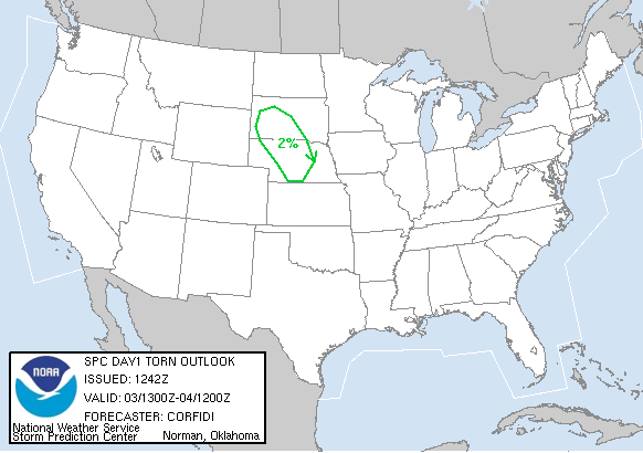
...CNTRL/NRN PLNS... SRN PART OF SHORTWAVE TROUGH NOW IN MT WILL REDEVELOP E/SE INTO WRN SD AND NEB LATER TODAY/TONIGHT. ASSOCIATED FORCING FOR ASCENT AND STRONG SURFACE HEATING SHOULD SUPPORT STORM DEVELOPMENT ALONG COLD FRONT IN THE WRN DAKOTAS BY LATE AFTERNOON. MODEST DEEP WLY SHEAR IN ND SHOULD GRADE INTO SOMEWHAT STRONGER /30-35 KT/ WNWLY SHEAR IN SD AND NEB...WHERE PROFILES WILL EXHIBIT SUBSTANTIAL VEERING WITH HEIGHT. COUPLED WITH STEEP MID LEVEL LAPSE RATES AND AVERAGE BOUNDARY LAYER DEWPOINTS IN THE LOW 50S...SETUP COULD YIELD A FEW SUSTAINED UPDRAFTS/POSSIBLE SUPERCELLS WITH HIGH WIND/HAIL AND PERHAPS AN ISOLATED TORNADO.
From the North Platte, NE HWO: AN ACTIVE SEVERE WEATHER DAY IS EXPECTED LATE THIS AFTERNOON AND THIS EVENING.LARGE HAIL AND WIND DAMAGE WILL BE THE PRIMARY THREAT. ISOLATED TORNADOES ARE ALSO A POSSIBILITY. SCATTERED SEVERE THUNDERSTORMS ARE EXPECTED TO DEVELOP LATE THIS AFTERNOON ALONG OR NEAR HIGHWAY 20 ACROSS CHERRY AND SHERIDAN COUNTIES. STORM MOTION WILL TO THE EAST AND SOUTHEAST AT NEAR 20MPH. WINDS ALOFT WILL BE STRONG SUPPORTING LONG LIVED STORMS CAPABLE OF LARGE HAIL AND WIND DAMAGE. AN ISOLATED TORNADO IS POSSIBLE...MOST LIKELY OCCURRING BEFORE NIGHTFALL.
Live Geo-referenced Storm Chaser Video. First in the Field Aerial Live Streaming and Aerial Storm Intercepts. High Resolution Level II Radar Data. Severe Weather Forecasts and Reports by Storm Chasers/Severe Weather Videographers Verne, Michael and Eric Carlson. For live stream and video licensing contact us at: vernecarlson@hotmail.com
License this Live Stream Now!
Follow us LIVE on iMap Tracker! When you see a car we are live.
Saturday, June 03, 2006
Subscribe to:
Post Comments (Atom)
The Carlsons', Verne, Michael and Eric
My Blog List
-
-
-
Frasi Di Auguri Di Fine Anno Auguri3 years ago
-
-
-
-
-
-
Odd Season8 years ago
-
Dodge City Monster9 years ago
-
Blog Has Moved10 years ago
-
-
-
Full-Up11 years ago
-
sky drama11 years ago
-
-
Hurricane Sandy11 years ago
-
A Moment in Time....11 years ago
-
-
Replacing the Free Site with Free Trials12 years ago
-
A few thoughts12 years ago
-
New York Mammatus12 years ago
-
test image13 years ago
-
-
NEW BLOG -- Update Link14 years ago
-
NEW BLOG14 years ago
-
Sams Storm Blog has moved!15 years ago
-
A World of Hurt15 years ago
-
March 28th Tornado Chase17 years ago
-
-
-
-
-
-
-
-
-
-
-
-
-
-
-
-
-
-
-
-
-
-
-
-
Links
Contributors
Blog Archive
-
▼
2006
(417)
-
▼
June
(26)
- Storm tracks south over Boulder and Denver
- Possible tornado near Hugo, CO at 3:21pm?
- Chasing today in eastern CO
- Lightning over Denver
- Multimedia message
- Twin Suparu's!
- The top chases of 2006
- Possible Severe in E CO Thursday
- Chased all the way up to the Pawnee Grasslands
- Severe weather possible close to Denver
- Last day of chasing for Chasecation 2006
- Multimedia message
- Potentially big day today in the NE panhandle!
- More pics from the amazing Meso in Cherry County, NE
- Meso in Cherry County, NE!
- Multimedia message
- Now the wait begins
- We are in Norfolk, NE
- Multimedia message
- Iowa chase on Friday?
- Can't chase today
- Chase season winding down
- Chase potential today in central NE!
- Eastern CO Meso pics!
-
▼
June
(26)
1 comment:
I really enjoyed looking at your site, I found it very helpful indeed, keep up the good work.
»
Post a Comment