
Models are showing storms firing over the Palmer Divide and heading east from 5:00pm to 10:00pm at night. Michael and I will be going out and chasing supercells. We should atleast get some good lightning shots!

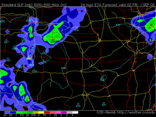
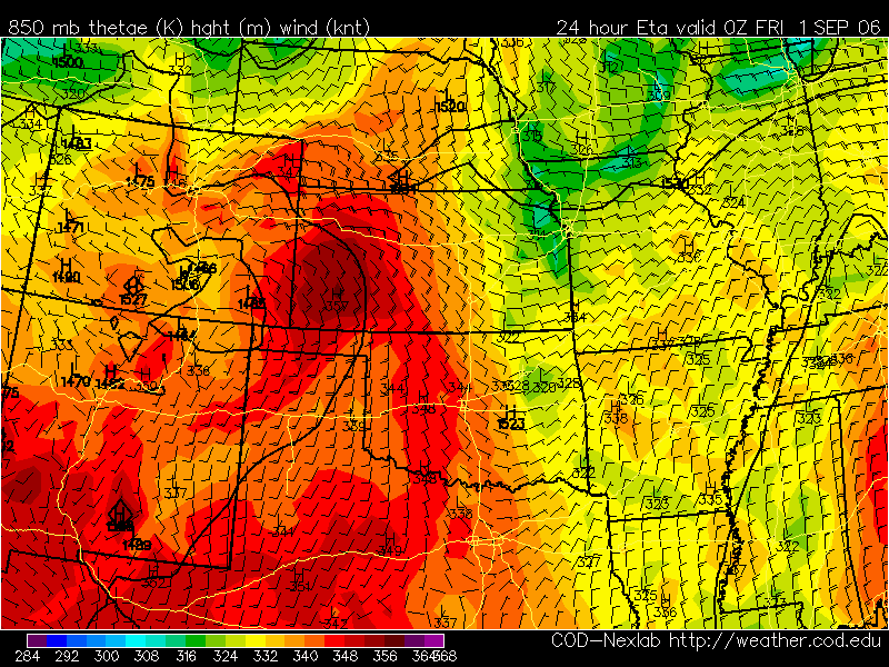
...CNTRL HIGH PLAINS... WHILE STRONG MOISTURE RETURN DOES NOT APPEAR LIKELY ACROSS THE REGION...MODEST BOUNDARY LAYER MOISTENING WILL OCCUR NEAR LEE-TROUGH AND ADVANCING COLD FRONT FROM SWRN NEB SWD ALONG CO/KS BORDER. SURFACE DEWPOINTS AROUND 60F AND TEMPERATURES CLIMBING THROUGH THE 80S WILL CONTRIBUTE TO MODERATE DESTABILIZATION WITH LAPSE RATES STEEPENING WITH DAYTIME HEATING. MEAN LAYER CAPE ON THE ORDER OF 1500 J/KG IS ANTICIPATED BY AFTERNOON...WHEN FORCING NEAR INTERSECTION OF COLD FRONT AND SURFACE TROUGH/WEAK DRY LINE SHOULD LOCALLY ELIMINATE CAPPING ASSOCIATED WITH ELEVATED MIXED LAYER. WEAK BUT VEERING WINDS WITH HEIGHT FROM LOWER TO MID-LEVELS...BENEATH MODERATE WESTERLY HIGH LEVEL FLOW...SHOULD PROVE ADEQUATE FOR ISOLATED SUPERCELLS WITH HAIL AND HIGH WINDS. ADDITIONAL ACTIVITY WITH SEVERE HAIL POTENTIAL MAY ALSO OCCUR IN RELATIVELY MOIST POST-FRONTAL UPSLOPE FLOW REGIME FROM NEB PNHDL TO THE CO FRONT RANGE.


 Models are showing storms firing over the Palmer Divide and heading east from 5:00pm to 10:00pm at night. Michael and I will be going out and chasing supercells. We should atleast get some good lightning shots!
 ...CNTRL HIGH PLAINS... WHILE STRONG MOISTURE RETURN DOES NOT APPEAR LIKELY ACROSS THE REGION...MODEST BOUNDARY LAYER MOISTENING WILL OCCUR NEAR LEE-TROUGH AND ADVANCING COLD FRONT FROM SWRN NEB SWD ALONG CO/KS BORDER. SURFACE DEWPOINTS AROUND 60F AND TEMPERATURES CLIMBING THROUGH THE 80S WILL CONTRIBUTE TO MODERATE DESTABILIZATION WITH LAPSE RATES STEEPENING WITH DAYTIME HEATING. MEAN LAYER CAPE ON THE ORDER OF 1500 J/KG IS ANTICIPATED BY AFTERNOON...WHEN FORCING NEAR INTERSECTION OF COLD FRONT AND SURFACE TROUGH/WEAK DRY LINE SHOULD LOCALLY ELIMINATE CAPPING ASSOCIATED WITH ELEVATED MIXED LAYER. WEAK BUT VEERING WINDS WITH HEIGHT FROM LOWER TO MID-LEVELS...BENEATH MODERATE WESTERLY HIGH LEVEL FLOW...SHOULD PROVE ADEQUATE FOR ISOLATED SUPERCELLS WITH HAIL AND HIGH WINDS. ADDITIONAL ACTIVITY WITH SEVERE HAIL POTENTIAL MAY ALSO OCCUR IN RELATIVELY MOIST POST-FRONTAL UPSLOPE FLOW REGIME FROM NEB PNHDL TO THE CO FRONT RANGE.


No comments:
Post a Comment