Live Geo-referenced Storm Chaser Video. First in the Field Aerial Live Streaming and Aerial Storm Intercepts. High Resolution Level II Radar Data. Severe Weather Forecasts and Reports by Storm Chasers/Severe Weather Videographers Verne, Michael and Eric Carlson. For live stream and video licensing contact us at: vernecarlson@hotmail.com
License this Live Stream Now!
Follow us LIVE on iMap Tracker! When you see a car we are live.

Friday, June 27, 2008
2008-05-24 TWISTEX Plane test flight
Wednesday, June 25, 2008
Friday, June 20, 2008
Tornado warned supercell
Tuesday, June 17, 2008
Steve Ziegler of Collyer, KS finds the WW3
 Steve Ziegler found the WW3 six miles south of Collyer, KS on June 12, 2008 exactly three weeks after it was launched into the large cone tornado on May 22, 2008.
 The WW3 has it's nose broken off, the hatch cover is missing exposing the battery pack.
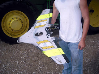 The camera, which would be the prize to find has been dislodged from the bottom. If this can be found it may contain some very compelling video of the flight!
Sunday, June 15, 2008
Severe potential along the front range
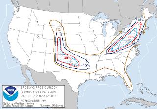 SPC has the monday and tuesday highlighted for severe weather up and along the front range of CO. A sagging cold front and northwest flow aloft means large hail and high winds are the main threats - however an isolated tornado or two cannot be ruled out.
...SRN/CENTRAL ROCKIES... DESPITE LOW DEWPOINTS AT THIS TIME...FRONT MOVING SWD ALONG ERN SLOPES WILL ADVECT AT LEAST 55 TO 60F DEWPOINTS WWD TO EDGE OF THE HIGHER TERRAIN. THESE DEWPOINTS COMBINED WITH DIURNAL HEATING WILL RESULT IN MODERATE INSTABILITY...WITH THE MOIST UPSLOPE FLOW AIDING THUNDERSTORM INITIATION. STRONGLY VEERING WINDS WITH HEIGHT WILL BE FAVORABLE FOR SUPERCELLS. THOUGH AN ISOLATED TORNADO OR TWO IS POSSIBLE...WEAK WINDS IN THE LOWER 1-2 KM SUGGEST THAT LARGE HAIL AND WIND DAMAGE WOULD BE THE PRIMARY THREATS.
Friday, June 13, 2008
Wicked Witch Found!
 On May 22, 2008 I lost a Wicked Witch RC Video Plane into the large cone tornado south of Collyer, KS. This plane has been found!
I had been having trouble locking in the wireless video signal so with the tornado approaching from the west I quickly mounted an ActionCam flash memory camera on the plane and flew it out towards the tornado. The plane got into the inflow and I lost sight of it under the dark rainfree base. I called to the group to help me spot it in the air. We saw it a couple of times but then it dissapeared under the RFB in front of the tornado. Whether it actually went into the tornado - only the video onboard will tell.
Well this morning on my voicemail was a message from a Steve Ziegler in Kansas. My plane had been found! It was lying in a field 6 miles south of Collyer, KS - roughly where I lost it. It had been sitting there for three weeks and they found it while planting corn.
I quickly called him back and asked him to describe how it looked and was there a large black cigar shaped camera on the bottom?? NO CAMERA... the nose had been broken off but no camera.
Today they are going to go back out to the area to look for the camera now that they know what it looks like. If the camera can be found it should have the video still preserved on the memory card inside. I anxiously await thier call!
Update: I have since talked to Steve's mom Angie and they are doing a story on finding the plane for their local paper. They will be sending the plane back to me and the location of the camera still is unknown. It was likely separated from the plane when it first went down or in the three weeks of blowing around in the field.
Thursday, June 12, 2008
2008-06-11 Report
Storms rapidly form south of Hays, KS. We shoot south and catch this Tornado warned storm southwest of Concordia, KS. No tornadoes formed so we leave this storm and head for the tail end storms now near Great Bend, KS.
We get to the tail end storm and it is a BEAST! This thing had the most amazing structure ever!
It tried many times to tornado right next to us, the motion was amazing. This storm went on to hit Salina, KS and Manhatan, KS where sadly two lives where lost.
Wednesday, June 11, 2008
Hoping for a Kansas surprise!
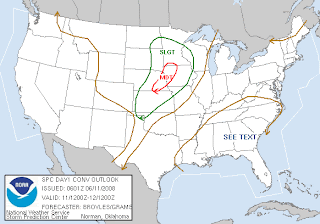
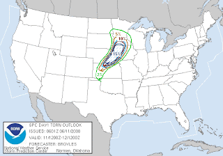 Eric and I will be heading out this morning from Denver as soon as possible and we are targeting the NE/KS border on the south end of the 15% hatched area above. Analyzing the NAM last night I like this area logistically because we can reach it by 2pm CDT and also because of the surface low and dryline bulge in the Hays, KS area. We won't be with TWISTEX on this trip since I only have the one day off. We are out the door very soon here!
FORECAST SOUNDINGS ACROSS THE NRN AND WRN PART OF THE WARM SECTOR SHOW STRONG VERTICAL SHEAR PROFILES ASSOCIATED WITH THE MID-LEVEL JET. THIS ALONG WITH GRADUAL VEERING IN THE LOW TO MID-LEVELS SHOULD BE VERY FAVORABLE FOR SUPERCELLS. DISCRETE SUPERCELLS WILL BE MOST LIKELY DURING THE LATE AFTERNOON AND EARLY EVENING BEFORE A SQUALL-LINE ORGANIZES. THE BOUNDARY LAYER SHEAR ASSOCIATED WITH THE STRENGTHENING LOW-LEVEL JET WILL BE FAVORABLE FOR TORNADOES WITH THE MORE PERSISTENT SUPERCELLS. FORECAST SOUNDINGS ACROSS THE MODERATE RISK AREA INCREASE 0-1 KM STORM RELATIVE HELICITIES INTO THE 250 T0 300 M2/S2 RANGE SUGGESTING STRONG TORNADOES WILL BE POSSIBLE WITH THE MORE DOMINANT SUPERCELLS. A TRANSITION TO A MORE LINEAR MODE SHOULD OCCUR DURING THE EVENING AS A SQUALL-LINE WITH WIDESPREAD WIND DAMAGE ORGANIZES AND MOVES EWD ACROSS THE MODERATE RISK AREA. HOWEVER...VERTICAL SHEAR SHOULD STILL SUPPORT SUPERCELLS EMBEDDED IN THE LINE AND AHEAD OF THE LINE. THE SEVERE THREAT SHOULD PERSIST DURING MUCH OF THE OVERNIGHT PERIOD DUE TO THE RELATIVELY LARGE WARM SECTOR. FURTHER SOUTHWEST ACROSS WRN AND CNTRL KS...FORECAST SOUNDINGS SHOW STRONG VERTICAL SHEAR SUGGESTING SUPERCELLS WILL ALSO DEVELOP IN THIS REGION. A PLUME OF STEEP MID-LEVEL LAPSE RATES IS FORECAST FROM THE TX PANHANDLE NEWD ACROSS CNTRL KS. THIS SHOULD SUPPORT A THREAT FOR VERY LARGE HAIL. IN ADDITION...AN ISOLATED STRONG TORNADO MAY OCCUR ACROSS NRN KS WHERE LCL HEIGHTS WILL BE LOWER THAN AREAS FURTHER SOUTH. EVENTUALLY...A LINEAR MCS SHOULD ORGANIZE AND MOVE SEWD ACROSS CNTRL KS DURING THE EVENING. FURTHER SOUTHWEST ACROSS SW KS AND THE TX PANHANDLE...THUNDERSTORM DEVELOPMENT SHOULD REMAIN ISOLATED. STILL...STEEP MID-LEVEL LAPSE RATES AND STRONG VERTICAL SHEAR MAY BE SUFFICIENT FOR AN ISOLATED THREAT FOR VERY LARGE HAIL IN THIS REGION.
Monday, June 09, 2008
New AP camera
Tornadoes!
Since we've been partnering with Tim Samaras and the NG crew I haven't been able to post any video from the past couple of chases, but I've been collecting screen grabs from the tapes for your enjoyment. Here's a couple of 'em:
 A rotating meso with a developing tornado underneath crosses the highway just yards infront of us.
 Michael photographs the needle tornado.
 A nice tube on the ground...
 ...But from where? This little spinup was associated with the detached cloud above.
Saturday, June 07, 2008
Central Nebraska
A few down days for us as we opt out of the sagging cold front setups and wait for the next big trough to come in next week possibly Tues or Weds.
Thursday, June 05, 2008
High risk thursday - again!
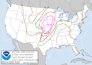
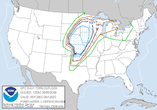 Yesterday we lingered too long in Kansas and missed the tornado action to the north in NE and e CO but the tornadoes where out in Iowa - a target that few realised. But today marks the third thursday in a row that we've had a High Risk of severe weather - and we've gotten tornadoes each of these days.
Looking at the RUC and WRF models I think the triple point sets up back south and west a bit south of Lincoln to the KS/NE line. The warm front where storms will go crazy as they cross it will arc northeasterly from there to the Sioux City, IA area. We are all meeting in 1/2 hour to discuss today's target which will likely be Sioux City, IA.
Live streaming and tracker will be running and the witches will be flying!
INTENSITY OF WIND FIELD THROUGHOUT THE PLNS ENSURES THAT ANY SUSTAINED UPDRAFTS WILL ROTATE. BUT DECIDEDLY MERIDIONAL/LARGELY UNIDIRECTIONAL NATURE OF THE PROFILES ABOVE THE NEAR-SFC LAYER /REFLECTING EARLY-SPRING TYPE KINEMATIC SETUP/ LIKELY WILL YIELD VERY STRONGLY ELONGATED AND SHEARED STORMS. NEVERTHELESS...GIVEN QUALITY OF MOISTURE INFLOW AND MERIDIONAL EXTENT OF WARM SECTOR...THESE COULD YIELD STRONG...LONG TRACK TORNADOES.
Wednesday, June 04, 2008
Gettting ready in Salina, KS
Stay safe everyone out there!
Tornadoes and large Hail Expected Today in KS
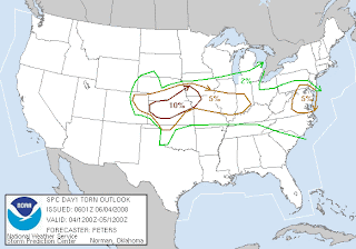 Large hail and tornadoes are expected today as a very unstable airmass with 70s dewpoints develops across KS ahead of an amplifying upper level trough. Our team is in Salina, KS this morning for the first of what will be two days of significant severe weather. This trip we will be focusing on getting overall storm structure video and attempting to fly a Wicked Witch 3 into a tornado!
Sunday, June 01, 2008
Isolated tornadoes possible in northeast CO today
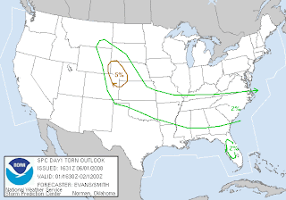 Dewpoints are already up to 55 in Burlington, CO and in the low 50s up to the front range. Both SPC and Boulder WFO are mentioning tornadoes. SPC has singled out ne CO/w NE as a bullseye.
Edit: I opted not to chase today as it was clear the cirrus shield over CO kept temps down and no noteworthy storms developed. There was a tornado watch in e WY/w NE and one long lived supercell in the NE panhandle but only one funnel was reported.
...CENTRAL HIGH PLAINS... SURFACE LOW WILL BECOME BETTER DEFINED NEAR THE CO FRONT RANGE/SERN WY THIS AFTERNOON WITH SELY LOW LEVEL WINDS INCREASING LATE IN THE DAY/EVENING OVER THE HIGH PLAINS. SHORTWAVE TROUGH IS FORECAST TO CREST BUILDING RIDGE AND INCREASE CONVECTION OVER PORTIONS OF WY/CO MOUNTAINS THIS AFTERNOON. AS THIS ACTIVITY INTERACTS WITH 50+F SURFACE DEW POINTS AND MARGINAL INSTABILITY JUST EAST OF THE HIGHER TERRAIN...STORMS SHOULD INCREASE WITH STRONG DEEP LAYER SHEAR. SUPERCELLS CAPABLE OF LARGE HAIL WILL BE PRIMARY SEVERE THREAT...WITH ISOLATED TORNADO THREAT LIKELY INCREASING WHERE STRONGER SELY H85 FLOW DEVELOPS NEAR FAR NERN CO/WRN NEB. ACTIVITY SHOULD INCREASE/ORGANIZE INTO A CLUSTER/MCS INTO WRN NE/NERN CO/NWRN KS THIS EVENING WITH ISOLATED SEVERE THREAT SPREADING GENERALLY ESEWD OVERNIGHT.
The Carlsons', Verne, Michael and Eric

My Blog List
-
-
-
Frasi Di Auguri Di Fine Anno Auguri3 years ago
-
-
-
-
-
-
Odd Season8 years ago
-
Dodge City Monster9 years ago
-
Blog Has Moved10 years ago
-
-
-
Full-Up11 years ago
-
sky drama11 years ago
-
-
Hurricane Sandy11 years ago
-
A Moment in Time....11 years ago
-
-
Replacing the Free Site with Free Trials12 years ago
-
A few thoughts12 years ago
-
New York Mammatus12 years ago
-
test image13 years ago
-
-
NEW BLOG -- Update Link14 years ago
-
NEW BLOG14 years ago
-
Sams Storm Blog has moved!15 years ago
-
A World of Hurt15 years ago
-
March 28th Tornado Chase17 years ago
-
-
-
-
-
-
-
-
-
-
-
-
-
-
-
-
-
-
-
-
-
-
-
-
Links
Contributors
Blog Archive
-
▼
2008
(172)
-
▼
June
(15)
- 2008-05-24 TWISTEX Plane test flight
- Lightning over Denver - first of the season!
- Tornado warned supercell
- Steve Ziegler of Collyer, KS finds the WW3
- Severe potential along the front range
- Wicked Witch Found!
- 2008-06-11 Report
- Hoping for a Kansas surprise!
- New AP camera
- Tornadoes!
- Central Nebraska
- High risk thursday - again!
- Gettting ready in Salina, KS
- Tornadoes and large Hail Expected Today in KS
- Isolated tornadoes possible in northeast CO today
-
▼
June
(15)


