Live Geo-referenced Storm Chaser Video. First in the Field Aerial Live Streaming and Aerial Storm Intercepts. High Resolution Level II Radar Data. Severe Weather Forecasts and Reports by Storm Chasers/Severe Weather Videographers Verne, Michael and Eric Carlson. For live stream and video licensing contact us at: vernecarlson@hotmail.com

KRDO ColoSprgs Storm Chasers!

KRDO

KAKE Wichita Storm Chase Team!

KAKE

Denver's Channel 7 Storm Chasers

KMGH 7 News

License this Live Stream Now!

Follow us LIVE on iMap Tracker! When you see a car we are live.


Monday, May 01, 2006

4600 J/kg SBCAPES for Tuesday


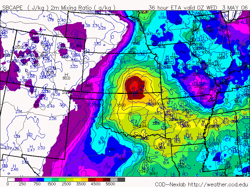
Capes for tomorrow in the Wichita, KS area are on the order of 4600 according to the ETA/NAM. It's been along time since I've seen capes this high. If the upper level winds were over KS instead of SD this would be a no brainer chase day. As it is I am going to wait until the 11:00pm MDT Day 1 outlook tonight to make a preliminary decision on whether or not to chase tomorrow.

1 comment:

Unknown said...

If you wanna chase tomorrow I haven't looked at models...but I'm game!!!!

The Carlsons', Verne, Michael and Eric

The Carlsons', Verne, Michael and Eric

Contact Me for Helicopter Shots!

Flying Monkeys

My Blog List

Blog Archive