Live Geo-referenced Storm Chaser Video. First in the Field Aerial Live Streaming and Aerial Storm Intercepts. High Resolution Level II Radar Data. Severe Weather Forecasts and Reports by Storm Chasers/Severe Weather Videographers Verne, Michael and Eric Carlson. For live stream and video licensing contact us at: vernecarlson@hotmail.com

KRDO ColoSprgs Storm Chasers!

KRDO

KAKE Wichita Storm Chase Team!

KAKE

Denver's Channel 7 Storm Chasers

KMGH 7 News

License this Live Stream Now!

Follow us LIVE on iMap Tracker! When you see a car we are live.


Monday, March 30, 2009

Stream Probe completed!


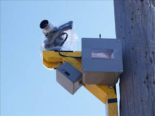
Adding to my arsenal of tornado projects I am pleased to announce the first of it's kind in the world tornado probe that I call the 'SCARECROW'. I developed this tornado probe because I think we can do better than the ankle high views and sampling from probes to date. I want to get up as high as possible and still be firmly attached to the ground. Power poles are typically 30 feet high and are anchored 6 feet into the ground. In a strong tornado the power pole and scarecrow may be significantly damaged but as long as I can find the parts I can recover the HD video SD card and repair/rebuild the probe. Even if this probe is completely lost I still live streamed the video over TVN iMapTracker and recorded it on my laptop in very good quality.
SCARECROW is a rapid deployable - insitu, ratchet strapped, tornado video probe and atmospheric data gatherer. It has been field tested twice in strong winds and perfoms well. It is completely controllable remotely from our vehicle at up to 1/2 mile away! It has the following features:

  • deployable on any power pole at up to 5m height.
  • 1080p HD video capture of up to 1 hour in duration on recoverable SD media
  • Live stream through viewfinder transmittion of up to 1/2 mile away at 1.2 Ghz (2 mile range at 900mhz pending)
  • Pan, Tilt, Zoom remote control
  • Compressed air remote controlled lens cleaning (under development, parts ordered)
  • Max pressure drop sensor and recorder (done)
  • Max airspeed sensor and recorder (done)

Possible chase on Saturday April 4


GFS and SPC are advertising a possible chase day this Saturday April 4th. Right now the GFS has things pretty far east on Sat evening but the GFS is known to 'slow' things down as the day approaches and make this more of a Wichita Falls, TX type of day. Also not liking the 'just-in-time' moisture return. Being a weekend makes it appealing. Have to keep an eye on this one.


Wednesday, March 25, 2009

Significant snowfall coming to Denver Thursday!

Winter storm warning in effect from 6 am Thursday to 6 am mdt friday, The NWS in denver has issued a winter storm warning for heavy snow and considerable blowing snow, which is in effect from 6 am Thursday to 6 am mdt Friday. The winter storm watch is no longer in effect. Snowfall will begin in and near the front range foothills early thursday morning where a few inches of snow accumulation may occur by mid-morning. Snowfall will then spread east across the northeast plains through the remainder of the morning following the passage of strong cold front. Look for moderate to heavy snowfall to develop along the front range including the greater denver metro area by midday. East winds 10 to 20 mph will become north to northeast 20 to 30 mph with gusts to around 40 mph after the passage of this front. The strong winds will likely produce areas of blowing and drifting snow during the afternoon and evening, with near whiteout conditions possible on the palmer divide south of denver. Total snow accumulations by later Thursday night will range from 8 to 15 inches in the i-25 urban corridor and across south park, and from 1 to 2 feet in the front range foothills and over the palmer divide. Remember, a winter storm warning means hazardous winter weather conditions are imminent or highly likely. Significant snow accumulations are occurring or expected. Strong winds are also expected. This will make travel very hazardous or impossible.

Tuesday, March 24, 2009

2009-03-23 Report

A fun chase that took us from Russell, KS down to the OK/KS border, east of I-35 for a bit and then down to Perry, OK.
Got a WW3 flight in mid afternoon. Winds were sustained 28mph with gusts to 35mph. Very difficult to fly but possible!
Funnel cloud near Medford OK, 21:09z
The Guthrie OK meso as it was about to core me on I-35, 00:09z

Monday, March 23, 2009

Cell north of Attica KS

first cell of the day letting it go for the next one

Waking up in Russell KS

Today we have howling winds out of the south here and a good shot at tornadoes!

Sunday, March 22, 2009

Upgrade to Moderate!


Live streaming today at: TVN
SPC just upgraded tomorrow to MODERATE RISK. This is in response to the better moisture return that will fuel the warm sector tomorrow. Strong tornadoes are possible in the moderate risk area!
THE MOST INTENSE STORMS COULD PRODUCE VERY LARGE HAIL FROM SE KS SSWWD ACROSS WCNTRL OK WITH ISOLATED LARGE HAIL ALSO POSSIBLE IN NORTH TX. IN ADDITION...FORECAST SOUNDINGS BY EARLY EVENING ACROSS CNTRL OK AND SRN KS SHOW 0-1 KM SHEAR VALUES IN THE 30 TO 40 KT RANGE SUGGESTING TORNADOES WILL BE POSSIBLE WITH THE MORE ORGANIZED STORMS. A FEW STRONG TORNADOES WILL BE POSSIBLE ALONG THE INTERSTATE-35 CORRIDOR ESPECIALLY IF SUPERCELLS CAN REMAIN DISCRETE THROUGH THE EARLY EVENING.

Morning model check

Live streaming today at: TVN

Taking a look at today's RUC and the NAM for today and tomorrow, here's what I see:

Sunday (today): will be leaving this afternoon around 2pm and heading out I-70. The RUC shows a band of Cape in w KS with a up to 2000 J around Dodge City. If anything pops in western KS I plan to jump on it and chase it out to Russell where I'll be meeting up with Michael and Dann's group and also Randy Denzer and crew coming up from TX.

Monday: as tempting as the cold core setup is - it looks to rocket northeast into the sand hills of NE so fast as to be almost unchaseable. Right now I am leaning towards playing the dryline between Great Bend and Wichita, KS. The NAM shows a early supercell development in this area and with the great shear and marginal capes a few tornadoes are possible. Will meet up with Tony and his group who are leaving monday morning from Denver at 5am and we'll all enjoy a late night out shooting lightning with another overnight at the Russell chase base before all heading back to Denver on Tuesday.

Tony, Dann and Travis scored a beautiful sculpted supercell yesterday northeast of Limon that was tornado warned at one point!

Equipment:

  • Dashcam - up
  • FM TRex 600 Helicopter - up
  • WW3a jet - up

Live streaming today at: TVN

Saturday, March 21, 2009

Chase areas for Monday

Looking at the 12z NAM this morning and doing a little planning. The day looks to go like this:
1) surface low moves from ne CO to ne NE from 12z to sunset taking a track roughly along the red line above. This gives a Cold Core chase area on the NE/KS border to the south of Kearney, NE (the upper ellipse area)

2) by 21z the dryline fires along a Hays to DDC line and moves east to roughly along I-35. The 3z NAM above shows discrete cells in the lower ellipse.

The question is, starting in Russell in the morning can I catch some of the early Cold Core before it rockets up into NE and then drop down to I-70 and catch the dryline firing?

Friday, March 20, 2009

Plans for the weekend and Monday

Just looked at the 18z NAM and here's how I see the next three chase days - yes three.

Saturday: thanks to Tony and Dann I do indeed see the 1000 cape bubble and isolated cell at 0z over Ft. Morgan. This would be a local chase and return to Denver.

Sunday: cells develop in se CO at noon and move east across w KS reaching a Dodge City to Hays line by 0z. I would leave around noon and chase my way out to Russell for Sunday night. Michael and Dann's carload would also arrive. Randy Denzer and Bill Doms arrives overnight.

Monday: expect cells to form along the TX/OK line and move northeast to about Wichita, KS - this would be the big day! Overnight back in Russell with Tony's group, Michael's group and anyone else that doesn't want to make the late night drive back.

Tuesday: everyone back to home. Looks like mostly cold rain on the backside of the storm with 6 - 12" of snow up in WY.

Cold Core in Western Kansas on Monday?

Monday is looking more and more to me like a Cold Core setup. With low Cape and high shear and the upper and lower level features I'm liking western Kansas on both Sunday and Monday.

Sunday: an upper level impulse ahead of the main trough kicks out over sw KS over 1000 J/kg Capes and gives a 'day before the day' chance at rotating storms around Garden City, KS

Monday: a string of pearls pops from Goodland to Beaver, OK as seen in the 6z NAM run above for 18z Monday. Anywhere along the dryline here will be going crazy on Monday!

Here's a couple HWO's:

Dodge City:
THERE IS A SLIGHT CHANCE OF SEVERE THUNDERSTORMS MONDAY AFTERNOON
AND EVENING ALONG AND EAST OF A LINE FROM HAYS TO DODGE CITY. THE
LACK OF RICH LOW LEVEL MOISTURE FROM THE GULF OF MEXICO WILL
TEND TO INHIBIT WIDESPREAD OR HIGH END SEVERE WEATHER...BUT A
FEW STORMS COULD PRODUCE HAIL AS LARGE AS QUARTERS AND STRONG GUSTY
WINDS.

Oklahoma City:
THUNDERSTORM CHANCES WILL INCREASE OVER
ALL OF OKLAHOMA AND WESTERN NORTH TEXAS SUNDAY INTO MONDAY AS
LOW-LEVEL MOISTURE INCREASES AND A POTENT STORM SYSTEM MOVES INTO
THE PLAINS. THE POTENTIAL EXISTS FOR A SIGNIFICANT SEVERE WEATHER
OUTBREAK MONDAY AND MONDAY NIGHT
. STORM SPOTTER GROUPS AND EMERGENCY
MANAGERS ARE ENCOURAGED TO LISTEN FOR FURTHER UPDATES THROUGHOUT THE
WEEKEND... AND TO BE PREPARED FOR THE POSSIBILITY OF AN ACTIVE
PERIOD OF SEVERE WEATHER EARLY NEXT WEEK.

Topeka:
A STRONG DRYLINE/PACIFIC COLDFRONT WILL PUSH EAST INTO WESTERN KS MONDAY AFTERNOON. THEENVIRONMENT AHEAD OF THE SFC DRYLINE MAY CONSIST OF MODERATEINSTABILITY AND STRONG VERTICAL WINDSHEAR. THE NAM FCST MODEL ONLYSHOWS BETWEEN 400 TO 800 J/KG...BUT I THINK THERE WILL BE ENOUGHISOLATION AHEAD OF THE SFC DRYLINE FOR INCREASED SURFACEHEATING...WHICH WILL RESULT IN MUCH HIGHER MLCAPE...PROBABLY1200-1500 J/KG. THE SFC CONVERGENCE AHEAD OF THE DRYLINE WILL CAUSESCATTERED SUPERCELL THUNDERSTORMS TO DEVELOP ACROSS WEST-CENTRAL ANDCENTRAL KS DURING THE AFTERNOON HOURS. AS THE INTENSE 5H TROUGH LIFTNORTHEAST ACROSS CO...THE INCREASE ASCENT ACROSS THE CENTRAL KS WILLCAUSE THE CAP TO WEAKEN AND THE SCATTERED SUPERCELL THUNDERSTORMS TOCONGEAL INTO A SQUALL LINE CAPABLE OF PRODUCING DAMAGING WINDS ANDLARGE HAIL. THERE IS THE POTENTIAL THAT ISOLATED SUPERCELLS MAYDEVELOP FARTHER EAST ACROSS NORTH CENTRAL KS DURING THE LATEAFTERNOON AND EARLY EVENING HOURS. INCREASING VERTICAL WINDSHEARAND INSTABILITY MAY CREATE AN ENVIRONMENT FAVORABLE FOR LARGEHAIL...DAMAGING WINDS AND PERHAPS A TORNADO WITH ANY DISCRETESUPERCELLS. IF WE REMAIN CLOUDY THROUGH THE DAY...THENTHE POTENTIAL IS MUCH LOWER FOR ISOLATED SUPERCELLS TO DEVELOPACROSS THE WESTERN COUNTIES OF THE CWA.

Thursday, March 19, 2009

Comparison of 4/10/05 to Monday


Chaser friend Tom Dulong's post on StormTrack got me to looking at how next Monday might be like April 10, 2005's cold core tornado-fest in Trego County, KS. I have to say the surface features are almost exact! The upper level low placement is very close and the 500 temps are -25 C, plenty cold for a CC setup. If the NAM shows this same setup tomorrow and continues to show it leading into Monday I may have to seriously give thought to being up in KS instead of sw OK!


Wednesday, March 18, 2009

Comparison of 3/28/07 to next monday


Some discussion about next monday's setup being similar to 3/28/07 and there are some interesting things to see. Basically the position and negative tilt of the trough at 500H is very close but the forecasted cape on the GFS is quite a bit less. Once this system gets within the range of the NAM then we'll be comparing apples to apples with the more cape friendly NAM model.

Tuesday, March 17, 2009

Chase day Monday March 23rd

Edit: The SPC Day 4 - 8 outlook is now highlighting the threat area. I will definately be chasing this setup!


Was originally looking like Sunday would be the next chase day but with the upper level trough slowing and hanging back a bit now looks like Monday will be the next chase day. Right now I would drive out to Russell Sunday afternoon, chase Monday in e KS or e NE and return on Tuesday. Going to plan my days off now since it looks like this one will pan out!


Also looking way ahead, the GFS is showing an epic day on April 2nd - looks like a carbon copy of March 28th, 2007. This was a major outbreak with numerous tornadoes from TX up to SD and the infamous Holly, CO tornado.


Sunday, March 15, 2009

Aerial Streaming


Had to post this one more time along with these comments from a person who witnessed my first ever chaser stream from the air. On March 7, 2009 from just east of Wellington, KS I launched the WW3a and streamed the video live on TVN - I knew from JRs capture above that he was able to see it but I went back into the comments on the TVN blog from that day and at least one other person witnessed it as well. I'd say from the comments that this person also feels as I do that this is going to be something AMAZING! Stay tuned!

Saturday, March 14, 2009

Looking ahead to the next chase

Looking at the long range GFS model it looks like next week will be a zonal flow with not many chances for severe weather. After that the March 24 - 26th timeframe begins to look interesting. A slightly amplified wave pattern begins to develop with return moisture flow to the plains. Some model runs have shown low 60 dewpoints all the way into Nebraska. Keeping an eye on that!

Edit: Well now an omega block sets up the last week of March. Once again I don't see anything chaseable until into April.

In other news: a logging company on the Ax Men reality TV show has been searched after they were seen by officials removing logs illegally from a river. This hits close to home with the discussions of driving the wrong way on roads, speeding, and running stop signs on Storm Chasers - I personally have done all of these things myself in the 'heat of battle' while storm chasing. We just all have to watch ourselves and not do them when the cameras are rolling - which with live streaming is all the time now! Full Story Here

Sunday, March 08, 2009

Video featured on TVN

2009-03-07 Report

Tornado 1 22:13z Abbeyville, KS west of Hutchinson. Estimated 2 minutes on the ground
Tornado 2 22:18z Partridge, KS west of Hutchinson. Estimated 3 minutes on the ground
Tornado 3 22:29z Whiteside, KS southwest of Hutchinson. Estimated 2 minutes on the ground


At 2:00 mins in there is a large dusty bomb in the field next to me. I cannot tell if this was a tornado or not. At the time I was focused on the dirt and not the cone above it! Here is the feature at 22:40z


This day puts me over the 100 career tornado mark - I'm going to call it 101!

NWS Report


Two radar grabs by Tony Laubach and Travis Speakman capture the cell west of Hutchinson nicely as well as my spotter network marker.

I had in my mind this morning how on Feb 10th the storms all went up well west of where they were expected and so when Tony Laubach texted me that there had been a landspout in e CO I pulled up a satellite image and kept a keep eye out towards the west. I watched the impulse come across the Dodge City area and hit the boundary near Greensburg and dramatically increase in reflectivity. I had come down south on I-35 and had the same thoughts about Mulvane and Eric as I do everytime I pass by that hallowed spot. I took the Wellington exit and headed west and then stair stepped my way up to almost Macksville and got there just as the storm really started cranking. The ICT NWS called me and asked what I was seeing. It went something like: "nothing yet, oh wait there's pea size hail, wait it's now nickles... oh I see a dust whirl, we just got a large gustnado!" From there it was one of my most exciting first chases of any season!

Saturday, March 07, 2009

Tornado #2 from west of Hutchinson


Got 3 nice landspoutish tornadoes today west of Hutchinson. Reported the first one to Wichita NWS. This is the image off my TVN streaming cam.

Edit: Tornado #3 was almost in Hutchinson, just south of town. Before initiation, I took a Wicked Witch up and did a test stream from it south of Wichita. Thanks to WDT and Heidi Farrar for the image.

Saturday March 7th chase!


Yesterday: Made the drive out from Denver after work and stayed overnight at the Russell, KS chase base. House in fine shape after the winter absence. Heat was off but no ill effects - must have happened recently during high wind event?
Today: Modest capes ahead of the triple point in se KS with an approaching upper trough in UT. If low clouds can clear in the area there will be a chance for tornadoes today!
SPC: CLOUDS WILL LIMIT WARM SECTOR SFC HEATING S OF STALLED FRONT. BUT IF SUFFICIENT BREAKS DO DEVELOP...A CONDITIONAL RISK WILL EXIST FOR ISOLD SFC-BASED STORMS NEAR THE FRONT/DRY LINE INTERSECTION ACROSS S CNTRL/SE KS EWD INTO WRN MO LATE THIS AFTN/EARLY THIS EVE. CLOCKWISE CURVED LOW-LVL HODOGRAPHS WILL ENLARGE AS LLJ INCREASES TO AROUND 50 KTS. THUS...ANY SUSTAINED UPDRAFTS COULD DEVELOP LOW/MID LVL ROTATION...INCREASING THE RISK FOR LARGE HAIL AND POSSIBLY A TORNADO.


Equipment:
  • Dashcam - up
  • WW3a jet - up
  • WW5 glider - up
Live streaming today at: TVN

Friday, March 06, 2009

Overnight in Russell, KS ready to TVN stream tomorrow!

Made it out to Russell tonight. The house was in good shape after a 4 month absence. All the timer lights were working and the porch light was still on making it look occupied. A phonebook was on the porch and a christmas card in the mailbox. One note of concern - the pilot light was off to the heater so it has been off for how long? Don't know?

Tonight we got the agreement for TVN done and tomorrow will be the first live stream on the TVN/WDT site! Been working with JR Hehnley on the demo streaming and with a few tweaks all seems to be worknig well. It's a very cool interactive system that I'm sure everyone will be blown away by!

Tonight there was an MD for Amarillo and then for ne KS for marginally severe hail. Tomorrow looks like a triple point setting up just south of here with 1000 J capes and good shear - should at least get some structure, wind, hail and lightning.

Well, goodnight from Russell.

Thursday, March 05, 2009

Chasing this weekend!

Been looking at this weekend for a long time now and with the SPC and the NAM continuing to show chances for a couple of days of severe weather - I am most likely going to be out chasing this one. Also I have been demo testing the new TVN/WDT live tracker with JR Hehnley and there's a chance it may be available this weekend for a debute! It will be great to get some aerial video streaming going and work out any remaining bugs. Here are the plans as they stand right now:

Friday after my tax appt I would head out to central Kansas and chase anything that bisects I-70 on the way out. NAM is showing a healthy cell over Dodge City at midnight so I might be in good position for that. Friday night I would check in and stay in Russell for a much needed check of the house. Haven't been there since November so hopefully it's still standing!

Saturday, chase central to eastern KS. Stay back overnight at Russell.

Sunday, either return to Denver or stay out one more day to chase northern OK - too far out to tell attm.

The Carlsons', Verne, Michael and Eric

The Carlsons', Verne, Michael and Eric

Contact Me for Helicopter Shots!

Flying Monkeys

My Blog List

Blog Archive