Live Geo-referenced Storm Chaser Video. First in the Field Aerial Live Streaming and Aerial Storm Intercepts. High Resolution Level II Radar Data. Severe Weather Forecasts and Reports by Storm Chasers/Severe Weather Videographers Verne, Michael and Eric Carlson. For live stream and video licensing contact us at: vernecarlson@hotmail.com

KRDO ColoSprgs Storm Chasers!

KRDO

KAKE Wichita Storm Chase Team!

KAKE

Denver's Channel 7 Storm Chasers

KMGH 7 News

License this Live Stream Now!

Follow us LIVE on iMap Tracker! When you see a car we are live.


Thursday, April 30, 2009

2009-04-29 Report


Gustnado #1 00:33z

Landspout #1 00:44z

Landspout #2 00:45z

Gustnado #2 00:45z - Rated EF1, apparently it hit a dairy farm injuring one person and killing 100 cattle. Details >> HERE <<

Gustnado #2 00:45z

Got off work at lunch and shot out to Burlington, CO where I thought there was an outside chance of a landspout. The Jim Reed foot chase day of last year was in my mind. I liked the forecast capes on the RUC up into the surface low.

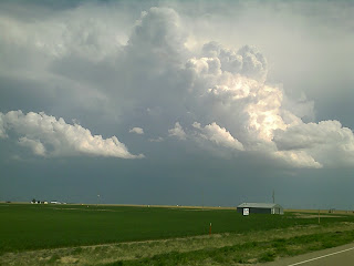
With Michael nowcasting for me I jumped on the rapidly developing cells around Leoti, KS and almost called it a day when the cell near Garden City looked like it was worth a check.

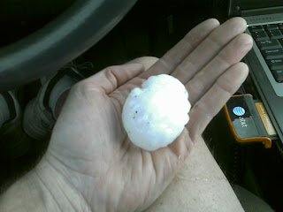
On arriving from the west side I was greeted with marbles, then golfballs and then a few near baseball hailstones and 4" drifting! I positioned myself out of the hail and on the southeast side of the meso and saw my first dusty spinup out on the forward RFD push.

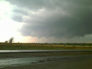
While following this gustnado I observed off to the west a nice laminar landspout with translucent tube fully connected to the ground. Out from this spout a small gustnado spun out rapidly ahead of it.

Continuing south out ahead of the meso an RFD push again turned into the huge dusty gustnado that Michael posted in the NOW thread. This weakend a bit and spun out more little gustnadoes. I decided to drive right through the dying large gustnado and got sprayed by straw and dirt!

The cell splitting and mergers or lack of mergers after that were something I can't wait to review on radar!

Michael did an analysis of the setup HERE


Wednesday, April 29, 2009

TORNADO ON THE GROUND

TOR4

TOR2

TOR3
My dad has seen four tornadoes already and is still chasing the tornadic supercell south of Garden City Kans.

MESO1

MESO2

My dad scored major today a lone supercell that produced multiple tornadoes. The whole thing was live streamed.

Michael Carlson

Bigger than golfball hail!

Garden City, KS hail drifts to 4 inches too!

Hamilton county, KS

Chasing this severe warned storm. Tornado watch issued. Live stream on TVN.

Would like to in AMA today - but eastern CO will have to do!


Had I planned a little better I would be down in AMA for the 5000 cape and 10% tornado risk. Instead I'll be trying my luck at the secondary target on the nose of the moisture plume around Burlington, CO today.

Live Streaming above and at TVN!

Equipment:
  • Dash and Cabcam - up
  • Scarecrow - up
  • WW3 - up

Monday, April 27, 2009

2009-04-26 Report

A high risk of severe weather was issued by the SPC this day.

A rarely seen 30% hatched risk for tornadoes plus most of the central plains under PDS tornado watches!

5000 Capes forecast by the RUC by 4pm CDT!


Tornado #1 21:29z west of Roll, OK on hw33 - funnel forms and touches down just to our southeast.

It tears up trees and throws sheet metal in the air.

Two cows can be seen standing to the lower right of the ground swirl. Shortly before this I saw the tornado rip a 30 foot high tree into the air and it completely disappeared before my eyes!

I punch the accelerator and floor it back east barely staying in front of it as it passes within 5o feet of the rear of our car. Dirt, rain and grass are blasting against Eric's side of the car and his face as he films!

I swing the car around as Eric films the tornado pass just behind us.


Tornado #2 21:41z south of Arnett, OK on hw283 Reed Timmer is just ahead of us coming up the hill from the Canadian river as the new stronger tornado passes just ahead of us. The RFD winds were howling from the west here!

Tornado seems to pause for a bit in the valley to our east as it climbs the hill. Unfortunately at least one house is hit. A mobile home apparently. There were no known injuries with either of these tornadoes thankfully.

The tornado is on the ground for 15 maybe 20 minutes.

A long lived stout cone that might rate as EF3 maybe low end EF 4 at it's strongest. Damage surveys will tell.

The entire meso exposes itself for a bit and we can see how powerful this tornado is!


You have to see this video!!

Sunday, April 26, 2009

Two strong tornadoes today!

Roger Mills OK we were 50 ft from the first one. 100 yds from the second! 1 rope 1 large cone!

Shattuck OK

High risk day, PDS watches! Strong cell with lowering. live stream at TVN!

Storms and Tornadoes again possible today!


Today looks great for tornadoes in the northwest OK and southcentral KS area! We will be leaving Amarillo here shortly for an initial target of Buffalo, OK and then see where the dryline intersects the lifting warmfront.

Live streaming today on TVN

Equipment
  • Dash and Cab Cam - up
  • WW3 - replacement - up
  • Scarecrow - up
  • FM Trex 600 - up

Saturday, April 25, 2009

Wheeler county texas storm

Eric and I hung out just north of Elk City, OK for most of the afternoon chatting with Fred Plowman and talking to Randy Denzer on the phone while we waited for mother nature to start her show. Randy let me know that a cell was starting to form near Wheeler, TX so we shot east on hw152 to intercept it near Mobeetie, TX (above).

The cell above already had good rainshaft/updraft separation and a few times tried to spin up some scud from almost ground level. We followed the cell to Reydon, OK where we were temped away by the storms forming along the dryline to the south of Elk City, OK.

As we drove away towards Grimes, OK we were looking back to the cell and could see it was dropping a significant lowering! We decided another look was needed so we intercepted the cell again just to the west of Cheyenne, OK. Here the updraft was doing a 'slow dance' and pulling scud off the ground in a very very slow spiral. It was at this time that Heidi Ferrar and Reed Timmer called me to ask if the storm was high based. It had gone tornado warned and was looking very intense and seemed it would produce at any moment. As the storm passed over us near Strong City, OK on hw283 it had it's best attempt yet with a lowering off to our northwest and then a spiral that went straight overhead as the TIV2 and doghouse support vehicles rolled by.

The storm once again had it's shot but fell short and we could see the base was raising again so this time we really did shoot south of I-40 getting their right at dark to see the most amazing meso below!

Crawford, OK

Trying to form a funnel!

Moderate risk for severe weather in the TX panhandle!


Yesterday: intercepted the tail-end of a cold front push line of storms in northcentral KS. Nice rock hard convection but little to no hail encountered. Some brief landspout attempts under rapidly developing towers but nothing terribly robust. Crashed and recovered WW3a after loosing visual on it during FPV storm flight. Successfully streamed entire flight under storm conditions.

Today: travel from Russell, KS down to dryline bulge, upper 60 Tds, 25oo Capes under approaching upper trough. Expect a few tornadoes and large hail today.
Live streaming for the Discovery Storm Chasers Show cross promotion above and on TVN so watch our cam later today!

Equipment:
  • WW3a - down from crash, replacement at AMA for sunday
  • Dashcam and Cabcam - up
  • Scarecrow - up
  • FM Trex 600 helicopter - up

Friday, April 24, 2009

Cell north of Concordia, KS

Look at the tower on this storm!!

Line of cells in southcentral NE

Watching this line build from just north of Concordia, KS. Live stream on TVN!

Thursday, April 23, 2009

Chase plans this weekend

Here's how this weekends' plans are shaping up for us:

Thursday - Pick up Eric at 5pm from campus, travel out to Russell, KS

Friday - early wake up, travel to eastern NE for chasing from Grand Island to Norfolk. Back to Russell overnight. Edit 18z NAM has tail-end charlie over Beatrice, NE - better yet!

Saturday - early wake up, travel to eastern TX panhandle for chasing into western OK. Travel to Amarillo overnight.

Sunday - chasing in the TX panhandle second day! Amarillo overnight.

Monday - travel back to Denver.

Equipment:
  • Dash and Cab cams - up
  • WW3a jet - up
  • FM Trex 600 - up
  • Scarecrow - up

Tuesday, April 21, 2009

Chase days coming up this weekend!

Looking more and more likely that the best chase day will be Saturday April 25th this weekend. Friday has great Tds in the 60s and huge CAPES on the NAM but the upper wave holds back to far west.

On Saturday the upper energy comes in atop an area of 2000 capes along the KS/OK border.

Sunday holds hope for southwestern OK, perhaps from Altus, OK to Childress, TX. Right now I have taken Friday and Monday off from work and will definately be out chasing. It's almost May afterall!

Monday, April 20, 2009

April 2009 Upslope Snowstorm

That's the sideview mirror of a truck under that pile of snow! The official total for this storm in Coal Creek Canyon was 52" - there was an unofficial report of 60".

Power crews work to repair downed lines. The heavy wet snow snapped numerous pine trees.

Coal Creek Canyon Convenience Store area becomes a parking lot.

Our street sign!

We had atleast 4 feet of snow at our house. I had to snowblow the driveway 5 times - each 4 hours as the snow came down!

The Carlsons', Verne, Michael and Eric

The Carlsons', Verne, Michael and Eric

Contact Me for Helicopter Shots!

Flying Monkeys

My Blog List

Blog Archive