Live Geo-referenced Storm Chaser Video. First in the Field Aerial Live Streaming and Aerial Storm Intercepts. High Resolution Level II Radar Data. Severe Weather Forecasts and Reports by Storm Chasers/Severe Weather Videographers Verne, Michael and Eric Carlson. For live stream and video licensing contact us at: vernecarlson@hotmail.com

KRDO ColoSprgs Storm Chasers!

KRDO

KAKE Wichita Storm Chase Team!

KAKE

Denver's Channel 7 Storm Chasers

KMGH 7 News

License this Live Stream Now!

Follow us LIVE on iMap Tracker! When you see a car we are live.


Friday, May 30, 2008

2008-05-29 Report

Wow what a day as it was another amazing High Risk Thursday in the plains. We caught the tornado with power flashes in Kearney, NE. The wall cloud vault was amazing on this storm. Damage is reported in Kearney and we hope that there were not any injuries as it went straight through town.

The Kearney storm was becoming disorganized so we all shot down through Hastings, NE into Kansas to the cell coming out of the west in a better environment. We caught sight of the tornado near Tipton, KS and chased it till dark north of Beliot, KS. In Jewell, KS the water tower was blown down and a church had a wall blown out. Did a lot of driving to position on the storms today so I did not get a deploy with the Wicked Witch 3. Had we been able to setup in front of one of the tornadoes with atleast a few minutes I could've been in position but it was all we could do to get up to the storms today!

Thursday, May 29, 2008

High risk of Tornadoes in Eastern Nebraska!


We are waking up in North Platte, NE this morning and the SPC has upgraded the threat today to a High Risk and 30% hatched tornadoes. Live streaming on tracker will be running. I have to run to Walmart again this morning as the Nikon Coolpix I use for aerial photos has died once again. Other than that we are out the door soon and headed east slightly to our target.

THUNDERSTORMS ARE EXPECTED TO INITIATE FIRST ALONG THE SURFACE
DRYLINE OVER WESTERN NEB/KS BY MID AFTERNOON. THESE STORMS WILL BE
RATHER HIGH-BASED...BUT WILL LIKELY BE SUPERCELLULAR DUE TO STRONG
DEEP LAYER VERTICAL SHEAR. MORE STORMS ARE EXPECTED TO DEVELOP OVER
THE WARM SECTOR IN EASTERN NEB/WESTERN IA DURING THE LATE AFTERNOON
AND EARLY EVENING IN REGION OF RELATIVELY WEAK CINH AND STRONG CAPE.
THESE STORMS WILL BE IN AN ENVIRONMENT OF LOWER LCLS...STRONGER LOW
LEVEL VERTICAL SHEAR/HELICITY...AND MORE SUBTLE FORCING. THESE
FACTORS ARE EXPECTED TO RESULT IN A SEVERAL HOUR PERIOD OF DISCRETE
SUPERCELLS CAPABLE OF VERY LARGE HAIL AND POTENTIALLY STRONG
TORNADOES.

Wednesday, May 28, 2008

Cell west of Greeley, CO

We are heading to North Platte, NE for the night to setup for tomorrow's target. Enjoying this strong developing cell to our east!

Aerial Survey of Windsor, CO

This is the neighborhood southeast of Windsor, CO that took the most damage. Here you can see all the blue tarps up over the roofs. There are many contractors in town and insurance company tents. Tomorrow morning will be one week to the day when the wedge tornado went through town at 11:30am in the morning.

This is a restaurant next to the daycare center that took major damage across the street. This is the view looking southeast into the direction the tornado came from.

Tuesday, May 27, 2008

May 21-26 2008 Video Report

I'm currently working on the video for our mega chase-cation. I have 12 tapes of footage to go through (Almost 11 hours of video!) so it's not here yet, but once I get it finalized I'll update this post with the youtube. For now though, I'll share this interesting find:

That's an HD video grab of one of Thursday's dual tornadoes. Some of the best video of the chase came from this guy. During analysis of the dust swirl I came across this little detail:

Obviously it's harder to see through a sequence of pictures, but on the video you can see a pair of trees uprooted and tossed out of view. It's things like this that make me want an HD camera of my own.

Another fun fact: The 24th was my birthday, so I had hoped to get a nice birthday tornado. Nature had a different idea however, as I got tornadoes the day before and after, but a nice blue sky bust on my birthday.

May 23 Quinter, KS Tornadoes Aerial Survey

This farmstead had roof damage and farm equipment blown around. You can see a blue tarp on the south corner of the house roof. A grain bin roof is to the north in the lower center. Castle Rock Rd is off to the right. This view is looking south-southeast.

This grain bin was blown across Castle Rock Road from the farmstead above. This view is looking southeast.
Both of these pictures were taken north of Quinter, KS on Castle Rock Road (Gove 70).

There were minimal observered tornado tracks in the wheat fields with these tornadoes. There were some arcing patterns observed in some photographs but it is uncertain if these were caused by the tornadoes themselves.

May 26 - May 26 Chase Trip!


This past six days will certainly go down as one of the most exciting chase trips we ever had. The TWISTEX crew and NGC saw collectively over 20 tornadoes in west central Kansas. We Carlson's documented 10 of them. That brings my lifetime total up to 95 tornadoes with the century mark well within reach this season. Michael and Eric are well into the double digits of 30-40 tornadoes!

Highlights of this trip were two tornadoes on the ground at the same time. Two wedge tornadoes. Two developing tornadoes intercepted at the ground swirl. Three total flights of the TWISTEX plane. One with the test dropsonde recording video and two aerial survey's of the Quinter, KS wedge tornado.

We had an incredible time with the project and look forward to getting out again soon. Maybe as early as Thurs/Fri as models are hinting at.

Monday, May 26, 2008

Chase Day 6 southwestern Kansas

Tornadoes are possible today from a Dodge City, KS to Beaver County, OK to Shamrock, TX line. We will likely shoot up to Quinter, KS this morning and do our video survey of the tornadoes that hit that area Friday and then try to hit any storms developing near the warm front near Garden City, KS - we are out the door with a busy day!

Sunday, May 25, 2008

LaCrosse KS

Just had a funnel 3/4 to the ground!

Mini LP supercell

We have a cell trying to form near Grand Island, NE. Hoping for something here.

Saturday, May 24, 2008

Day 4 Chase-apalooza. eastern NE

Looking at the RUC model data, I would put today's target at Beatrice, NE.

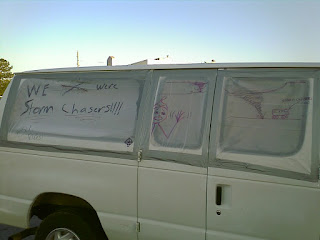
This van at our hotel with all its windows blown out describes yesterday! Our group documented numerous tornadoes in Quinter and Ness City, KS and encountered fierce tornadic winds. Our M2 mobile mesonet driven by the ISU students had a powerpole come down near the car and take off the anemometer. The NatGeo crew vehicle had it's side windows blown out by tornadic winds. The tornadoes near Quinter, KS ranged from a stout cone to a large wedge tornado. Michael, Eric and I tried to get ahead of the wedge tornado at Hill City but visibility obscured any chance of seeing it up there. We then shot down along the dryline to Ness City, KS where we encountered three separate white rope tornadoes from behind the RFD. We chased this storm up to Ogallah, KS where there were 4 semi-trailers blown over on I-70 and two large tornadoes had moved through wrapped in rain.

I have not flown the TWISTEX plane on this trip yet due to manufacturing problems with the dropsonde. The temperature sensor is reading off the board instead of the ambient air making it useless attm. Hopefully today I will get to do a test flight with the actioncam in the dropsonde or posssibly get some aerial photographs with the Nikon point and shoot.

Friday, May 23, 2008

Day 3 of chasing - West Central Kansas


As I'm writing this a severe thunderstorm is rocking our motel in Hays, KS! Today looks like another significant tornado outbreak in western Kansas with much of the same ingredients as yesterday!

...CENTRAL/SRN PLAINS...
STRONG DIABATIC SFC HEATING...COMBINED WITH ASCENT ALONG DRYLINE AND
FRONT...SHOULD CONTRIBUTE TO ADDITIONAL DEVELOPMENT MID-LATE
AFTERNOON ALONG/AHEAD OF DRYLINE AND ALONG/S OF FRONT. SUPERCELLS
FORMING IN THIS REGIME WILL OFFER THREAT OF TORNADOES ANYTIME DURING
THEIR MATURITY...BUT PARTICULARLY UPON INTERACTING WITH FRONTAL
ZONE...WHERE LOW LEVEL VORTICITY...STORM-RELATIVE FLOW AND SRH ALL
ARE MAXIMIZED. STRONGER UPPER WINDS SHOULD ALLOW FOR MORE
PRECIPITATION VENTING DOWNSHEAR...PERHAPS COUNTERBALANCING
TENDENCIES FOR SEEDING AND INTERFERENCE FROM CLOSE-PROXIMITY STORMS.
THESE FACTORS..ALONG WITH AFOREMENTIONED ENVIRONMENTAL
INGREDIENTS...SUGGEST SEVERAL LONG-LIVED/CYCLIC SUPERCELLS AGAIN ARE
POSSIBLE
...PRODUCING TORNADOES...SOME SIGNIFICANT...ALONG WITH LARGE
HAIL AND DAMAGING GUSTS.

2008-05-22 Report

This tornado was to our west.

This tornado was to our east at the same time!

An amazing chase day along I-70 in western Kansas today for many including our group.

We left the large damaging tornado north of Denver and missed it in our backyard by only an hour and a half and less than 30 miles from where we started. It was very disheartening to hear of the 3 lives lost and all the damage in Weld County which was a historically strong tornado that went northwest almost into the mountains near Laramie, WY.

Here's the tornadoes we saw today, some of which Michael's already posted some amazing pics of and Eric got the best video to come!

1) Grainfield, KS white rope tornado
2) Multi-vortex truncated cone south of Collyer, KS
3) Stout Cone south of Collyer, KS
4) Needle tornado south of Collyer, KS
5) Circulation passing of I-70 east of Collyer, KS
6) Truncated cone tornado west of Trego Center, KS

I flew one of the WW3 planes on the Stout Cone south of Collyer, KS but lost site of it in the dark conditions and it was taken far out of range and lost. I may get it back if a farmer finds it next fall during the wheat harvest and calls my cell phone number written all over the tail!

Here's the NWS page for the Quinter May 22-23rd tornado outbreak: NWS Quinter KS page

This morning was the Windsor, CO EF3 wedge tornado: NWS Windsor CO page

Thursday, May 22, 2008

TORNADO!


More photos to come...

Michael C.

Grainfield, KS

Tornado!

Oakley KS!

Tornado reported!

Day 2 of 6, Tornado Outbreak in Western Kansas!


Today we will be heading out the door here from Denver for Goodland, KS and joining up with NGC and the TWISTEX crew for a very significant day of storm chasing. WRF and RUC models are forecasting a nearly perfect setup for cyclic tornadic supercells in western Kansas. Every year you get one or two of these type days and today and tomorrow are two of them back to back! Live Streaming and Tracker will be up today.

2008-05-21 Report

This day Michael, Eric and I left Denver at 2:30pm and quickly shot out to Yuma county on hw36 and intercepted the splitting cell that formed northeast of the town of Joes, CO. It went through a few evolutions and dropped nickel sized hail. We then dropped south to the cell coming into Siebert, CO from the south and sampled the core of the storm but again only encountered nickel sized hail. Right at twilight the storm took on supercellular characteristics with striated updraft and the biggest scud-bomb we had seen all day.

Today May 22nd looks to be one of the synoptically perfect setups imaginable for tornadic supercells in western Kansas. I will be heading out the door at 8:00am, picking up the boys and heading out to meet the TWISTEX crew and NGC for the next 5 days!

Wednesday, May 21, 2008

Day 1 of 6 Chase-apalooza! Eastern WY/CO


Today starts off what will be six days of chaser nirvana begining right in our backyard. While today's moisture return will be marginal there should be enough orographic lifting and steepening lapse rates for severe storms and possible land spouts in e WY and ne CO. I will be flying all the planes today as conditions allow and will be heading out with Michael and Eric around noon today.

On a side note, I have a sneaking suspicion that today may play out like May 10, 2004. On that day everything pointed to e WY as the hotspot and most chasers (including me) shot up to Cheyenne early in the afternoon. Two storms fired over the Palmer Divide at 5pm and dropped 7 of the most photogenic tornadoes I have ever seen.

I will be keeping a keen eye on the Palmer Divide today. WRF does break out storms there at 0z (6pm MDT).

Tuesday, May 20, 2008

Video dropsonde

Tonight I completed a test dropsonde to use on the next chase that incorporates our video recorder. It is held in place by two foam bulkheads with tacks to keep it in place and has an access hole on top to allow for easy switching on/off of the video.

Announcing the Wicked Witch and Flying Monkeys Project


Near-Storm Data and Video Gathering by RC Hobby Helicopter (The Flying Monkeys Project) - by the Carlson's
Abstract: Current technology provides for sampling by Mobile Doppler Radar Vehicles in the near-storm environment above 30m. Below 30m there is a void of sampled data down to 2m where mobile mesonet and data probe deployments pick up the sampling. These MM deployments typically sample the atmosphere from 0 - 2m AGL.

The purpose of this project is to deploy a Radio Controlled Hobby Helicopter carrying atmospheric data gathering equipment to sample the near-storm environment between 0m ground level to 30m AGL.

By making transits from the deployment location 'out into the field' at a height of 30m, a sample of the near-storm environment can be recorded in a location where access to MM vehicles is limited to existing roads.


At the same time a 1080p High Definition - gyro stabilized video camera, controlled by a cameraman (separate from the pilot) will focus on capturing the view of the tornado as it approaches and passes the location. The goal is to stay aloft over the deployment site in the inflow region of the thunderstorm as a tornado passes by.


Through an agreement with TornadoVideos.Net http://www.tornadovideos.net/ - video will be streamed to thier servers in real time allowing for live viewing on the TVN website.

Video, position GPS, and thermodynamic data (temperature, pressure and humidity) will be captured throughout the inflow region and RFD passage for the single site. The ideal deployment would be to capture the inflow region and also RFD passage in the same flight while holding position.

Data Integrity: By using an electric powered helicopter, contamination of the near atmosphere by the power system will be reduced. Temperature, humidity and pressure sensors will be mounted as far from the lipo battery as possible (only slight warming source).
Data acquisition option 1 GPS, Temp, Baro, Humid?: http://www.gpsflight.com/Main/ST900e%20Overview.htm
Data acquisition option 2 OSD, GPS, Temp, Baro, Windspeed: http://www.dpcav.com/xcart/home.php?cat=263&sort=orderby&sort_direction=0&page=1
Data acquisition option 3 OSD, GPS, Temp: http://www.intelligentflight.com/webstore/Intelligent-Flight-OSD-Starter-Kit-P33.aspx
A solution for windspeed and direction is also currently being sourced.

Aerial Storm Damage Survey by RC Hobby Aircraft
Abstract: As a low cost alternative to full scale aircraft, the idea is to loft a high resolution >5Mpixel point and shoot camera to capture storm/tornado damage. Having the system readily available and in the storm chaser's vehicle, 'first light of day' undisturbed photographs can be obtained of the damage path. Close in oblique photographs from 0 - 120m can be obtained according to current FAA rules.


Wicked Witch Project Abstract:For a never-before-seen intercept of a tornado from the air we have the Wicked Witch Jets. These are disposible low cost foam aircraft that carry wireless video cameras and can be launched into the inflow of a tornado to broadcast live streaming video of the intercept!


For long duration flights (up to an hour) we will use an electric powered glider. This glider can be sent up over tornado damaged areas or at the beginning of storm initiation and can stream live video to the ground as well.

For situations where the ground target is stationary for a long period of time and winds are steady we have a KAP rig (Kite Aerial Photography) that can take digital still images and stream live video of tornado damage, hail swaths and pre-storm initiation.

FAA considerations: For 2009, Aircraft will not be instrumented so as to avoid sUAS classification. Video and photography equipment will still be employed. Aircraft will operate below 120m (400ft), flight control by line-of-site, no flight within 5 miles of any airport and utilize a spotter to warn of full-scale aircraft entering the area. No overfly of populated areas will be attempted.

Monday, May 19, 2008

Multiple Day High Plains Severe Weather!

Weds May 21
Thurs May 22 - Sat May 24
Gotta love what the GFS and SPC have been advertising for the last few days. Mid to late this week is shaping up to be a multiple day severe event for the high plains. A vigorous spring upper low is progged to cutoff over NV/s CA creating a surface low and dryline that backs west into the high plains from Weds to Sat this week. The cap will be pretty stout each day with gradual erosion from north to south. Things kick off Weds with storms in the northern plains of e WY and each day will see a southward progression of the target as the 500h temps cool.

In a year that has seen us chasing to Arkansas and within 2 hours of Mexico in central Texas this target is a welcome change. The Carlson's will be out with the TWISTEX project and witches will be flying this week!

Thursday, May 15, 2008

2008-05-14 Report


Was able to get in one WW3 flight. A little far away from the developing supercell but still was a good test flight.

Our group intercepted the San Angelo to Brady, TX tornado warned supercell yesterday. It was an HP beast blowing off tree limbs, knocking over trash cans in Brady, TX!

Wednesday, May 14, 2008

Tornadoes and large Hail Expected Today in TX


Yesterday the team intercepted a storm east of Graham, TX but it died as we arrived in the area.

Today there is better upper winds and an outflow boundary near San Angelo, TX will be our target.

WITH UPPER LOW AND ASSOCIATED MID LEVEL JET MAX MOVING INTO SRN HIGH
PLAINS THIS AFTERNOON...ALONG WITH LOW LEVEL ELY FLOW OF A STILL
MOIST AIRMASS...HAVE EXTENDED THE SLIGHT RISK WWD ACCORDINGLY
WCENTRAL TX. STRONG DEEP LAYER SHEAR OF 60-7OKT ALONG WITH LOW
LEVEL VEERING PROFILES WILL SUPPORT SUPERCELL POTENTIAL BY THIS
AFTERNOON AS AIRMASS DESTABILIZES. ADJUSTING MODEL SOUNDINGS FOR
EXPECTED SURFACE CONDITIONS RESULT IN MLCAPES TO AOA 2000 J/KG THIS
AFTERNOON...MORE THAN SUFFICIENT FOR SUPERCELLS AND TORNADO/LARGE
HAIL POTENTIAL W CENTRAL TX.

Tuesday, May 13, 2008

Big day in central OK!

Today's target is Lawton, OK. I am currently traveling from Amarillo, TX on FM287 to meet up with the TWISTEX crew after 11am CDT.


ALONG WITH STRONG INSTABILITY...WIND PROFILES SHOULD REMAIN/BECOME
FAVORABLE FOR SUPERCELLS FROM TX/OK NE INTO THE MID MS VLY AS BROAD
CURRENT OF SLIGHTLY DIFFLUENT...40-50 KT WSWLY MID-LVL FLOW PERSISTS
AHEAD OF WRN TROUGH. COUPLED WITH DEGREE OF INSTABILITY AND QUALITY
OF MOISTURE INFLOW...THE STORMS COULD YIELD VERY LARGE HAIL AND
BOWING SEGMENTS WITH HIGH WIND. A THREAT WILL ALSO EXIST FOR
TORNADOES...ESPECIALLY WITH ANY LONG-LIVED/MORE DISCRETE STORMS THAT
MIGHT FORM ALONG OR AHEAD OF THE DRY LINE.

Sunday, May 11, 2008

2008-05-10 Report

So for some reason my mobile blog posts are not coming through so I'll quickly describe Saturday May 10th's chase in se OK. The day started out in Amarillo, TX for Tony L and I heading out to OKC to meet up with Tim Samaras, Carl Young, Rich Thompson, Roger Edwards and the crew from ISU.

On the way out of AMA on I-40 I was following behind Tony in my Subaru and futzing with my power inverter under the seat while the cruise control took me down the highway at 78 mph. I looked up often and kept my eye on the road but for a second I went over the rumble strip on the center median and caught my left front tire in the grass and mud. I pulled the wheel up onto the pavement and this sent me sideways at 70 mph pulling the left front tire off the rim and sent me the opposite direction and into an uncontrolled 360 down the pavement. All I remember was the screeching tires and all my gear flying in the air around me as I came completely around and down into the grass center median. Tony had his finger on the onstar button ready to push it in case I rolled but amazingly enough the Subie stayed upright. We pulled up the road and onto the service road and changed out the tire for the spare. At Shamrock, TX all they had to do was seal my tire back on the rim and fill it with air. $6 repair and we were back on our way to OKC.

In OKC we met up with the rest of the TWISTEX crew above and headed out east to the AR/OK border on I-40. There we waited things out at a roadside truck stop and got a few CGs and pea sized hail before the initial storms rocketed away at 50+ mph. The air looked worked over in the area so the concensous was that we'd make our way south and put ourselves south of the worst terrain and be on a good N-S/E-W road option. We joked along the way about how the area is a Big Foot sighting location - some video of Big Foot would've made our chase day but he was hiding this day! We found our way through the hills and down to Broken Bow, OK where we went north looking for any kind of turnout or vista to see the now tail-end charlie tornado warned cell coming our way. We settled for a clear cut area that required a short hike off the road to where we at least had some view of the sky. The approaching storm looked very intense with striated banding, low level inflow jets and dark precip core off to our north.

The dying storms to our north pushed an out flow boundary the pushed our storm over us making us flee to the south back to Broken Bow, OK where we observed a 'cinnamon bun' overhead and rapid rain sheets blowing across the road to the west, quickly changing to the east as the rotation passed overhead.

This was a very frustrating chase for all of us due to the terrain and almost 100% saturated air and haze from Mexico caught in the warm sector. We were saddened to later hear of the loss of life to the north and east in MO and AR. Our prayers go out to those affected by this outbreak. MO and AR have been battered this year.

Friday, May 09, 2008

Amazing instability forecast for Saturday


I was not at all excited about Saturday's prospect of chasing in the hills and trees of Arkansas but the WRF CAPE forecast above turned me around! While not entirely the best chase location se OK/ne TX is a far cry better than the Ozarks. The plan is to head down with Tony L this afternoon and overnight at our place in Amarillo, then head into OKC by 10am and chase from there to points southeast. Then it's the long haul back Denver on Sunday. I will be bringing the TWISTEX plane which was successfully flown on Tuesday in west Texas and I'll also have one Wicked Witch 3 ready just in case the opportunity to fly it into a tornado presents itself.

The Carlsons', Verne, Michael and Eric

The Carlsons', Verne, Michael and Eric

Contact Me for Helicopter Shots!

Flying Monkeys

My Blog List

Blog Archive