Looking at the RUC model data, I would put today's target at Beatrice, NE.
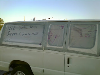
This van at our hotel with all its windows blown out describes yesterday! Our group documented numerous tornadoes in Quinter and Ness City, KS and encountered fierce tornadic winds. Our M2 mobile mesonet driven by the ISU students had a powerpole come down near the car and take off the anemometer. The NatGeo crew vehicle had it's side windows blown out by tornadic winds. The tornadoes near Quinter, KS ranged from a stout cone to a large wedge tornado. Michael, Eric and I tried to get ahead of the wedge tornado at Hill City but visibility obscured any chance of seeing it up there. We then shot down along the dryline to Ness City, KS where we encountered three separate white rope tornadoes from behind the RFD. We chased this storm up to Ogallah, KS where there were 4 semi-trailers blown over on I-70 and two large tornadoes had moved through wrapped in rain.
I have not flown the TWISTEX plane on this trip yet due to manufacturing problems with the dropsonde. The temperature sensor is reading off the board instead of the ambient air making it useless attm. Hopefully today I will get to do a test flight with the actioncam in the dropsonde or posssibly get some aerial photographs with the Nikon point and shoot.
Live Geo-referenced Storm Chaser Video. First in the Field Aerial Live Streaming and Aerial Storm Intercepts. High Resolution Level II Radar Data. Severe Weather Forecasts and Reports by Storm Chasers/Severe Weather Videographers Verne, Michael and Eric Carlson. For live stream and video licensing contact us at: vernecarlson@hotmail.com
License this Live Stream Now!
Follow us LIVE on iMap Tracker! When you see a car we are live.
Saturday, May 24, 2008
Subscribe to:
Post Comments (Atom)
The Carlsons', Verne, Michael and Eric
My Blog List
-
-
-
Frasi Di Auguri Di Fine Anno Auguri3 years ago
-
-
-
-
-
-
Odd Season8 years ago
-
Dodge City Monster9 years ago
-
Blog Has Moved10 years ago
-
-
-
Full-Up11 years ago
-
sky drama11 years ago
-
-
Hurricane Sandy11 years ago
-
A Moment in Time....11 years ago
-
-
Replacing the Free Site with Free Trials12 years ago
-
A few thoughts12 years ago
-
New York Mammatus12 years ago
-
test image13 years ago
-
-
NEW BLOG -- Update Link14 years ago
-
NEW BLOG14 years ago
-
Sams Storm Blog has moved!15 years ago
-
A World of Hurt15 years ago
-
March 28th Tornado Chase17 years ago
-
-
-
-
-
-
-
-
-
-
-
-
-
-
-
-
-
-
-
-
-
-
-
-
Links
Contributors
Blog Archive
-
▼
2008
(172)
-
▼
May
(31)
- 2008-05-29 Report
- High risk of Tornadoes in Eastern Nebraska!
- Cell west of Greeley, CO
- Aerial Survey of Windsor, CO
- May 21-26 2008 Video Report
- May 23 Quinter, KS Tornadoes Aerial Survey
- May 26 - May 26 Chase Trip!
- Chase Day 6 southwestern Kansas
- LaCrosse KS
- Mini LP supercell
- Day 4 Chase-apalooza. eastern NE
- Day 3 of chasing - West Central Kansas
- 2008-05-22 Report
- TORNADO!
- Grainfield, KS
- Oakley KS!
- Day 2 of 6, Tornado Outbreak in Western Kansas!
- 2008-05-21 Report
- Day 1 of 6 Chase-apalooza! Eastern WY/CO
- Video dropsonde
- Announcing the Wicked Witch and Flying Monkeys Pro...
- Multiple Day High Plains Severe Weather!
- 2008-05-14 Report
- Tornadoes and large Hail Expected Today in TX
- Big day in central OK!
- 2008-05-10 Report
- Amazing instability forecast for Saturday
- Waiting for storms
- Street flooding in Dumas, TX
- Couple of storm days coming up!
- TWISTEX plane complete
-
▼
May
(31)
No comments:
Post a Comment