 Tornado 1 22:13z Abbeyville, KS west of Hutchinson. Estimated 2 minutes on the ground
 Tornado 2 22:18z Partridge, KS west of Hutchinson. Estimated 3 minutes on the ground
 Tornado 3 22:29z Whiteside, KS southwest of Hutchinson. Estimated 2 minutes on the ground
At 2:00 mins in there is a large dusty bomb in the field next to me. I cannot tell if this was a tornado or not. At the time I was focused on the dirt and not the cone above it! Here is the feature at 22:40z


This day puts me over the 100 career tornado mark - I'm going to call it 101!
NWS Report

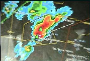
 Two radar grabs by Tony Laubach and Travis Speakman capture the cell west of Hutchinson nicely as well as my spotter network marker.
I had in my mind this morning how on Feb 10th the storms all went up well west of where they were expected and so when Tony Laubach texted me that there had been a landspout in e CO I pulled up a satellite image and kept a keep eye out towards the west. I watched the impulse come across the Dodge City area and hit the boundary near Greensburg and dramatically increase in reflectivity. I had come down south on I-35 and had the same thoughts about Mulvane and Eric as I do everytime I pass by that hallowed spot. I took the Wellington exit and headed west and then stair stepped my way up to almost Macksville and got there just as the storm really started cranking. The ICT NWS called me and asked what I was seeing. It went something like: "nothing yet, oh wait there's pea size hail, wait it's now nickles... oh I see a dust whirl, we just got a large gustnado!" From there it was one of my most exciting first chases of any season!


1 comment:
Awesome Verne! Congrats on 100+!
Post a Comment