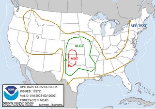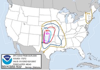
 So this afternoon Tony L. called and said "well SPC has done it to us again!" and yes they have! Tomorrow has a moderate risk along with a 45% hatched area for severe weather. I breify checked the ETA and liked everything I saw except for the 500mb winds. They seem rather weak to me for an outbreak of tornadoes. I'll have to check the other models to see if it was only the ETA.
Right now the plan is to stay up till 11pm and see what the Day 1 outlook is like. Then I will get up early-squirrley in the morning and make my decision after checking the surface obs. Michael had his car broken into again at the park and ride last night so he is recovering from his Florida trip, our trip to NE and KS weds and thurs. He would not be able to join me on Saturday so that plays into my decision to go or not. It is sure nice to have his company in the car and to have someone to share in the long haul drives back to Denver!
I'll be making my go/no go decision as late as 6am Saturday morning. I'm currently at 50% going.
Dodge City AFD:
DEWPOINTS COULD BE AROUND 60 BY6 PM SATURDAY WITH A DRYLINE SETTING UP FROM LIBERAL TO GARDEN CITY.A LEAD SHORTWAVE TROUGH WILL MOVE INTO WESTERN KANSAS ON SATURDAYAFTERNOON WITH INCREASING MID LEVEL WINDS AROUND 50 KNOTSOVERRUNNING THE DRYLINE WITH SURFACE WINDS FROM THE SOUTH TOSOUTHEAST AT 20 TO 30 MPH PROVIDING FOR STRONG LOW LEVEL SHEAR FORSUPERCELL DEVELOPMENT AND THE POTENTIAL FOR SOME TORNADOS. NEGATIVEFACTORS ARE IF THERE IS LOTS OF MID AND HIGH CLOUDS AROUND TO KEEPINSOLATION DOWN OR IF AN MCS DEVELOPS NORTH OF THE AREA ALONG A WARMFRONT. WILL INCREASE POPS FROM 20 BY LATE AFTERNOON TO AROUND 60 INTHE EAST ON SATURDAY NIGHT. THE THUNDERSTORMS WILL END FROM WEST TOEAST BY AROUND MIDNIGHT.


No comments:
Post a Comment