Live Geo-referenced Storm Chaser Video. First in the Field Aerial Live Streaming and Aerial Storm Intercepts. High Resolution Level II Radar Data. Severe Weather Forecasts and Reports by Storm Chasers/Severe Weather Videographers Verne, Michael and Eric Carlson. For live stream and video licensing contact us at: vernecarlson@hotmail.com
License this Live Stream Now!
Follow us LIVE on iMap Tracker! When you see a car we are live.
Sunday, March 12, 2006
Tornado warnings in the Kansas City Metro Area
This area is of particular interest to me since I was just there four days ago chasing!
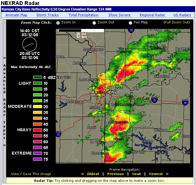
* AT 211 PM CST...TELEVISION HELICOPTER FOOTAGE SHOWED A FUNNEL CLOUD AND ROTATING WALL CLOUD WITH A VERY SEVERE THUNDERSTORM OVER KANSAS CITY KANSAS. DOPPLER RADAR SHOWED THIS TORNADIC STORM MOVING TO THE EAST AT 45 MPH.
PDS Watch issued earlier today:
URGENT - IMMEDIATE BROADCAST REQUESTED TORNADO WATCH NUMBER 73...CORRECTED NWS STORM PREDICTION CENTER NORMAN OK 1155 AM CST SUN MAR 12 2006 CORRECTED FOR WATCH REPLACEMENTS THE NWS STORM PREDICTION CENTER HAS ISSUED A TORNADO WATCH FOR PORTIONS OF CENTRAL AND WESTERN ILLINOIS EASTERN KANSAS MOST OF MISSOURI EFFECTIVE THIS SUNDAY MORNING AND EVENING FROM 1155 AM UNTIL 1000 PM CST. ...THIS IS A PARTICULARLY DANGEROUS SITUATION... DESTRUCTIVE TORNADOES...LARGE HAIL TO 4 INCHES IN DIAMETER... THUNDERSTORM WIND GUSTS TO 90 MPH...AND DANGEROUS LIGHTNING ARE POSSIBLE IN THESE AREAS. THE TORNADO WATCH AREA IS APPROXIMATELY ALONG AND 105 STATUTE MILES NORTH AND SOUTH OF A LINE FROM 30 MILES WEST OF EMPORIA KANSAS TO 35 MILES SOUTH OF DECATUR ILLINOIS. FOR A COMPLETE DEPICTION OF THE WATCH SEE THE ASSOCIATED WATCH OUTLINE UPDATE (WOUS64 KWNS WOU3). REMEMBER...A TORNADO WATCH MEANS CONDITIONS ARE FAVORABLE FOR TORNADOES AND SEVERE THUNDERSTORMS IN AND CLOSE TO THE WATCH AREA. PERSONS IN THESE AREAS SHOULD BE ON THE LOOKOUT FOR THREATENING WEATHER CONDITIONS AND LISTEN FOR LATER STATEMENTS AND POSSIBLE WARNINGS. OTHER WATCH INFORMATION...THIS TORNADO WATCH REPLACES SEVERE THUNDERSTORM WATCH NUMBER 69...SEVERE THUNDERSTORM WATCH NUMBER 70...SEVERE THUNDERSTORM WATCH NUMBER 71...SEVERE THUNDERSTORM WATCH NUMBER 72. WATCH NUMBER 69 70 71 72 WILL NOT BE IN EFFECT AFTER 1155 AM CST. DISCUSSION...RAPID DEVELOPMENT OF SUPERCELL THUNDERSTORMS WILL OCCUR EARLY THIS AFTERNOON AHEAD OF A PARTICULARLY INTENSE UPPER TROUGH AND JET STREAM MOVING INTO CENTRAL U.S. IN ADDITION TO VERY LARGE HAIL...THERE IS THE POTENTIAL FOR DAMAGING LONG TRACK TORNADOES LATER THIS AFTERNOON AND EVENING. STORMS WILL INITIATE VICINITY OF DRY LINE ERN KS AND ADDITIONALLY VICINITY WARM FRONT EXTENDING EWD ACROSS MO INTO IL.
Subscribe to:
Post Comments (Atom)
The Carlsons', Verne, Michael and Eric
My Blog List
-
-
-
Frasi Di Auguri Di Fine Anno Auguri3 years ago
-
-
-
-
-
-
Odd Season8 years ago
-
Dodge City Monster9 years ago
-
Blog Has Moved10 years ago
-
-
-
Full-Up11 years ago
-
sky drama11 years ago
-
-
Hurricane Sandy11 years ago
-
A Moment in Time....11 years ago
-
-
Replacing the Free Site with Free Trials12 years ago
-
A few thoughts12 years ago
-
New York Mammatus12 years ago
-
test image13 years ago
-
-
NEW BLOG -- Update Link14 years ago
-
NEW BLOG14 years ago
-
Sams Storm Blog has moved!15 years ago
-
A World of Hurt15 years ago
-
March 28th Tornado Chase17 years ago
-
-
-
-
-
-
-
-
-
-
-
-
-
-
-
-
-
-
-
-
-
-
-
-
Links
Contributors
Blog Archive
-
▼
2006
(417)
-
▼
March
(89)
- Missed this tornado by 10 minutes on March 30th!
- Potential Chase Day Saturday April 1st
- Interesting storm features noted.
- Chase day done!
- Latest image from Verne's mobile picture phone.
- Heading out to our next destination. Red Cloud, NE
- PDS Tornado Watch just issued for our area and south!
- Checking data at a wi-fi hotspot.
- Day 1 Outlook now posted and it looks favorable!
- Getting into position for Thursday's storm chase
- Latest image from Verne's mobile picture phone. A...
- Heading out to our next destination. Now enterin...
- Heading out to our next destination. Kansas !
- Weds March 29th Chase Day
- Having dinner at the Southern Sun with our nieces!
- Latest image from Verne's mobile picture phone.
- Latest image from Verne's mobile picture phone. T...
- Latest image from Verne's mobile picture phone.
- Thursday Mar 30th Chase Potential
- Chase potential Weds and Thurs next week
- These could be fun to chase!
- Cold core tornadoes in central OK
- First day of Spring??
- Chasing on the edge of Winter
- Latest image from Verne's mobile picture phone. Th...
- Latest image from Verne's mobile picture phone. A...
- Latest image from Verne's mobile picture phone. J...
- Entering line of showers near DearTrail, CO
- Latest image from Verne's mobile picture phone. H...
- Latest image from Verne's mobile picture phone. S...
- Katie B. texted me a message to wake up and look a...
- Up to 2 1/2 feet of snow coming to the front range...
- ...LATE SEASON STORM HEADING TOWARD NORTHEASTERN C...
- Chasing the local storms this weekend
- Saturday's TX chase too far south
- More about local setup if TX looks bleak
- DCVZ Setup coming Saturday??
- Potential Chase Day Sunday March 19th
- First Lightning of the year for Denver, CO!
- Latest image from Verne's mobile picture phone. ...
- Tornado warnings in the Kansas City Metro Area
- Black ice causes pile-up
- Latest image from Verne's mobile picture phone. ...
- Missouri under the gun again today
- From last night.
- Latest image from Verne's mobile picture phone. W...
- Latest image from Verne's mobile picture phone. ...
- Our current location is I-7O heading back to Den...
- Latest image from Verne's mobile picture phone. C...
- Latest image from Verne's mobile picture phone. T...
- Latest image from Verne's mobile picture phone. He...
- Latest image from Verne's mobile picture phone. Ha...
- Best chance for a chaseable tornado today
- Staying overnight in El Dorado
- Latest image from Verne's mobile picture phone.
- Latest image from Verne's mobile picture phone. ...
- In Wellington, KS
- Hey Tony - This one's for you!
- Latest image from Verne's mobile picture phone. ...
- SPC graphics for Tuesday March 7th
- Latest image from Verne's mobile picture phone. In...
- Road closed gotta go to Hays! Was trying to drop ...
- Latest image from Verne's mobile picture phone. ...
- Latest image from Verne's mobile picture phone. H...
- Weds Mar 8th the day?
- Tuesday March 7th Chase potential
- Snowboarding at A-Basin
- Latest image from Verne's mobile picture phone.
- Potential Tuesday Mar 7 chase
- First chase of the year!
- Our current location is 385 & 96 no action so far.
- Amarillo, TX cell was too far for me to reach, it ...
- Latest image from Verne's mobile picture phone. ...
- In Burlington, CO
- Our current location is
- Latest image from Verne's mobile picture phone. ...
- At Limon, CO checking data
- SPC Slight Risk Today!
- Keep an eye on Sunday March 12!
- Tues Mar 7th best chase day?
- Focus shifts to Mar 7 - 9
- Looking at the models and contemplating chasing
- Sup' aru Chase Vehicle
- High winds in Denver today
-
▼
March
(89)
No comments:
Post a Comment